
William George Armstrong, 1st Baron Armstrong, was an English engineer and industrialist who founded the Armstrong Whitworth manufacturing concern on Tyneside. He was also an eminent scientist, inventor and philanthropist. In collaboration with the architect Richard Norman Shaw, he built Cragside in Northumberland, the first house in the world to be lit by hydroelectricity. He is regarded as the inventor of modern artillery.

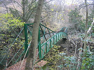
Jesmond Dene, a public park in the east end of Newcastle upon Tyne, England, occupies the narrow steep-sided valley of a small river known as the Ouseburn, flowing south to join the River Tyne: in north-east England, such valleys are commonly known as denes: the name 'Jesmond' meaning 'mouth of the Ouseburn'.
Charles Mitchell was a Scottish engineer from Aberdeen who founded major shipbuilding yards on the Tyne. He became a public benefactor who funded notable buildings that still survive today.

John Dobson was a 19th-century English architect in the neoclassical tradition. He became the most noted architect in the North of England. Churches and houses by him dot the North East - Nunnykirk Hall, Meldon Park, Mitford Hall, Lilburn Tower, St John the Baptist Church in Otterburn, Northumberland, and Beaufront Castle among them. During his career he designed more than 50 churches and 100 private houses. However, he is best known for designing Newcastle railway station and for his work with Richard Grainger developing the centre of Newcastle in a neoclassical style.

Heaton is a suburb in the east end of Newcastle upon Tyne, England, about 2 miles (3 km) from the city centre. It is bordered by the neighbouring areas of High Heaton and Cochrane Park to the north, Walker and Walkergate to the east, Byker to the south and Jesmond and Sandyford to the west. The name Heaton means high town, referring to the area "being situated on hills above the Ouseburn, a tributary of the River Tyne."

Jesmond Dene is an unincorporated community neighboring Escondido in San Diego County, California. It lies just east of Interstate 15 north of Escondido and has a ZIP Code of 92026. The community is inside area code 760.

The Newcastle town wall is a medieval defensive wall, and Scheduled Ancient Monument, in Newcastle upon Tyne, England. It was built during the 13th and 14th centuries, and helped protect the town from attack and occupation during times of conflict. It was approximately 3 kilometres (2 mi) long, at least 2 metres (6.5 ft) thick, up to 7.6 metres (25 ft) high, and had six main gates: Close Gate, West Gate, New Gate, Pilgrim Gate, Pandon Gate and Sand Gate. It also had seventeen towers, as well as several smaller turrets and postern gates. The town wall was kept in good repair whilst there was a threat of invasion from Scottish armies, and the town was successfully defended on at least two occasions; but with the decline of the border wars between England and Scotland, the wall was allowed to deteriorate.
A dene, derived from the Old English denu and frequently spelled dean in place names, used to be a common name for a valley, in which sense it is frequently found as a component of English place-names, such as Rottingdean and Ovingdean.
Castle Eden Dene is a Site of Special Scientific Interest and National Nature Reserve in the Easington district of County Durham, England. It is located mostly in Peterlee, between the A19 and A1086 roads.

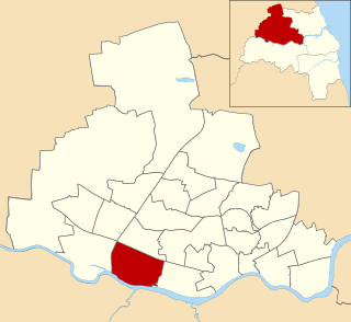
Dene is an electoral ward of Newcastle upon Tyne in North East England. The ward takes its name from the nearby gorge at Jesmond Dene. Contained within the ward are government offices of the Department for Work and Pensions and the Freeman Hospital. The population of the ward is 9,554, increasing to 9,667 at the 2011 Census, 3.7% of the total population of Newcastle upon Tyne. Car ownership in the area is 74.8% much higher than the city average of 54.7%.
Benwell and Scotswood is an electoral ward of Newcastle upon Tyne in North East England. The ward encompasses the Benwell and Scotswood housing areas, as well as the Newcastle Business Park, which is located on the banks of the River Tyne and houses offices of companies such as British Airways and the Automobile Association. The population of the ward is 13,759, which is 5.3% of the total population of Newcastle upon Tyne. Car ownership in the area is 45.1%, lower than the city average of 54.7%. The 2011 Census gave a population of 12,694.

Jesmond Park Academy is a coeducational secondary school and sixth form located in Heaton, Newcastle upon Tyne, England.
East Gosforth also known as Gosforth East is an electoral ward in Newcastle upon Tyne, Tyne and Wear, UK. It was created in 2004. The population of the ward is 8,981, increasing to 10,145 at the 2011 Census, 3.5% of the total population of Newcastle upon Tyne. Car ownership in the area is 68.8%, higher than the city average of 54.7%. It is one half of Gosforth's wards, along with the West Gosforth ward.

Jesmond is a suburb of the City of Newcastle LGA, located about 9.5 km (6 mi) west of the Newcastle CBD in the Hunter Region of New South Wales, Australia. It is both a commercial centre and dormitory suburb of Newcastle. Residents include Australian and international students attending the University of Newcastle in adjacent Callaghan. The suburb also has numerous aged housing facilities. The suburb is very multicultural due to many international university students. According to the 2006 Census there were 2,442 people in 1,144 dwellings.

Jesmond Dene House is a 19th-century mansion house at Jesmond Dene, Newcastle upon Tyne, England which is now a hotel. It is a Grade II listed building.

Jesmond is a suburb of Newcastle upon Tyne, situated to the east of the Town Moor. Jesmond is considered to be one of the most affluent suburbs of Newcastle upon Tyne, with higher average house prices than most other areas of the city.

Jesmond Vale is an area in the Ouseburn Valley, Newcastle upon Tyne, England that has a rich history with industrial archaeology, mature trees, and a variety of wildlife. It is a popular open space for recreation and for walkers.
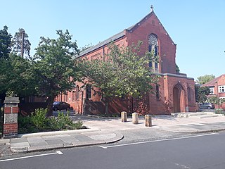
The Holy Name is a parish of the Roman Catholic Church located in the Jesmond suburb in Newcastle upon Tyne.
The Jesmond Dene Greyhound Stadium was a greyhound racing stadium in Tredegar, Blaenau Gwent, southeast Wales.


