Ouseburn

Last updated

Ouseburn
Ouseburn above the Barrage - geograph.org.uk - 1777616.jpg
Ouseburn and Barrage
Tyne and Wear UK relief location map.jpg
Red pog.svg
Location of mouth within Newcastle, shown on map of Tyne & Wear
Location
Country United Kingdom
County Tyne and Wear
Physical characteristics
Mouth  
  location
River Tyne
  coordinates
54°58′15″N1°35′18″W / 54.9708°N 1.5883°W / 54.9708; -1.5883 Coordinates: 54°58′15″N1°35′18″W / 54.9708°N 1.5883°W / 54.9708; -1.5883

The Ouseburn is a small river in Newcastle upon Tyne, England that flows through the city of Newcastle upon Tyne into the River Tyne. It gives its name to the Ouseburn Valley and the Ouseburn electoral ward for Newcastle City Council elections.

Contents

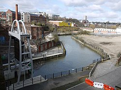
The Ouseburn has its source at Callerton in the north of the city near Newcastle Airport. It then flows through the Kingston Park area of the city, Newcastle Great Park, Gosforth Park and Whitebridge Park. The Ouseburn then continues from South Gosforth into Jesmond Dene then through Armstrong Park and Heaton Park, where it marks the boundary between Heaton and Sandyford. The river then flows through a culvert before re-emerging under Ouseburn railway viaduct, whence it flows past the City Farm, Seven Stories and the Toffee Factory and meets the River Tyne.

The river was previously tidal from the Viaduct, revealing dark mud at low tide. However, since 2009 a tidal barrage at the river mouth retains high water in the Ouseburn at low tide, with the objective of providing a more pleasant environment alongside its banks at low tide, thus promoting development. Despite the expense of its construction, the Ouseburn barrage has had operational problems and was left open for a length of time while they were corrected. [1] [2]

The lower Ouseburn Valley, whilst heavily industrialised in the past, serves as of 2013 as a hub for the arts and creative industries, and has a lively pub scene, [3] noted for live music and real ale.

In Roman times the lower Ouseburn Valley was crossed by Hadrian's Wall, but there are now no visible traces to be seen. On the eastern side of the valley, at the eastern end of a new block of flats, there is an information board [4] with an artist's impression of the Wall crossing the valley. This section of the Wall was the later extension from the Roman fort of Pons Aelius (Newcastle) to that of Segedunum (Wallsend). This newer section of the Wall was not backed by the Vallum ditch, because the River Tyne rendered it superfluous.

See also

Related Research Articles

<span class="mw-page-title-main">Newcastle upon Tyne</span> City and metropolitan borough in Tyne and Wear, England

Newcastle upon Tyne, or simply Newcastle, is a city and metropolitan borough in Tyne and Wear, England. The city is located on the River Tyne's northern bank and forms the largest part of the Tyneside built-up area. Newcastle is also the most populous city of North East England. Newcastle developed around a Roman settlement called Pons Aelius and the settlement later took the name of a castle built in 1080 by William the Conqueror's eldest son, Robert Curthose.

<span class="mw-page-title-main">River Derwent, Yorkshire</span> River in Yorkshire, England

The Derwent is a river in Yorkshire in the north of England. It flows from Fylingdales Moor in the North York Moors National Park, east then southwards as far as its confluence with the River Hertford then westwards through the Vale of Pickering, south through Kirkham Gorge and the Vale of York, joining the River Ouse at Barmby on the Marsh. The confluence is unusual in that the Derwent converges on the Ouse at a shallow angle in an upstream direction.

<span class="mw-page-title-main">The Castle, Newcastle</span> 11th-century English castle

The Castle, Newcastle, or Newcastle Castle is a medieval fortification in Newcastle upon Tyne, England, built on the site of the fortress that gave the City of Newcastle its name. The most prominent remaining structures on the site are the Castle Keep, the castle's main fortified stone tower, and the Black Gate, its fortified gatehouse.

<span class="mw-page-title-main">Haltwhistle</span> Human settlement in England

Haltwhistle is a market town and civil parish in Northumberland, England, ten miles east of Brampton. It had a population of 3,811 at the 2011 Census.

<span class="mw-page-title-main">Newcastle upon Tyne Central (UK Parliament constituency)</span> Parliamentary constituency in the United Kingdom, 1918 onwards

Newcastle upon Tyne Central is a constituency represented in the House of Commons of the UK Parliament since 2010 by Chi Onwurah of the Labour Party. As with all constituencies, the constituency elects one Member of Parliament (MP) by the first past the post system of election at least every five years.

<span class="mw-page-title-main">History of Newcastle upon Tyne</span>

The history of Newcastle upon Tyne dates back almost 2,000 years, during which it has been controlled by the Romans, the Angles and the Norsemen amongst others. Originally known by its Roman name Pons Aelius, the name "Newcastle" has been used since the Norman conquest of England. Due to its prime location on the River Tyne, the town developed greatly during the Middle Ages and it was to play a major role in the Industrial Revolution, being granted city status in 1882. Today, the city is a major retail, commercial and cultural centre.

<span class="mw-page-title-main">Elswick, Newcastle upon Tyne</span> District of Newcastle upon Tyne, England

Elswick is a district and electoral ward of the city and metropolitan borough of Newcastle upon Tyne, England, 1.9 miles west of the city centre, bordering the River Tyne. Historically in Northumberland, Elswick became part of Newcastle upon Tyne in 1835. Elswick is home to the Newcastle Utilita Arena; and Newcastle College, with approximately 45,000 students.

<span class="mw-page-title-main">Hadrian's Wall Path</span> Long-distance footpath in the north of England

Hadrian's Wall Path is a long-distance footpath in the north of England, which became the 15th National Trail in 2003. It runs for 84 miles (135 km), from Wallsend on the east coast of England to Bowness-on-Solway on the west coast. For most of its length it is close to the remains of Hadrian's Wall, the defensive wall built by the Romans on the northern border of their empire. This is now recognised as part of the "Frontiers of the Roman Empire" World Heritage Site.

<span class="mw-page-title-main">Newcastle City Council</span>

Newcastle City Council is the local government authority for the city and metropolitan borough of Newcastle upon Tyne. The council consists of 78 councillors, three for each of the 26 wards in the city. It is currently controlled by the Labour Party, led by Nick Kemp. Karen Robinson serves as the Lord Mayor and Veronica Dunn serves as Deputy Lord Mayor and Sheriff. The council is a member of the North of Tyne Combined Authority.

<span class="mw-page-title-main">Byker</span> Human settlement in England

Byker is a district in the east of the city and metropolitan borough of Newcastle upon Tyne. Home to the Byker Wall estate, made famous by TV series Byker Grove, Byker’s population was recorded at 12,206 in the 2011 census. Byker is bordered by Heaton to the north and by Shieldfield to the north east.

<span class="mw-page-title-main">Gosforth</span> Suburb of Newcastle upon Tyne, England

Gosforth is a suburb of the city and metropolitan borough of Newcastle upon Tyne, England. It constituted a separate urban district from 1895 until 1974 before officially merging with the city of Newcastle upon Tyne. In 2001, it had a population of 23,620.

<span class="mw-page-title-main">Heaton, Newcastle upon Tyne</span> Suburb of Newcastle upon Tyne, England

Heaton is a district and suburb in the city of Newcastle upon Tyne, England, 2 miles (3 km) east of the city centre. It is bordered by the neighbouring areas of Walkergate to the east, Jesmond to the north west, Byker to the south, and Sandyford to the west. The name Heaton means high town, referring to the area "being situated on hills above the Ouseburn, a tributary of the River Tyne." The area is divided into South Heaton, and High Heaton, representing the north, respectively. For city council elections, the area is split between three wards: Heaton, Manor Park and Ouseburn.

<span class="mw-page-title-main">Newcastle and North Shields Railway</span> Former English railway

The Newcastle & North Shields Railway opened in June 1839 from a temporary terminus in Carliol Square in Newcastle upon Tyne to North Shields. The railway was absorbed by the Newcastle & Berwick Railway in November 1844. The Newcastle & Berwick Railway was itself absorbed by the York, Newcastle and Berwick Railway, and this became part of the North Eastern Railway in 1854.

<span class="mw-page-title-main">Manors Metro station</span> Tyne and Wear Metro station in Newcastle upon Tyne

Manors is a Tyne and Wear Metro station, serving the Shieldfield area in Newcastle upon Tyne. It joined the network on 14 November 1982, following the opening of the fourth phase of the network, between Tynemouth and St James via Wallsend. The station is located near to Manors National Rail station, which is on the East Coast Main Line. However, the stations are not directly connected.

East Gosforth also known as Gosforth East is an electoral ward in Newcastle upon Tyne, Tyne and Wear, UK. It was created in 2004. The population of the ward is 8,981, increasing to 10,145 at the 2011 Census, 3.5% of the total population of Newcastle upon Tyne. Car ownership in the area is 68.8%, higher than the city average of 54.7%. It is one half of Gosforth's wards, along with the West Gosforth ward.

The Ouseburn Valley is the name of the valley of the Ouseburn, a small tributary of the River Tyne, running southwards through the east of Newcastle upon Tyne, England. The name refers particularly to the urbanised lower valley, spanned by three impressive bridges, which is nowadays a cultural and social oasis close to the centre of Newcastle.

<span class="mw-page-title-main">Jesmond Vale</span>

Jesmond Vale is an area in the Ouseburn Valley, Newcastle upon Tyne, England that has a rich history with industrial archaeology, mature trees, and a variety of wildlife. It is a popular open space for recreation and for walkers.

The Port of Tyne comprises the commercial docks on and around the River Tyne in Tyne and Wear in the northeast of England.

<span class="mw-page-title-main">2021 Newcastle City Council election</span>

The 2021 Newcastle City Council election took place on 6 May 2021 to elect members of Newcastle City Council in England. This was on the same day as other local elections. One-third of the seats were up for election, with two wards electing two councillors.

References

  1. "£4.7m Ouseburn Barrage turned off since 2010". Evening Chronicle. 20 July 2012. Retrieved 2 June 2014.
  2. "Former MP joins the criticism over unused Ouseburn Barrage". The Journal. 28 July 2012. Archived from the original on 2 June 2014. Retrieved 2 June 2014.
  3. "Let's move to Ouseburn: If Newcastle upon Tyne had a Shoreditch, this would be it". TheGuardian.com . 8 June 2018.
  4. "Ouseburn flats mark Hadrian's Wall line in rooftop garden - The Journal". Archived from the original on 29 November 2014.