
Washington is a town in the Sunderland district, in Tyne and Wear, England. Historically part of County Durham, it is the ancestral settlement of the local Washington family, from which the first President of the United States George Washington descended. It has a population of 67,085.

The A24 is a major road in England that runs for 53.2 miles (85.6 km) from Clapham in south-west London to Worthing on the English Channel in West Sussex via the suburbs of south-west London, as well as through the counties of Surrey and West Sussex.

Ghatkopar is a suburb in eastern Mumbai, close to which, the City's International Airport is located. The area is located on the Western corner of the Western Ghats and marks the beginning of the Ghats from Mumbai side. It is served by the railway station on the Central Line of the Mumbai Suburban Railway and the metro station on Line 1 of the Mumbai Metro. The eastern part has a large Gujarati population.
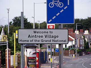
Aintree is a village and civil parish in the Metropolitan Borough of Sefton, Merseyside, England. Historically in Lancashire, it lies between Walton and Maghull on the A59 road, 6 miles northeast of Liverpool city centre. In 2011 the parish had a population of 6689.

A median strip, central reservation, roadway median, or traffic median is the reserved area that separates opposing lanes of traffic on divided roadways such as divided highways, dual carriageways, freeways, and motorways. The term also applies to divided roadways other than highways, including some major streets in urban or suburban areas. The reserved area may simply be paved, but commonly it is adapted to other functions; for example, it may accommodate decorative landscaping, trees, a median barrier, or railway, rapid transit, light rail, or streetcar lines.

Easington Lane is a village in the City of Sunderland metropolitan borough in the county of Tyne and Wear, North East England. Historically part of County Durham and located between Hetton-le-Hole, Seaham, Peterlee and Durham. It had a population of 4,044 at the 2001 Census, increasing to 7,193 at the 2011 Census.

Sulgrave is a village and civil parish in West Northamptonshire, England, about 5 miles (8 km) north of Brackley. The village is just south of a stream that rises in the parish and flows east to join the River Tove, a tributary of the Great Ouse.

Greenisland is a town in County Antrim, Northern Ireland. It lies 7 miles north-east of Belfast and 3 miles south-west of Carrickfergus. The town is on the coast of Belfast Lough and is named after a tiny islet to the west, the Green Island.
Euxton is a village and civil parish of the Borough of Chorley, in Lancashire, England. The population of the civil parish as taken at the 2011 census was 9,993, however, the population is now estimated to be around 14,000 due to the increase in housing developments in the village, including the Buckshaw development. The village is situated just to the west of Chorley, and to the south of Clayton-le-Woods.

Clifton is a suburb and historic manor in the city of Nottingham, in Nottinghamshire, England. As of the 2021 census, it had a population of 22,936.

Bescar Lane railway station is on the Manchester to Southport Line, 4.5 miles (7.2 km) east of Southport in the village of Scarisbrick. Bescar Lane is an old cottage-style station, operated by Northern Trains. Its remote location, some distance from the centre of Scarisbrick Parish, is considered to be "problematic".

Old Roan railway station is a railway station in Aintree village, Merseyside, England, about seven miles north-east of Liverpool, on the Ormskirk Branch of the Northern Line of the Merseyrail network.
Bamber Bridge is a large village in Lancashire, England, 3 miles (5 km) south-east of Preston, in the borough of South Ribble. The name derives from the Old English "bēam" and "brycg", which probably means "tree-trunk bridge". People who live in Bamber Bridge like to be known as Briggers.

The A217 is a road in London and Surrey in England. It runs north–south. It runs from Kings Road in Fulham, London, crosses the Thames at Wandsworth Bridge, then passes through Wandsworth, Earlsfield, Summerstown, Tooting, Mitcham, Rosehill and Sutton Common in Sutton, then Cheam. Then, widened as a dual carriageway, comes Belmont, a suburban district built on a slope rising southward. On the North Downs in Surrey the road then skirts past Banstead and through its late 19th century offspring villages particularly Burgh Heath and Kingswood, Surrey. It then crosses the M25 motorway at Junction 8, then, returning to single carriageways, passes through the castle town of Reigate. It then cuts through the green buffer farmland of two rural villages and terminates at the road network at Gatwick Airport's northern perimeter.
Choolaimedu is a large residential and commercial locality in Chennai, Tamil Nadu, India. It borders Kodambakkam, Vadapalani, M.M.D.A. Colony, Aminjikarai, Mahalingapuram and Nungambakkam. Previously a part of Puliyur village, Kodambakkam, Choolaimedu has now become a hub for commercial interests and connects two of the busiest routes in Chennai, namely Arcot Road and Nelson Manickam Road.

West Green is a district in north London, England, in the United Kingdom; within the London Borough of Haringey. It is located 5.7 miles (9.22 km) north of Charing Cross.

Springwell Village is a village in the City of Sunderland, bordering Gateshead, approximately 7.6 miles (12.2 km) from Newcastle upon Tyne, 9 miles (14 km) from Sunderland, and 13 miles (21 km) from Durham. In 2011, Census data for the City of Sunderland ward of Washington West recorded a total population of 11,833.
Kennessee Green is a village in the southern half of Maghull in Metropolitan Borough of Sefton, Merseyside, England. Kennessee Green has two churches: St Andrew's Church and St. Georges Church. The village of Kennessee Green is situated around Maghull railway station, St Andrew's Church and the former epileptic homes located around Damfield Lane and Deyes Lane. The village also contains two high schools, Deyes High School and Maricourt High School.
