
Gateshead is a large town in northern England. It is on the River Tyne's southern bank, opposite Newcastle to which it is joined by seven bridges. The town is famous for contemporary art and architecture such as the Millennium Bridge, The Sage, and the Baltic Centre for Contemporary Art.

North Tyneside is a metropolitan borough in the metropolitan county of Tyne and Wear, England. It forms part of the greater Tyneside conurbation. North Tyneside Council is headquartered at Cobalt Park, Wallsend.

Fenham is an area of the west-end of Newcastle upon Tyne, England. It lies to the west of the city centre, and is bounded on the north and east by a large area of open land known as the Town Moor. To the south lies Benwell, West Denton lies to the west, Blakelaw and Cowgate to the north, and Arthur's Hill and Spital Tongues to the east.

Colindale is a district in the London Borough of Barnet; its main shopping street on the A5 forming the borough boundary with neighbouring Brent. Colindale is a suburban area, and in recent years has had many new apartments built. It's also the location of the 1960s-1970s Grahame Park housing estate, built on former parts of Hendon Aerodrome. It is situated about eight miles northwest of Charing Cross, directly northwest of Hendon, to the south of Edgware and east of Queensbury.

Easton is an inner city area of the city of Bristol in the United Kingdom. Informally the area is considered to stretch east of Bristol city centre and the M32 motorway, centred on Lawrence Hill. Its southern and eastern borders are less defined, merging into St Philip's Marsh and Eastville. The area includes the Lawrence Hill and Barton Hill estates.

Walker is a residential suburb and electoral ward in the south-east of Newcastle upon Tyne, England.
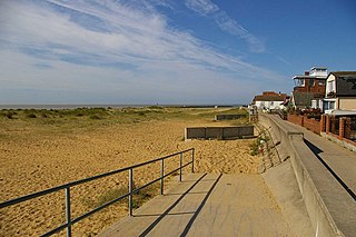
Jaywick is a coastal village in the Tendring district of Essex, England, 2 miles (3 km) west of Clacton-on-Sea. It lies on the North Sea coast of England, 60 miles (97 km) from London and 17 miles (27 km) from Colchester. It was constructed in the 1930s as a holiday resort for Londoners, but has, over time, been officially named the most deprived area in the country.
Barnes is an inner suburb in the southwest of Sunderland in northeast England, situated about a mile from the city centre. The area is split into Barnes, which lies towards the east, and High Barnes, which lies around Barnes Park and the Bede Sixth Form Centre of City of Sunderland College. Barnes is bounded by Chester Road to the north, Durham Road on the south, Springwell Road to the west and the city centre to the east. However, these boundaries are not officially set; views vary as to where the area begins and ends. The population of this ward taken at the 2011 Census was 10,987.

Greggs plc is a British bakery chain. It specialises in savoury products such as bakes, sausage rolls, sandwiches and sweet items including doughnuts and vanilla slices. It is headquartered in Newcastle upon Tyne, England. It is listed on the London Stock Exchange, and is a constituent of the FTSE 250 Index.

Byker is a district in the east of the city and metropolitan borough of Newcastle upon Tyne. Home to the Byker Wall estate, made famous by TV series Byker Grove, Byker’s population was recorded at 12,206 in the 2011 census. Byker is bordered by Heaton to the north and by Shieldfield to the north east.

Gosforth is a suburb of the city and metropolitan borough of Newcastle upon Tyne, England. It constituted a separate urban district from 1895 until 1974 before officially merging with the city of Newcastle upon Tyne. In 2001, it had a population of 23,620.

Blakelaw is an electoral ward situated in the West End of the city of Newcastle upon Tyne in North East England. The population of the ward is 11,186, which is 4.6% of the city's population. Car ownership in the area is 50.6%: this is lower than the city average of 54.7%, increasing to 11,507 at the 2011 Census. House prices in this area average at £114,000.
Thorntree is a housing estate in east Middlesbrough, North Yorkshire, England. The former Thorntree Ward's population was 6,290, at the 2011 census. Since 2015, the estate shares a ward with Brambles Farm.

Kenton is a suburb and electoral ward in the north west of Newcastle upon Tyne, England. It borders the Town Moor and Gosforth. Kenton also has close road links to Newcastle Airport. The ward population at the 2011 Census was 11,605.

Thorney Close is a suburb of Sunderland, Tyne and Wear in England.

Lawrence Hill is an electoral ward of Bristol, United Kingdom and includes the districts of Barton Hill, St Philips Marsh and Redcliffe, Temple Meads and parts of Easton and the Broadmead shopping area. Lawrence Hill takes its name from a leper hospital dedicated to St Lawrence, which was founded by King John.
Northumberland Park is a ward in the Tottenham area of London Borough of Haringey, in Greater London, England. It is largely residential, consisting of houses and flats. It is the location of Tottenham Hotspur Stadium, the home ground of Tottenham Hotspur F.C. The ward is represented by three Labour councillors.

Braunstone Park & Rowley Fields is an electoral ward and administrative division of the city of Leicester, England. It comprises the western Leicester suburbs of Braunstone Frith, Braunstone Park and Rowley Fields.

West Howe is a suburb of Bournemouth, Dorset, England, located in the north-west provinces of the borough.
Trent Vale is a village located on the western outskirts of Stoke-on-Trent in England. It is bordered on the south by Hanford, and both villages are separated by the A500. To the west is Clayton, whilst the north is Newcastle-under-Lyme. The south east is Oakhill, while Penkhull is to the north east of the village. The appropriate ward on Stoke-on-Trent MBC is called 'Springfields and Trent Vale'. The population of this ward at the 2011 census was 6,816.

