Cranebrook, New South Wales

Last updated

Cranebrook
New South Wales
Sirc bridge.jpg
Sydney International Regatta Centre
Australia New South Wales location map blank.svg
Red pog.svg
Cranebrook
Coordinates 33°43′15″S150°42′47″E / 33.72083°S 150.71306°E / -33.72083; 150.71306
Population15,759 (2016 census) [1]
Established1804
Postcode(s) 2749
Elevation40 m (131 ft)
Location65 km (40 mi) west of Sydney CBD
LGA(s) Penrith City Council
State electorate(s)
Federal division(s) Lindsay
Suburbs around Cranebrook:
Castlereagh Londonderry Londonderry
Castlereagh Cranebrook Llandilo
Jordan Springs
Mount Riverview Penrith Cambridge Gardens

Cranebrook is a suburb of Greater Western Sydney, in the state of New South Wales, Australia, and is located 50 km radially (65 km by road) WNW of the Sydney central business district, in the local government area of the City of Penrith. Cranebrook is part of the Greater Western Sydney region.

Contents

Cranebrook is surrounded by the rural suburbs of Castlereagh, Llandilo and Londonderry and has come to incorporate the Mount Pleasant housing estate, long regarded as a separate suburb.

History

Cranebrook takes its name from a pioneer farmer, James McCarthy, who was granted 100 acres (400,000 m²) of land in 1804 and named it "Crane Brook farm", after the abundance of cranes in the area. James McCarthy started a cemetery in 1804. After his four-year-old daughter died, he set aside some land to bury her in what became one of the first Catholic cemeteries in Australia. [2]

Cranebrook Post Office opened on 1 August 1886, closed in 1929, re-opened in 1934 and closed in 1957. [3]

Geography

Cranebrook's geography is hilly and many residents on the western side enjoy views across the Nepean River to the Blue Mountains. Residents on the eastern side enjoy views across the ADI Site, an area rich in Cumberland Woodland and populated with many kangaroos.

The Northern Road separates Cranebrook (to the west) from the ADI Site (to the east), an area of land around 15 square kilometres in size. Aspects relating to the sale and development of this land have been a strong local political issue. The southern boundary of Cranebrook is Andrews Road, and the northern boundary is Smeeton Road. Nearby is McCarthys Lane Cemetery, considered the oldest Catholic cemetery in Australia. The western boundary is Castlereagh Road and Church Street.

Penrith Lakes

West of Castlereagh Rd are the Penrith Lakes, a series of flooded quarries. The quarries were formed by a quarrying conglomerate in 1979. The site supplies around 75% of Sydney's sand and crushed aggregate requirements, including about 85% of the materials for ready mixed concrete. One of these lakes is the Sydney International Regatta Centre which hosted the rowing events of the Sydney 2000 Olympics. There is also the popular Penrith Whitewater Stadium which hosted whitewater slalom events for the Sydney 2000 Olympics. The Penrith Lakes Development Corporation (PLDC) oversees implementation of the Penrith Lakes Scheme.

It is a popular misconception that these lakes are filled via the Nepean River but they are actually filled via rain water and ground water. When the Nepean River floods, the lakes system can act as a weir. A Penrith Lakes Scheme Concept Plan [4] is currently under review to ensure the site delivers a wide range of environmental, social, cultural and economic values. PLDC has established a community advisory committee (CAC) which will meet regularly and provide advice on the ongoing planning and development of the lakes scheme.

The lakes were also a film location for the film Mad Max: Fury Road (2015). [5] [6]

Demographics

According to the 2016 census of Population, there were 15,759 people in Cranebrook.

Commercial area

The main commercial area of Cranebrook is on Borrowdale Way, and features a shopping centre and some parkland.

Transport

Residents of Cranebrook can access Penrith by travelling south on The Northern Road or Castlereagh Road. The trip by car is about 10 minutes. Residents can also travel to Windsor and Richmond to the north, which are about 10–15 minutes by car. The distance to the Sydney CBD is 65 km and this is best travelled by either driving down The Northern Road to the M4 Motorway or taking a train from Penrith Railway Station. Cranebrook itself has no train station (the nearest station is Penrith); however, the area is serviced by buses which can take residents into Penrith.

Schools

The three public primary schools are Braddock Public School, Henry Fulton Public School and Samuel Terry Public School. The local public high school is Cranebrook High School. At one point Xavier College was based in Cranebrook, while construction of its permanent site in Llandilo was developed.

The Catholic primary school is Corpus Christi, located in northern Cranebrook. A non-denominational Christian private school, St Paul's Grammar School, offers the IB Diploma Programme.

Churches

There are two churches in Cranebrook: Corpus Christi Catholic Church on Andromeda Drive and St Thomas's Anglican Church on Callisto Drive.

Housing

Cranebrook is a largely residential area. It contains mostly medium-density housing and some low-density semi-rural housing towards the north. Whilst some of the semi-rural areas would date to when Cranebrook was first founded, much of the medium-density development has occurred within just the last 15 years. Even today there is a regular new home construction.

As such, the population is typically local families, many of whom are home-owners or aspiring home-owners. There are some units and semi-detached houses in the Mount Pleasant area, though the majority are detached with good size house blocks, well kept gardens and abundant mature native trees.

In 2010, the swamplands in the south-western corner of Cranebrook were developed into a 53.3ha housing community named Waterside. [7] The development includes 694 high-density dwellings, lakes and parklands.

Shortly after the Waterside development completed, a new development east of Cranebrook was established. Jordan Springs is located in 229ha of former Australian Defence Industry land [8] and shares a boundary with Cranebrook via The Northern Road.

Politics

The state government electorates are Londonderry and Penrith. It is in the North Ward of the local government area of the City of Penrith. The Aboriginal district is the Deerubbin Local Aboriginal Land Council Area.

Related Research Articles

<span class="mw-page-title-main">Penrith, New South Wales</span> Town in New South Wales, Australia

Penrith is a town in New South Wales, Australia, located in Greater Western Sydney, 55 kilometres (31 mi) west of the Sydney central business district on the banks of the Nepean River, on the outskirts of the Cumberland Plain. Its elevation is 32 metres (105 ft).

<span class="mw-page-title-main">Nepean River</span> River in New South Wales, Australia

Nepean River, is a major perennial river, located in the south-west and west of Sydney, New South Wales, Australia. The Nepean River and its associated mouth, the Hawkesbury River, almost encircles the metropolitan region of Sydney.

<span class="mw-page-title-main">Agnes Banks, New South Wales</span> Suburb of City of Penrith, New South Wales, Australia

Agnes Banks is a suburb of Sydney, in the state of New South Wales, Australia. Agnes Banks is 68 kilometres north-west of the Sydney central business district, in the local government areas of the City of Penrith and City of Hawkesbury. It is part of the Greater Western Sydney region.

<span class="mw-page-title-main">Emu Plains, New South Wales</span> Suburb of Sydney, New South Wales, Australia

Emu Plains is a suburb of Sydney in the state of New South Wales, Australia. It is 58 kilometres west of the Sydney central business district, in the local government area of the City of Penrith and is part of the Greater Western Sydney region.

Kingswood is a suburb in western Sydney, in the state of New South Wales in Australia. It is 52 kilometres west of the Sydney central business district, in the local government area of the City of Penrith. There are various other locations within the state of New South Wales that are also called Kingswood, and is often confused with the nearby suburb of Kingswood Park.

<span class="mw-page-title-main">City of Penrith</span> Local government area in New South Wales, Australia

The City of Penrith is a local government area in the state of New South Wales, Australia. The seat of the city is located in Penrith, located about 50 kilometres (31 mi) west of Sydney's central business district. It occupies part of the traditional lands of the Darug people. First incorporated as a municipality on 12 May 1871, on 1 January 1949, the municipalities of Penrith, St Marys and Castlereagh and part of the Nepean Shire amalgamated to form a new Municipality of Penrith. Penrith was declared a City on 21 October 1959, and expanded westwards to include Emu Plains and Emu Heights, formerly part of the City of Blue Mountains, on 25 October 1963. As of the 2021 census the City of Penrith had an estimated population of 217,664.

<span class="mw-page-title-main">South Penrith, New South Wales</span> Suburb of Sydney, New South Wales, Australia

South Penrith is a suburb of Sydney, in the state of New South Wales, Australia. South Penrith is located 55 kilometres west of the Sydney central business district, in the local government area of the City of Penrith and is part of the Greater Western Sydney region.

Mulgoa is a village, located in the local government area of the City of Penrith, in the region of western Sydney, in the state of New South Wales, Australia. Mulgoa is located approximately 66 kilometres (41 mi) west of the Sydney central business district.

Jamisontown is a suburb of Sydney, in the state of New South Wales, Australia. It is 56 kilometres west of the Sydney central business district, in the local government area of the City of Penrith, and is part of the Greater Western Sydney region. It is on the eastern side of the Nepean River, just south of Penrith and bears the name of Thomas Jamison, a pioneer landowner and First Fleet surgeon.

Leonay is a suburb of Sydney, in the state of New South Wales, Australia 58 kilometres west of the Sydney central business district, in the local government area of the City of Penrith. It is part of the Greater Western Sydney region.

Llandilo is a suburb of Sydney, in the state of New South Wales, Australia 54 kilometres north-west of the Sydney central business district, in the local government area of the City of Penrith. It is part of the Greater Western Sydney region. Llandilo is a small semi-rural outcrop between two creeks.

Londonderry is a suburb of Greater Western Sydney, in the state of New South Wales, Australia. It is 60 kilometres north-west of the Sydney central business district, in the local government area of the City of Penrith.

<span class="mw-page-title-main">Werrington County, New South Wales</span> Suburb of Sydney, New South Wales, Australia

Werrington County is a suburb of Sydney, in the state of New South Wales, Australia. It is 50 kilometres (31 mi) west of the Sydney central business district, in the local government area of the City of Penrith and is part of the Greater Western Sydney region. The suburb is entirely residential with a high proportion of individual separate dwellings.

Maroota is a suburb to the north-west of Sydney, New South Wales, Australia. Maroota is located 49 kilometres north-west of the Sydney central business district, in the local government areas of The Hills Shire and Hornsby Shire.

<span class="mw-page-title-main">Castlereagh, New South Wales</span> Suburb of Sydney, New South Wales, Australia

Castlereagh is a suburb of Sydney, in the state of New South Wales, Australia. Castlereagh is 67 kilometres (42 mi) north-west of the Sydney central business district, in the local government area of the City of Penrith and is part of the Greater Western Sydney region.

<span class="mw-page-title-main">Glenmore Park, New South Wales</span> Suburb of Sydney, New South Wales, Australia

Glenmore Park is a suburb of Sydney, in the state of New South Wales, Australia. Glenmore Park is located 54 kilometres (34 mi) west of the Sydney central business district, in the local government area of the City of Penrith and is part of the Greater Western Sydney region.

<span class="mw-page-title-main">Penrith Whitewater Stadium</span> White water sports venue near Sydney, Australia

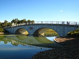
The Penrith Whitewater Stadium is located near Sydney, Australia. It is an artificial whitewater sporting facility which hosted the canoe/kayak slalom events at the 2000 Summer Olympics in Sydney. The facility is part of the Penrith Lakes Scheme, which is converting open-pit sand and gravel mines into lakes for recreation. It is close to Cranebrook and is adjacent to the Sydney International Regatta Centre. These lakes are not filled via the Nepean River, but are filled via rain water and ground water. The operation of the facility aerates the water and improves water quality in the flat water rowing and canoeing course.

Penrith Lakes is an area located in the suburb of Penrith in the Western Sydney Region, it features lakes and parklands as well as recreational facilities.

Caddens is a suburb of Sydney, in the state of New South Wales in Australia. It is a new masterplanned residential neighborhood located 48 kilometres west of the Sydney central business district, in the local government area of the City of Penrith featuring views of the scenic Blue Mountains. The suburb's postcode is 2747.

<span class="mw-page-title-main">Hadley Park</span> Heritage-listed park

Hadley Park is a heritage-listed former Aboriginal land, farm, dairy and gravel quarry and now unused building at 14-278 Old Castlereagh Road, Castlereagh, City of Penrith, New South Wales, Australia. It was built from 1803 to 1812. It was added to the New South Wales State Heritage Register on 20 April 2018.

References

  1. 1 2 Australian Bureau of Statistics (27 June 2017). "Cranebrook (State Suburb)". 2016 Census QuickStats. Retrieved 15 January 2018. OOjs UI icon edit-ltr-progressive.svg
  2. "Penrith City: Local Suburbs Profiles". Archived from the original on 19 August 2006. Retrieved 29 June 2006. Penrith Local Suburb Profiles
  3. Phoenix Options History. "Post Office List". Phoenix Auctions. Retrieved 21 February 2021.
  4. penrithlakes.com.au
  5. Moore, Ben (7 May 2015). "Mad Max: Fury Road to Roar Through Sydney Streets". Urban Cinefile. Archived from the original on 18 May 2015. Retrieved 6 May 2015.
  6. Maddox, Garry (30 November 2013). "Mad Max Fury Road: Big muddy smash caps epic shoot". The Sydney Morning Herald . Archived from the original on 8 January 2021. Retrieved 8 January 2021.
  7. "Archived copy" (PDF). Archived from the original (PDF) on 3 February 2014. Retrieved 24 January 2014.{{cite web}}: CS1 maint: archived copy as title (link)
  8. "Archived copy" (PDF). Archived from the original (PDF) on 3 February 2014. Retrieved 24 January 2014.{{cite web}}: CS1 maint: archived copy as title (link)