
The Otonabee River is a river in Peterborough County in Central Ontario, Canada. The river flows from Katchewanooka Lake, at the north end of the community of Lakefield, through the city of Peterborough to Rice Lake. It is in the Great Lakes Basin and forms part of the Trent-Severn Waterway.
Marmora and Lake is a municipality along the banks of Crowe River and Beaver Creek, about midway between Toronto and Ottawa on provincial Highway 7 in Hastings County in Central Ontario, Canada. It is home to approximately 4,000 full time and seasonal residents, many of whom enjoy outdoor recreation and relaxation on Crowe Lake.
The Moira River is a river in Hastings County in eastern Ontario, Canada. It travels from its source in the centre of the county to the Bay of Quinte at the county seat Belleville.

The Petawawa River is a river in the Saint Lawrence River drainage basin in Nipissing District and Renfrew County in eastern and northeastern Ontario, Canada. The river flows from Algonquin Provincial Park to the Ottawa River at the town of Petawawa, and is only one of two major tributaries of the Ottawa River to flow completely free. The river's name comes from the Algonquian for "where one hears a noise like this", which refers to its many rapids.

Lake Scugog is an artificially flooded lake in Scugog, Regional Municipality of Durham and the unitary city of Kawartha Lakes in central Ontario, Canada. It lies between the communities of Port Perry and Lindsay. The lake has been raised and lowered several times over its history. Though not technically part of the Kawartha lakes due to its shallow depths, it is often geographically linked to them. Its sole outflow, the Scugog River, connects to Sturgeon Lake. Lake Scugog is in the Great Lakes Basin and forms part of the Trent–Severn Waterway.

The Maitland River is a river in Huron County, Perth County and Wellington County in Southwestern Ontario, Canada. The river is in the Great Lakes Basin and empties into Lake Huron at the town of Goderich. It is 150 kilometres (93 mi) long, and is named after Sir Peregrine Maitland, Lieutenant-Governor of Upper Canada from 1818 to 1828. It was formerly known as the Menesetung River.
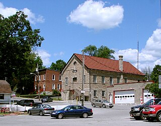
Marmora is the largest community in the Municipality of Marmora and Lake in Hastings County, Ontario, Canada. It is located on the Crowe River and along Highway 7 between Havelock to the west and Madoc to the east, about the half way point between Ottawa and Toronto.

Tangamong Lake is a lake in the Lake Ontario drainage basin in the township of Wollaston, Hastings County in eastern Ontario, Canada, at the easternmost end of the Kawartha Lakes chain. It is also part of area of responsibility of the Crowe Valley Conservation Authority.

Limerick Lake is a lake in the Trent River and Lake Ontario drainage basins in the township of Limerick, Hastings County, Ontario, Canada, about 3 kilometres (1.9 mi) northwest of the community of St. Ola, 2.5 kilometres (1.6 mi) northeast of Highway 62, and 25 kilometres (16 mi) southeast of the town of Bancroft. In 1934, the building of St. Ola Dam raised the level of Big Salmon Lake by two metres. The lake was then renamed, as part of a process in Ontario to give each large lake a unique name. The original concrete dam was assessed in 2002 and significant cracking was found. The dam was replaced in 2004 with a new concrete dam. The waterway falls under the jurisdiction of the Crowe Valley Conservation Authority which has responsibility for furthering the conservation, development, and management of natural resources, but whose main activity is flood control.
Jack Lake is a lake and reservoir in the municipalities of Havelock-Belmont-Methuen and North Kawartha, Peterborough County in Central Ontario, Canada, about 100 mi (160 km) directly northeast of Toronto and at the edge of the Canadian Shield in the northeastern portion of the Kawartha lakes region. The lake is in the Great Lakes Basin, and serves as a small headwater pond for the Trent-Severn Waterway. The Dispersed rural community of Jack Lake is on the northwest shore of the lake, reached by Peterborough County Road 52 / Jack Lake Road from the community of Apsley, about 5 kilometres (3.1 mi) to the north on Ontario Highway 28.
Paddy's Lake is a lake in the Trent River and Lake Ontario drainage basins in the township of Limerick, Hastings County, Ontario, Canada, about 1.4 kilometres (0.9 mi) southeast of the community Murphy Corners, 5.2 kilometres (3.2 mi) west of Ontario Highway 62 and 30 kilometres (19 mi) south of the town of Bancroft.

Vansickle is a dispersed rural community and unincorporated place in the municipality of Havelock-Belmont-Methuen, Peterborough County in Central Ontario, Canada. It lies just west of the Crowe River on the border with the township of Marmora and Lake in Hastings County.
Jackson Creek is a creek in Peterborough, Ontario, Canada. It is part of the Great Lakes Basin, and flows to its mouth at Little Lake as a right tributary of the Otonabee River. The Otonabee flows via the Trent River to Lake Ontario.
The Indian River is a river in Peterborough County in Central Ontario, Canada. It is in the Great Lakes Basin, and is a tributary of Rice Lake.
Koshlong Creek is a river in geographic Glamorgan Township in the municipality of Highlands East, Haliburton County in Central Ontario, Canada. The river is in the Great Lakes Basin and is a left tributary of the Burnt River.

The Black River is a river in the Regional Municipality of York and the Regional Municipality of Durham in Central Ontario, Canada. It is part of the Great Lakes Basin, and is a tributary of Lake Simcoe; the entire watershed is under the auspices of the Lake Simcoe Region Conservation Authority.
The North River is a river in the municipality of Havelock-Belmont-Methuen, Peterborough County in Central Ontario, Canada. It is part of the Great Lakes Basin, and is a right tributary of the Crowe River.
Belmont Lake is a lake in geographic Belmont Township in the municipality of Havelock-Belmont-Methuen, Peterborough County in Central Ontario, Canada. It is part of the water system that feeds the Trent Severn Waterway Great Lakes Basin.
Bowmanville Creek is a stream in the municipality of Clarington, Regional Municipality of Durham in south-central Ontario, Canada. It flows from the Oak Ridges Moraine to Lake Ontario at Bowmanville. The creek is under the auspices of the Central Lake Ontario Conservation Authority.

Millhaven Creek is a stream in the municipalities of Loyalist, Lennox and Addington County, and South Frontenac, Frontenac County, and the single-tier municipality of Kingston in eastern Ontario, Canada. It is a tributary of Lake Ontario and is under the auspices of the Cataraqui Region Conservation Authority.


