Crystal Springs, Arkansas

Last updated

Crystal Springs
USA Arkansas location map.svg
Red pog.svg
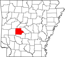
Crystal Springs
Crystal Springs's position in Arkansas.
Usa edcp location map.svg
Red pog.svg
Crystal Springs
Crystal Springs (the United States)
Coordinates: 34°31′29″N93°20′01″W / 34.52472°N 93.33361°W / 34.52472; -93.33361
Country Flag of the United States (23px).png  United States
State Flag of Arkansas.svg  Arkansas
County Garland
Elevation
[1]
203 m (666 ft)
Population
 (2020)
  Total129
Time zone UTC-6 (Central (CST))
  Summer (DST) UTC-5 (CDT)
GNIS feature ID2805634 [1]

Crystal Springs (also spelled Crystalsprings) is an unincorporated community and census-designated place (CDP) in Garland County, Arkansas, United States. [1] It was first listed as a CDP in the 2020 census with a population of 129. [2]

Contents

On April 25, 2011, a tornado associated with the 2011 Super Outbreak hit the Crystal Springs area, destroying houses in nearby Sunshine. [3]

Demographics

Historical population
CensusPop.Note
2020 129
U.S. Decennial Census [4]
2020 [5]

2020 census

Crystal Springs CDP, Arkansas – Racial and ethnic composition
Note: the US Census treats Hispanic/Latino as an ethnic category. This table excludes Latinos from the racial categories and assigns them to a separate category. Hispanics/Latinos may be of any race.
Race / Ethnicity (NH = Non-Hispanic)Pop 2020 [5] % 2020
White alone (NH)11387.60%
Black or African American alone (NH)00.00%
Native American or Alaska Native alone (NH)10.78%
Asian alone (NH)00.00%
Pacific Islander alone (NH)00.00%
Some Other Race alone (NH)00.00%
Mixed Race or Multi-Racial (NH)96.98%
Hispanic or Latino (any race)64.65%
Total129100.00%

Education

It is in the Lake Hamilton School District. [6]

Related Research Articles

<span class="mw-page-title-main">Prairie Creek, Arkansas</span> CDP in Arkansas, United States

Prairie Creek is a census-designated place (CDP) in Benton County, Arkansas, United States. Per the 2020 census, the population was 2,217. It is a lakefront community adjacent to Beaver Lake and Rogers within the Northwest Arkansas region.

<span class="mw-page-title-main">Hot Springs Village, Arkansas</span> Census-designated place in Arkansas, United States

Hot Springs Village is a census-designated place (CDP) in Garland and Saline counties in the U.S. state of Arkansas. As it is situated in two counties, it is also part of two metropolitan statistical areas. The portion in Garland County is within the Hot Springs Metropolitan Statistical Area, while the portion extending into Saline County is part of the Little Rock–North Little Rock–Conway Metropolitan Statistical Area. The population was 12,807 at the 2010 census. It is the largest gated community in the United States.

<span class="mw-page-title-main">Lake Hamilton, Arkansas</span> Census-designated place in Arkansas, United States

Lake Hamilton is a census-designated place (CDP) in Garland County, Arkansas, United States. It is part of the Hot Springs Metropolitan Statistical Area. The population was 2,135 at the 2010 census. It is named after Lake Hamilton, one of the area's man-made lakes.

<span class="mw-page-title-main">Landmark, Arkansas</span> CDP in Arkansas, United States

Landmark is a census-designated place (CDP) in Pulaski County, Arkansas, United States. Per the 2020 census, the population was 3,585. It is part of the Little Rock–North Little Rock–Conway Metropolitan Statistical Area.

Bismarck is a rural unincorporated community and census-designated place (CDP) in Hot Spring County, Arkansas. It was first listed as a CDP in the 2020 census with a population of 2,332. It is located between Hot Springs and Caddo Valley, centered around the intersection of State Hwy 7 and State Hwy 84 in Hot Spring County, Arkansas, United States.

Magnet Cove is a census-designated place (CDP) and former town in Hot Spring County, Arkansas, United States. It is located in the Ouachita Mountains southeast of Hot Springs, on Arkansas Highway 51 north of U.S. Highway 270. As of the 2020 census, the town of Magnet Cove had a population of 692.

<span class="mw-page-title-main">Roland, Arkansas</span> Census-designated place in Arkansas, United States

Roland is a census-designated place in Pulaski County, Arkansas, United States. It is part of the Central Arkansas metropolitan area. Per the 2020 census, the population was 820.

<span class="mw-page-title-main">Maysville, Arkansas</span> Census-designated place in Arkansas, United States

Maysville is an unincorporated community and census-designated place (CDP) in Benton County, Arkansas, United States. It is the westernmost settlement in the state of Arkansas. Per the 2020 census, the population was 117. It is located in the Northwest Arkansas region.

<span class="mw-page-title-main">New Blaine, Arkansas</span> Census-designated place in Arkansas, United States

New Blaine is an unincorporated community and census-designated place (CDP) in Logan County, Arkansas, United States. Per the 2020 census, the population was 173.

Midway is a census-designated place in Baxter County, Arkansas, United States. Midway is 5.5 miles (8.9 km) northwest of Mountain Home. Per the 2020 census, the population was 1,036. Midway has a post office with ZIP code 72651. Long home to a rural trading post, Midway became a boomtown during the construction of the Bull Shoals Dam, and later evolved to serve tourists and retirees attracted to the lake.

Oak Grove is an unincorporated community and census-designated place (CDP) in Moreland Township, Pope County, Arkansas, United States. It was first listed as a CDP in the 2020 census with a population of 177.

Cincinnati is an unincorporated community and census-designated place (CDP) in northwestern Washington County, Arkansas, United States. It was first listed as a CDP in the 2020 census with a population of 306.

Pearcy is an unincorporated community and census-designated place (CDP) in Garland County, Arkansas, United States. It was first listed as a CDP in the 2020 census with a population of 306.

<span class="mw-page-title-main">Holiday Island, Arkansas</span> City in Arkansas, United States

Holiday Island is a 4,500-acre planned retirement and vacation community in Carroll County, Arkansas, United States. Formerly an unincorporated community and census-designated place, it voted to incorporate in November 2020. As of the 2020 census, the population was 2,533. Holiday Island is located in the Ozark Mountains on Table Rock Lake, near Eureka Springs, Arkansas and approximately an hour's drive from Branson, Missouri, Fayetteville, Arkansas, and Bentonville, Arkansas. Community growth has been fueled by the expansion of corporate giants headquartered in Northwest Arkansas, namely Walmart, Tyson Foods, and J.B. Hunt; the entertainment attractions in Eureka Springs, AR and Branson, MO; the visitor traffic from the Crystal Bridges Museum of American Art, the Pea Ridge National Military Park, and the Roaring River State Park; and the influence of University of Arkansas, the state's largest university.

<span class="mw-page-title-main">Lost Bridge Village, Arkansas</span> Census-designated place in Arkansas, United States

Lost Bridge Village is a residential subdivision near the town of Garfield in Benton County, Arkansas, United States. Per the 2020 census, the population was 397. It is located in the Northwest Arkansas region.

<span class="mw-page-title-main">Staves, Arkansas</span> Census-designated place in Arkansas, United States

Staves is a census-designated place in Cleveland County, Arkansas, United States. Per the 2020 census, the population was 133.

<span class="mw-page-title-main">Tumbling Shoals, Arkansas</span> Census-designated place in Arkansas, United States

Tumbling Shoals is a census-designated place in Cleburne County, Arkansas, United States. Per the 2020 census, the population was 902.

Witts Springs is an unincorporated community and census-designated place (CDP) in Searcy County, Arkansas, United States. It was first listed as a CDP in the 2020 census with a population of 33. Witts Springs is located on Arkansas Highway 16, 16.5 miles (26.6 km) southwest of Marshall. Witts Springs has a post office with ZIP code 72686. John Campbell who served in Mexico and the Confederate Army and who was a county surveyor and judge as well as a state senator for two terms had his post office at Witts Springs.

Saratoga is an unincorporated community and census-designated place (CDP) in Hempstead and Howard counties, Arkansas, United States. Per the 2020 census, the population was 124.

Wilburn is an unincorporated community and census-designated place (CDP) in Cleburne County, Arkansas, United States. Wilburn is located on Arkansas Highway 110, 8 miles (13 km) east of Heber Springs. Wilburn has a post office with ZIP code 72179.

References

  1. 1 2 3 U.S. Geological Survey Geographic Names Information System: Crystal Springs, Arkansas
  2. "Crystal Springs CDP, Arkansas". United States Census Bureau . Retrieved April 7, 2022.
  3. NOAA report
  4. "Decennial Census of Population and Housing by Decades". US Census Bureau.
  5. 1 2 "P2 Hispanic or Latino, and Not Hispanic or Latino by Race – 2020: DEC Redistricting Data (PL 94-171) – Crystal Springs CDP, Arkansas". United States Census Bureau .
  6. "SCHOOL DISTRICT REFERENCE MAP (2010 CENSUS): Garland County, AR" (PDF). U.S. Census Bureau . Retrieved March 3, 2021.