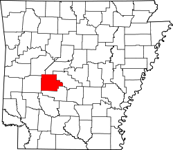
Piney, Arkansas | |
---|---|
Coordinates: 34°30′08″N93°08′28″W / 34.50222°N 93.14111°W | |
Country | United States |
State | Arkansas |
County | Garland |
Area | |
• Total | 7.11 sq mi (18.42 km2) |
• Land | 6.51 sq mi (16.85 km2) |
• Water | 0.60 sq mi (1.56 km2) |
Elevation | 509 ft (155 m) |
Population (2020) | |
• Total | 5,238 |
• Density | 804.98/sq mi (310.80/km2) |
Time zone | UTC-6 (Central (CST)) |
• Summer (DST) | UTC-5 (CDT) |
ZIP code | 71901 |
Area code | 501 |
FIPS code | 05-55610 |
GNIS feature ID | 2403421 [2] |
Piney is a census-designated place (CDP) in Garland County, Arkansas, United States. The population was 4,699 at the 2010 census. [3]
According to the United States Census Bureau, the CDP has a total area of 7.1 square miles (18.5 km2), of which 6.5 square miles (16.9 km2) is land and 0.6 square mile (1.5 km2) (8.27%) is water.
Census | Pop. | Note | %± |
---|---|---|---|
1990 | 2,500 | — | |
2000 | 3,988 | 59.5% | |
2010 | 4,699 | 17.8% | |
2020 | 5,238 | 11.5% | |
U.S. Decennial Census [4] |
Race | Number | Percentage |
---|---|---|
White (non-Hispanic) | 3,941 | 75.24% |
Black or African American (non-Hispanic) | 314 | 5.99% |
Native American | 39 | 0.74% |
Asian | 53 | 1.01% |
Pacific Islander | 2 | 0.04% |
Other/Mixed | 333 | 6.36% |
Hispanic or Latino | 556 | 10.61% |
As of the 2020 United States census, there were 5,238 people, 1,977 households, and 1,129 families residing in the CDP.
As of the census [6] of 2000, there were 3,988 people, 1,617 households, and 1,193 families residing in the CDP. The population density was 609.7 inhabitants per square mile (235.4/km2). There were 1,868 housing units at an average density of 285.6 per square mile (110.3/km2). The racial makeup of the CDP was 93.03% White, 2.26% Black or African American, 1.15% Native American, 0.18% Asian, 0.10% Pacific Islander, 1.35% from other races, and 1.93% from two or more races. 3.31% of the population were Hispanic or Latino of any race.
There were 1,617 households, out of which 33.3% had children under the age of 18 living with them, 56.3% were married couples living together, 12.8% had a female householder with no husband present, and 26.2% were non-families. 21.2% of all households were made up of individuals, and 7.3% had someone living alone who was 65 years of age or older. The average household size was 2.46 and the average family size was 2.83.
In the CDP, the population was spread out, with 25.3% under the age of 18, 7.5% from 18 to 24, 30.6% from 25 to 44, 23.5% from 45 to 64, and 13.2% who were 65 years of age or older. The median age was 36 years. For every 100 females, there were 100.8 males. For every 100 females age 18 and over, there were 96.8 males.
The median income for a household in the CDP was $31,827, and the median income for a family was $34,780. Males had a median income of $26,078 versus $20,709 for females. The per capita income for the CDP was $15,055. About 12.4% of families and 16.0% of the population were below the poverty line, including 21.8% of those under age 18 and 9.5% of those age 65 or over.
Most of the CDP is in the Lake Hamilton School District while another portion is in the Mountain Pine School District. [7]
Moores Mill is an unincorporated community and census-designated place (CDP) in Madison County, Alabama, United States, and is included in the Huntsville-Decatur Combined Statistical Area. The population was 6,729 at the 2020 census, up from 5,682 at the 2010 census.
Lake Hamilton is a census-designated place (CDP) in Garland County, Arkansas, United States. It is part of the Hot Springs Metropolitan Statistical Area. The population was 2,135 at the 2010 census. It is named after Lake Hamilton, one of the area's man-made lakes.
Rockwell is a census-designated place (CDP) in Garland County, Arkansas, United States. The population was 3,780 at the 2010 census.
Caruthers is a census-designated place (CDP) in Fresno County, California, United States. The population was 2,497 at the 2010 census, up from 2,103 at the 2000 census. Caruthers is located 15 miles (24 km) south of downtown Fresno, at an elevation of 246 feet.
Brookridge is a census-designated place (CDP) in Hernando County, Florida, United States. The population was 4,420 at the 2010 census, up from 3,279 at the 2000 census.
Makakilo or Makakilo City is a census-designated place and residential area located in the ʻEwa District on the island of Oʻahu in the City & County of Honolulu, United States. In Hawaiian, maka kilo means "observing eyes". As of the 2020 census, the CDP had a population of 19,877.
LaVale is a census-designated place (CDP) in Allegany County, Maryland, United States. It is part of the Cumberland, MD-WV Metropolitan Statistical Area. The population was 4,201 as of the 2020 census.
St. Charles is a planned community in Charles County, Maryland, United States. It is 22 miles (35 km) south-southeast of Washington, D.C., 24 miles (39 km) from northern Virginia and immediately south of Waldorf, which is the mailing address.. At the 2000 census, it was delineated as a census-designated place (CDP), with a population of 33,379. It was included in the Waldorf CDP for the 2010 census.
Cedar Glen Lakes is an unincorporated community and census-designated place (CDP) located within Manchester Township, in Ocean County, in the U.S. state of New Jersey. As of the 2010 United States Census, the CDP's population was 1,421.
Piney Green is a census-designated place (CDP) in Onslow County, North Carolina, United States. The population was 11,658 at the 2000 census. It is part of the Jacksonville, North Carolina Metropolitan Statistical Area.
Holmesville is a village in Holmes County, Ohio, United States, along Killbuck Creek. The population was 371 at the 2020 census.
Shiloh is a census-designated place (CDP) in Harrison Township in Montgomery County, Ohio, United States. It was delineated as a census-designated place at the 2000 census, at which time its population was 11,272. It was not delineated as a CDP at the 2010 census. It is located directly north of the city of Dayton and is part of the Dayton Metropolitan Statistical Area.
Crabtree is a census-designated place (CDP) and former coal town in Salem Township, Westmoreland County, Pennsylvania, United States. The population was 277 at the 2010 census. It has its own post office, with postal code 15624.
Seven Oaks is a census-designated place (CDP) in Lexington County, South Carolina, United States, 8 miles (13 km) northwest of downtown Columbia, the state capital. The population of the CDP was 15,144 at the 2010 census. It is part of the Columbia Metropolitan Statistical Area.
Abram-Perezville is a former census-designated place (CDP) in Hidalgo County, Texas. The population was 5,376 at the 2010 United States Census. It is part of the McAllen–Edinburg–Mission Metropolitan Statistical Area. For the 2010 census, the CDP was split into Abram and Perezville.
Piney View is a census-designated place (CDP) in Raleigh County, West Virginia, United States. The population was 989 at the 2010 census.
Garland is a census-designated place (CDP)in Park County, Wyoming, United States. The population was 115 at the 2010 census.
Calpet is an unincorporated community in Sublette County, Wyoming, United States. The population was 7 at the 2000 census, when it was a census-designated place (CDP).
Loveland Park is a census-designated place (CDP) located in Symmes Township, Hamilton County and Deerfield Township, Warren County, in the southwestern part of the U.S. state of Ohio. The CDP is named after the city of Loveland. The population was 1,737 at the 2020 census.
Tonawanda is a census-designated place (CDP) in Erie County, New York, United States. The CDP comprises the town of Tonawanda minus its subsidiary village of Kenmore. As of the 2010 census, the CDP population was 58,144.