Rockwell, Arkansas

Last updated

Rockwell, Arkansas
CDP
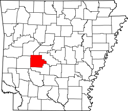
Garland County Arkansas Incorporated and Unincorporated areas Rockwell Highlighted.svg
Location in Garland County and the state of Arkansas
Coordinates: 34°27′32″N93°07′45″W / 34.45889°N 93.12917°W / 34.45889; -93.12917
Country United States
State Arkansas
County Garland
Area
[1]
  Total4.33 sq mi (11.21 km2)
  Land3.27 sq mi (8.48 km2)
  Water1.06 sq mi (2.74 km2)
Elevation
[2]
446 ft (136 m)
Population
 (2020)
  Total4,548
  Density1,389.98/sq mi (536.60/km2)
Time zone UTC-6 (Central (CST))
  Summer (DST) UTC-5 (CDT)
ZIP code
71913 [3]
Area code 501
FIPS code 05-60110
GNIS feature ID2403489 [2]

Rockwell is a census-designated place (CDP) in Garland County, Arkansas, United States. The population was 3,780 at the 2010 census. [4]

Contents

Geography

According to the United States Census Bureau, the CDP has a total area of 4.2 square miles (11 km2), of which 3.1 square miles (8.0 km2) is land and 1.1 square miles (2.8 km2) (25.17%) is water.

Demographics

Historical population
CensusPop.Note
2020 4,548
U.S. Decennial Census [5]

2020 census

Rockwell racial composition [6]
RaceNumberPercentage
White (non-Hispanic)3,78983.31%
Black or African American (non-Hispanic)2184.79%
Native American 200.44%
Asian 621.36%
Pacific Islander 20.04%
Other/Mixed 2455.39%
Hispanic or Latino 2124.66%

As of the 2020 United States census, there were 4,548 people, 1,910 households, and 1,287 families residing in the CDP.

2000 census

As of the census [7] of 2000, there were 3,024 people, 1,274 households, and 931 families residing in the CDP. The population density was 956.4 inhabitants per square mile (369.3/km2). There were 1,549 housing units at an average density of 489.9 per square mile (189.2/km2). The racial makeup of the CDP was 97.12% White, 0.83% Black or African American, 0.40% Native American, 0.26% Asian, 0.13% from other races, and 1.26% from two or more races. 0.86% of the population were Hispanic or Latino of any race.

There were 1,274 households, out of which 27.1% had children under the age of 18 living with them, 61.7% were married couples living together, 8.6% had a female householder with no husband present, and 26.9% were non-families. 23.2% of all households were made up of individuals, and 10.6% had someone living alone who was 65 years of age or older. The average household size was 2.37 and the average family size was 2.77.

In the CDP, the population was spread out, with 21.2% under the age of 18, 5.0% from 18 to 24, 26.4% from 25 to 44, 28.9% from 45 to 64, and 18.4% who were 65 years of age or older. The median age was 43 years. For every 100 females, there were 94.8 males. For every 100 females age 18 and over, there were 90.9 males.

The median income for a household in the CDP was $46,366, and the median income for a family was $53,241. Males had a median income of $39,175 versus $30,035 for females. The per capita income for the CDP was $24,647. About 2.7% of families and 4.5% of the population were below the poverty line, including 5.6% of those under age 18 and 1.4% of those age 65 or over.

Education

It is in the Lake Hamilton School District. [8]

Related Research Articles

<span class="mw-page-title-main">Lake Hamilton, Arkansas</span> Census-designated place in Arkansas, United States

Lake Hamilton is a census-designated place (CDP) in Garland County, Arkansas, United States. It is part of the Hot Springs Metropolitan Statistical Area. The population was 2,135 at the 2010 census. It is named after Lake Hamilton, one of the area's man-made lakes.

<span class="mw-page-title-main">Piney, Garland County, Arkansas</span> CDP in Arkansas, United States

Piney is a census-designated place (CDP) in Garland County, Arkansas, United States. The population was 4,699 at the 2010 census.

<span class="mw-page-title-main">Riverdale, California</span> Census-designated place in California, United States

Riverdale is a census-designated place (CDP) in Fresno County, California, United States. The population was 3,153 at the 2010 census, up from 2,416 at the 2000 census. Riverdale is located 23 miles (37 km) south of Fresno, at an elevation of 223 ft (68 m).

<span class="mw-page-title-main">El Cerrito, Riverside County, California</span> Census-designated place in Riverside County, California, United States

El Cerrito is a census-designated place (CDP) in Riverside County, California, United States. It is an unincorporated area mostly surrounded by the city of Corona. The population was 5,100 at the 2010 census, up from 4,590 at the 2000 census.

<span class="mw-page-title-main">June Park, Florida</span> Census-designated place in Florida

June Park is a census-designated place (CDP) in Brevard County, Florida. The population was 4,283 at the 2020 United States census, up from 4,094 at the 2010 United States Census. It is part of the Palm Bay–Melbourne–Titusville, Florida Metropolitan Statistical Area.

<span class="mw-page-title-main">Jasmine Estates, Florida</span> CDP in Florida, United States

Jasmine Estates is a census-designated place (CDP) in Pasco County, Florida, United States. The population was 18,989 according to the 2010 census.

<span class="mw-page-title-main">ʻEwa Villages, Hawaii</span> Census-designated place in Hawaii, United States

ʻEwa Villages is a census-designated place (CDP) located in the ʻEwa District and the City & County of Honolulu on the leeward side of Oʻahu in Hawaiʻi approximately 20 miles (32 km) from downtown Honolulu. As of the 2020 census, the CDP had a population of 7,825.

Venetian Village is a census-designated place (CDP) in Lake County, Illinois, United States. Per the 2020 census, the population was 2,761.

Exeter is a town in Penobscot County, Maine, United States. The population was 963 at the 2020 census.

<span class="mw-page-title-main">Naval Academy, Maryland</span> Census-designated place in Maryland, United States

Naval Academy is a census-designated place (CDP) in Anne Arundel County, Maryland, United States, which covers the campus of the United States Naval Academy. The population was 4,802 at the 2010 census.

<span class="mw-page-title-main">Country Club Hills, Missouri</span> City in Missouri, United States

Country Club Hills is a city in St. Louis County, Missouri, United States. The population was 1,274 at the 2010 census.

<span class="mw-page-title-main">Glide, Oregon</span> Census-designated place in Oregon, United States

Glide is a census-designated place (CDP) in Douglas County, Oregon, United States. The population was 1,795 at the 2010 census.

<span class="mw-page-title-main">Sadsbury Township, Crawford County, Pennsylvania</span> Township in Pennsylvania, United States

Sadsbury Township is a township in Crawford County, Pennsylvania, United States. The population was 2,752 at the 2020 census, down from 2,933 at the 2010 census.

<span class="mw-page-title-main">Dentsville, South Carolina</span> Census-designated place in South Carolina, United States

Dentsville is a census-designated place (CDP) in Richland County, South Carolina, United States. The population was 14,062 at the 2010 census. It is part of the Columbia, South Carolina, Metropolitan Statistical Area.

<span class="mw-page-title-main">Homestead Meadows South, Texas</span> Census-designated place in Texas, United States

Homestead Meadows South is a census-designated place (CDP) in El Paso County, Texas, United States. The population was 7,247 at the 2010 census. It is part of the El Paso Metropolitan Statistical Area. The ZIP Code encompassing the CDP area is 79938.

Garland is a census-designated place (CDP)in Park County, Wyoming, United States. The population was 115 at the 2010 census.

<span class="mw-page-title-main">Loveland Park, Ohio</span> Census-designated place in Ohio, United States

Loveland Park is a census-designated place (CDP) located in Symmes Township, Hamilton County and Deerfield Township, Warren County, in the southwestern part of the U.S. state of Ohio. The CDP is named after the city of Loveland. The population was 1,737 at the 2020 census.

<span class="mw-page-title-main">West Seneca (CDP), New York</span> Census-designated place in New York, United States

West Seneca is a hamlet and census-designated place (CDP) in Erie County, New York, United States. The population was 44,711 at the 2010 census. It is part of the Buffalo–Niagara Falls Metropolitan Statistical Area. The CDP corresponds exactly to the area of the town of West Seneca.

Dexter is a census-designated place (CDP) comprising the main settlement within the town of Dexter in Penobscot County, Maine, United States. The population of the CDP was 2,158 at the 2010 census.

Machias is a census-designated place (CDP) corresponding to the central village area within the town of Machias in Washington County, Maine, United States. The population of the CDP was 1,274 at the 2010 census.

References

  1. "2020 U.S. Gazetteer Files". United States Census Bureau. Retrieved October 29, 2021.
  2. 1 2 U.S. Geological Survey Geographic Names Information System: Rockwell, Arkansas
  3. "Rockwell AR ZIP Code". zipdatamaps.com. 2023. Retrieved January 26, 2023.
  4. "U.S. Census website". U.S. Census Bureau . Retrieved May 6, 2011.
  5. "Census of Population and Housing". Census.gov. Retrieved June 4, 2016.
  6. "Explore Census Data". data.census.gov. Retrieved December 31, 2021.
  7. "U.S. Census website". United States Census Bureau . Retrieved January 31, 2008.
  8. "SCHOOL DISTRICT REFERENCE MAP (2010 CENSUS): Garland County, AR" (PDF). U.S. Census Bureau . Retrieved March 3, 2021.