
Vršac is a city located in the South Banat District of the autonomous province of Vojvodina, Serbia. As of 2011, the city urban area has a population of 35,701, while the city administrative area has 52,026 inhabitants. It is located in the geographical region of Banat.

Zala is an administrative county in south-western Hungary. It is named after the Zala River. It shares borders with Croatia and Slovenia and the Hungarian counties Vas, Veszprém and Somogy. The capital of Zala county is Zalaegerszeg. Its area is 3,784 square kilometres (1,461 sq mi). Lake Balaton lies partly in the county.

Lučenec is a town in the Banská Bystrica Region of south-central Slovakia. Historically, it was part, and in the 18th century the capital, of Nógrád County of the Kingdom of Hungary. In 1920, as a result of the Treaty of Trianon, it became a part of Czechoslovakia. The town has a large synagogue, built in 1924, which served a large Jewish population before World War II. The synagogue underwent renovations in 2016.

Snina is a town in Slovakia located at the confluence of the Cirocha river and the small river Pčolinka in the valley between the Beskydy foothills and the Vihorlat Mountains. It is the closest town with rail and bus connections to Poloniny National Park.

Keszthely is a Hungarian city of 20,895 inhabitants located on the western shore of Lake Balaton. It is the largest city by the lake and one of the more important cultural, educational and economic hubs in the region. Due to its favorable location and accessibility by both road and rail, Keszthely and the surrounding area is a preferred holiday destination.

Kırklareli is a city in the European part of Turkey.

Kolárovo is a town in the south of Slovakia near the town of Komárno. It is an agricultural center with 11,000 inhabitants.

Nevşehir, formerly Neapolis and Muşkara, is a city and the capital district of Nevşehir Province in the Central Anatolia Region of Turkey. According to the 2010 census, the population of the district is 117,890 of which 85,634 live in the city of Nevşehir. The district covers an area of 535 km2 (207 sq mi), and the town lies at an elevation of 1,224 m (4,016 ft).

Finike, the ancient Phoenix or Phoinix, also formerly Phineka, is a district on the Mediterranean coast of Antalya Province in Turkey, to the west of the city of Antalya, along the Turkish Riviera. It is located on the southern shore of the Teke peninsula, and the coast here is a popular tourist destination. However, Finike is best known for its oranges, the symbol of the town.
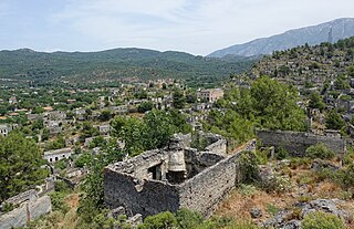
Kayaköy, anciently known in Greek as Karmilassos, shortened to Lebessos and pronounced in Modern Greek as Livissi, is presently a village 8 km south of Fethiye in southwestern Turkey in the old Lycia province. From Ancient Greek the town name shifted to Koine Greek by the Roman period, evolved into Byzantine Greek in the Middle Ages, and finally became the Modern Greek name still used by its townspeople before their final evacuation in 1923.

Kommeno is a village and a former community in the Arta regional unit, Epirus, Greece. Since the 2011 local government reform it is part of the municipality Nikolaos Skoufas, of which it is a municipal unit. The municipal unit has an area of 14.354 km2. Population 769 (2011).

Doroslovo is a village in Serbia. It is located in the municipality of Sombor, West Bačka District, Vojvodina province. The population of the village numbering 1,830 people and most of its inhabitants are ethnic Hungarians. Villagers are mostly preoccupied with farming. It is widely known as a Christian pilgrimage site.

San Biagio Saracinisco is a comune (municipality) in the Province of Frosinone in the Italian region of Lazio, located about 120 kilometres (75 mi) east of Rome and about 50 kilometres (31 mi) east of Frosinone.

Nagykovácsi is a small town in the Pilisvörösvári kistérség district of Hungary situated some 15 km (9 mi) north-west of the centre of Budapest, in a valley, at an altitude of 340 metres. It is located next to the second district of Budapest. According to the 2011 census, its population was given as 7095, though this figure does not include the many people who own a property there as a second residence. The town is known for its scenic setting in surrounding hills and forests, and much of the nearby forest have been designated conservation areas—Budai Tájvédelmi Körzet —in order to protect several rare species of flora growing there. Its location has contributed to the town's development in recent years. The American International School of Budapest chose Nagykovácsi as the site for its new campus in 2000.
Körösnagyharsány (Körös-Nagy-Harsány) is a village in Békés County, in the Southern Great Plain region of south-east Hungary.

Hévíz is a spa town in Zala County, Hungary, about 8 kilometres from Keszthely.

Tarcal is a village on the eastern edge of Borsod-Abaúj-Zemplén county, northern Hungary, in the famous Tokaj-Hegyalja wine district, 55 km (34 mi) from Miskolc.
Szalmatercs is a village in Nógrád county, Hungary.
The village of Újcsanálos is located in the county of Borsod-Abaúj-Zemplén, in the Miskolc district, in the valley of the Hernád river, the same distance from Miskolc and Szerencs, which is part of the historic Zemplén county, including the Harangod region.

Keszthely is a district in eastern part of Zala County. Keszthely is also the name of the town where the district seat is found. The district is located in the Western Transdanubia Statistical Region.


