Cuba is an island nation in the Caribbean Sea. Cuba has an official area of 109,884 km2 (42,426 sq mi). Its area is 110,860 km2 (42,800 sq mi) including coastal and territorial waters. The main island (Cuba) has 5,746 km (3,570 mi) of coastline and 28.5 km (17.7 mi) of land borders—all figures including the United States territory at Guantánamo Bay, where the U.S. Navy's Guantanamo Bay Naval Base is located.

Lake Isabella is a census-designated place (CDP) in the southern Sierra Nevada, in Kern County, California, United States. It is named after the Lake Isabella reservoir and located at its southwestern edge, 6 miles (9.7 km) south of Wofford Heights in the Kern River Valley.
Weedpatch is an unincorporated community and census-designated place (CDP) in Kern County, California, United States. Weedpatch is 10 miles (16 km) south-southeast of Bakersfield. It is considered to be one of the poorest areas in Kern County. As of the 2010 census it had a population of 2,658.

Key West is an island and city in the Straits of Florida on the North American continent. The city lies at the southernmost end of U.S. Route 1, the longest north-south road in the United States. Key West is the southernmost city in the contiguous United States and the westernmost island connected by highway in the Florida Keys. The island is about 4 miles (6.4 km) long and 1 mile (1.6 km) wide, with a total land mass of 4.2 square miles (11 km2). Duval Street, its main street, is 1.1 miles (1.8 km) in length in its 14-block-long crossing from the Gulf of Mexico to the Straits of Florida and the Atlantic Ocean. Key West is about 95 miles (153 km) north of Cuba at their closest points.

Cuba is a city in Fulton County, Illinois, United States. The population was 1,294 at the 2010 census, down from 1,418 at the 2000 census.

Cuba Township is a township in Becker County, Minnesota, United States. The population was 208 as of the 2000 census.

Cuba is a town on the western border of Allegany County, New York, United States. The village of Cuba lies within its borders. The federally recognized tribe of Seneca Native Americans has a reservation on the western town line. As of the 2010 Census, the total population was 3,243.
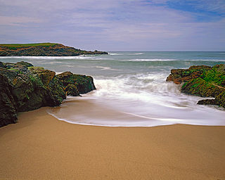
Bean Hollow State Beach is a beach in the state park system of California, USA. It is located in San Mateo County near Pescadero. The beach offers fishing, picnicking and beachcombing. Visitors can explore tide pools with anemones, crab, sea urchins and other marine inhabitants. The beach also has a self-guided nature trail. Swimming is dangerous because of cold water, rip currents, heavy surf and sharks. Bean Hollow is 17.5 miles (28.2 km) south of Half Moon Bay and 3 miles (4.8 km) south of Pescadero on State Route 1. The 44-acre (18 ha) property was acquired by the state in 1958.

Campo is a census-designated place (CDP) located in the Mountain Empire area of southeastern San Diego County, California. The population was 2,684 at the 2010 census.
U.S. Route 101 (US 101) in the state of California is one of the last remaining and longest U.S. Routes still active in the state, and the longest highway of any kind in California. US 101 was also one of the original national routes established in 1926. Significant portions of US 101 between the Los Angeles area and the San Francisco Bay Area follow El Camino Real, the historic road connecting the former Alta California's 21 missions.
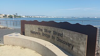
Silver Strand, or simply The Strand, is a low, narrow, sandy isthmus or tombolo 7 miles (11 km) long in San Diego County, California partially within the Silver Strand State Beach. It connects Coronado Island with Imperial Beach. Together with the Point Loma peninsula it shelters and defines San Diego Bay. State highway 75 runs the length of the strand and is a popular site for jogging and bicycling. The Silver Strand Half Marathon is run along the route each November.

Whitethorn is an unincorporated community in Humboldt County, California. It is located 9.5 miles (15 km) southwest of Garberville, at an elevation of 1024 feet, population 817. Whitethorn shares a zip code with Shelter Cove, California. It is located along California's Lost Coast. The ZIP Code is 95589.
Likely is a census-designated place in Modoc County, California. It is located near the South Fork of the Pit River 18 miles (29 km) south of the county seat of Alturas, at an elevation of 4,449 feet (1,356 m). Located 6 miles (9.7 km) north-northwest of Likely Mountain, it is somewhat sheltered from prevailing southwesterly winds, and its microclimate is noticeably drier and less stormy than surrounding areas. The ZIP Code for the community is 96116. Likely has been noted for its unusual place name.

Fleta is an unincorporated community in Kern County, California. It is located on the Southern Pacific Railroad 3.5 miles (6 km) south-southeast of Mojave, at an elevation of 2,644 feet (806 m).
Palmo is an unincorporated community in Kern County, California. It is located on the Atchison, Topeka and Santa Fe Railroad 2.5 miles (4 km) south of Wasco, at an elevation of 338 feet (103 m).

Terese is a former settlement in Kern County, California.
Terese Siding is a former settlement in Kern County, California, south-southeast of Inyokern.
Fountain is a former settlement in Mendocino County, California. It was located on the railroad 2.5 miles (4 km) south of Hopland.
Cuba is a former settlement in Merced County, California. It was located on the Atchison, Topeka and Santa Fe Railroad 2.25 miles (3.6 km) east-northeast of Atwater, at an elevation of 167 feet. Cuba still appeared on USGS maps as of 1918.
The Richmond Naval Lighter Than Air Station was a South Florida military installation about 18 miles (29 km) south of Miami, and 3.5 miles (5.6 km) west of US 1. It was an active base during World War II.