Cultural Development of Kamarupa

Last updated

Contents

Kamarupa was most a powerful and formidable kingdom in Northeast India ruled by three dynasties (Varmans, Mlechchha and Palas) from their capitals in Pragjyotishpura, Haruppeshwara and Durjaya.

Early development

Xuanzang's account from the seventh century states the people of Kamarupa worshiped the devas and did not believe in Buddhism. There were a few Buddhists who performed devotional rites in secret for fear of persecution. Shilabhadra is said to have stated that Buddhism had spread there.

Bhaskaravarman Nidhanpur inscription Nidhanpur Inscription of Bhaskar Varman.jpg
Bhaskaravarman Nidhanpur inscription

Bhaskaravarman, with tutelary deity Shiva, is said to have treated the accomplished shramanas with respect.

Kamakhya Temple
Temple of Kamakhya.jpg
Tower
A Statue of a Hindu GOD, Kamakhya Temple, Guwahati.JPG
Sculpture

Whatever that may be, although Brahmanic rites were widely prevalent amongst the populace there is no doubt that Buddhism also flourished, for it is mentioned in the "Sankara Digvijaya" that Sankaracharya, the famous leader of the Brahmanic revival, in the beginning of the ninth century A.D., came to Kumarupa in order to defeat Abhinava Gupta, the noted Buddhist scholar, in controversy. [4] About the same time, or a little earlier, Kumarila Bhatta, another Brahmanic leader, flourished in India. It is believed by some that he was a native of Kamarupa. [5]

Giuseppe Tucci states, on the authority of two Tibetan works viz "Grub To'b" and the "Bka ababs bdun ldan" that the noted Buddhist Siddha Minanatha, who was looked upon in Tibet as an avatar of Avalokiteswara, was a fisherman from Kamarupa. [6] The statement of Mahamohopadhya Pandit Haraprasad Sastri that Minanatha was a native of Bengal belonging to the "Nath" or weaver caste is evidently incorrect. [7] Minanatha is supposed to have been the author of a work known as Akulaviratantra and he is mentioned in the Sabaratantra as one of the twenty four Kapalika siddhas. [8]

It has been pointed out that Visakha Datta, the author of the well-known drama Mudrarakshasam, who flourished towards the latter part of the seventh century, very probably belonged to that part of Kamarupa which lay between the Teesta and the Kausika. [9] It find the mention of a Kamrupi pandit, named Vishnusomacharya, to whom Anantavarman granted lands. [10] This Brahman belonged to the Parasara gotra and his native village was Srangatika in Kamarupa.

Standard of architecture

Madan Kamdev Assam MK Lion.JPG
Madan Kamdev

The shrine of Pandu contains five rock-cut figures four of which represent Ganesa and one represents a female deity, probably Durga. Two more figures cut in the open rock below, facing the Brahmaputra river, represent, according to Mr. Dikshit, the sun-god and Indra respectively. [11] Numerous cuttings on rock are to be seen also on the western slope of the Kamakhya hill.

Mr. R. D. Banerji thinks that these carvings belong to the seventh or the eighth century A.D. [12] The ruins existing in or near Tezpur are much more extensive and varied in character. The Dr. Bloch conjectured that the modem civil stations of Guwahati and Tezpur stood upon large mounds " which contain the remains of two ancient cities." In 1906, while foundations were being dug for additions to the Deputy Commissioner's office in Tezpur, the excavators came upon the remains of an ancient stone building. A large number of carved and sculptured stones were discovered. The majority of then were transferred to the compounds of the European officers and the tea-planters club for the purpose of decoration. Some of them were subsequently brought to the Cole Park and arranged there.

There are two specimens in the public park at Tezpur which appear to belong to another temple of some later date. One of these is a high doorjamb and the second a slab bearing three sunken panels occupied by very crude human or divine figures. The entire collection contains only a single specimen carved in the round, a lion, presumably on an elephant. The conventional representation of the lion shows that the inhabitants of the Assam valley were not very familiar with the king of beasts. As remarked by Mr. Banerji "Assam is the only province of India the history of the architecture and sculpture of which is still practically unknown".

It is for this reason that it have made a lengthy quotation front the report of a competent authority on the subject. It is, however, in doubt whether Mr. Banerji's conjecture that the ruins in Tezpur town represent only temples is correct. The remains of the stone building dug up in the Kutchery compound may he of the palace of Vanamala which he erected in the ninth century. It cannot, however, agree with Mr. Banerji that any of the buildings mentioned by him was erected in the twelfth century for, towards the end of the tenth century, the capital Haruppeswara was, in all probability, abandoned by Brahma Pala. The buildings in Tezpur must therefore belong to the ninth century. Further, the lofty temple the ruins of which he has described in the quotation given above and which, he conjectures was a sun-temple, may be the Himalaya like temple of Hataka Sulin which Vanamala is said to have recrected. In his report for the year 1925-26. Mr. Banerji gives a full description of the Bamuni Hill ruins to the east of Tezpur town.

Relics of ancient architecture and sculpture are not confined to Guwahati and Tezpur. They are to be found in many other places. Two images were discovered on the Golaghat-Dimapur road. One of them is an image of Vishnu which is now preserved in the museum of the Kamaruppa Anusandhan Samiti. With regard to this image Mr. K. N. Dikshit writes: [13]

It is a very fine example of the ninth century art of Assam and is inscribed in characters similar to those of the Harjara inscription from Tezpur. The right hands and the feet of the image have broken off, and the halo behind the head is lost. The left upper hand holds the conch and the left lower the gada. Vishnu has all the usual ornaments, the kaustubha and srivatsa symbols, the sacred thread and the long cable-like garland reaching to the knees (vanamala). The expression of the face and the treatment of the lower lip and the crown are characteristic of the late Gupta sculpture. The inscription is engraved on the right side of the image and consists of four lines in very corrupt Sanskrit verse.

The image exhibits the Dhyana mudra and is surrounded by ararana devatas such as Durga, Ganesa and Kartikeya with the winged Garuda: below it. With regard to this image Mr. K.N. Dikshit writes that

the presence of Ganesa and Mahishamardini on the right leads to the inference that the idea was to depict Vishnu in the centre of the five gods (Panchadevata). ; The deities on the left one-should have expected to be Siva and Surya, but actually they are different. The upper figure is apparently in the attitude of Hanuman or some attendant of Vishnu while the lower one resembles an 'ascetic seated cross-legged. It is likely that the figure represents the donor as a devotee.

There is a collection of stone images and other architectural fragments preserved at the entrance of the Sub-divisional officer's residence in Sibsagar. These are believed to be the remains of a Vishnu temple, in the neighbourhood, dating approximately from the tenth to the eleventh century A. D. According to Mr. Dikshit

the sculptures follow in the main the artistic traditions of the school represented by the Tezpur and Bamuni Hill temples of Central Assam, which are assigned to the ninth and tenth centuries.

Very probably the ancient temple near Sibsagar was constructed by the Kamarupa kings of the tenth or the eleventh century and it is thus evident that even till the eleventh century the Kamarupa kings exercised their rule as far as the easternmost corner of the Assam valley. Mr. Dikshit also remarks that "the affinities of Assamese art would seem to lie more with the schools of Bihar and Orissa than with the contemporary Pala art of Bengal. This is not unnatural as of the streams of influence that have moulded the culture of Assam, the strongest current has always been from North Bihar and Mid-India". [14] The cultural affinities between Mithila and Kamarupa have already been alluded.

Another instance of the architectural and engineering skill of the people of Kamarupa in ancient times was the construction of stone bridges over rivers. There is still a small stone bridge in the western part of North Guwahati which is called Silsako. The other Silsako (stone bridge) was over a channel of the Barnadi, an important transit point from west. Bridge was destroyed by the great earthquake of 1897. It appears that this bridge was constructed without lime and mortar and such construction was no doubt necessitated by the heavy rainfall in the country and the luxuriant vegetation which attacks all masonry structures in which mortar is used. Hannay, who in 1851 saw and measured the bridge, gave a description. [15]

Copper Plate Seal of Kamarupa Kings Copper Plate Seal of Kamarupa Kings.jpg
Copper Plate Seal of Kamarupa Kings

See also

Related Research Articles

Tezpur City in Assam, India

Tezpur is a city and urban agglomeration in Sonitpur district, Assam state, India. Tezpur is located on the banks of the river Brahmaputra, 175 kilometres (109 mi) northeast of Guwahati, and is the largest of the north bank cities with a population exceeding 100,000 as per Metropolitan Census 2011.

Kamakhya Temple Hindu goddess temple in India

The Kamakhya Temple is a Sakta temple dedicated to the mother goddess Kamakhya. It is one of the oldest of the 51 Shakti Pithas. Situated on the Nilachal Hill in western part of Guwahati city in Assam, India, it is the main temple in a complex of individual temples dedicated to the ten Mahavidyas of Saktism, namely, Kali, Tara, Tripura Sundari, Bhuvaneshwari, Bhairavi, Chhinnamasta, Dhumavati, Bagalamukhi, Matangi and Kamalatmika. Among these, Tripurasundari, Matangi and Kamala reside inside the main temple whereas the other seven reside in individual temples. It is an important pilgrimage destination for Hindus and especially for Tantric worshipers.

Kamarupa kingdom based around Assam (350-1140)

Kamarupa, an early state during the Classical period on the Indian subcontinent, was the first historical kingdom of Assam.

Narakasura Founder of Bhauma dynasty of Pragjyotisha Kingdom in ancient India

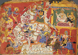
Naraka, also known as Narakasura, was a mythical asura king, the legendary progenitor of all three dynasties of Pragjyotisha-Kamarupa, and the founding ruler of the legendary Bhauma dynasty of Pragjyotisha. Though the myths about Naraka are first mentioned in the Mahabharata, later texts embellish them. According to later post-Vedic texts such as the Brahma Purana and Vishnu Purana, he was the son of Bhudevi, fathered either by the Varaha incarnation of Vishnu or Hiranyaksha. He is claimed as one who established Pragjyotisha. He was killed by Krishna and Satyabhama. His son Bhagadatta—of Mahabharata fame—succeeded him.

Varman dynasty Ruling dynasty of Kamarupa kingdom in ancient India between 350 CE - 655 CE

The Varman dynasty (350-650) was the first historical dynasty of the Kamarupa kingdom. It was established by Pushyavarman, a contemporary of Samudragupta. The earlier Varmans were subordinates of the Gupta Empire, but as the power of the Guptas waned, Mahendravarman (470-494) performed two horse sacrifices and the status of Kamarupa as independent state remained umimpaired. According to the Allahabad Prasasti, the ruler of Kamarupa was a frontier ruler (Pratyanta-nrpatis) of the great Gupta emperor.

Mlechchha dynasty

The Mlechchha dynasty ruled Kamarupa from their capital at Harruppesvar in present-day Tezpur, Assam, after the fall of the Varman dynasty. According to historical records, there were twenty one rulers in this dynasty, but the line is obscure and names of some intervening rulers are not known.

North Guwahati Neighbourhood in Kamrup Rural district, Assam, India

North Guwahati is northern part of the city of Guwahati and a town area committee in Kamrup Rural district in the Indian state of Assam.This town abounds in historical places and picnic spots. National Highway 27 passes through North Guwahati. Amingaon neighbourhood is district headquarter of Kamrup Rural district.

Fine Arts of Assam has extremely rich tradition.

Tourism in Assam

Assam is the main and oldest state in the North-East Region of India and serves as the gateway to the rest of the Seven Sister States. The land of red river and blue hills, Assam comprises three main geographical areas: the Brahmaputra Valley which stretching along the length of the Brahmaputra river, the Barak Valley extending like a tail, and the intervening Karbi Plateau and North Cachar Hills. Assam shares its border with Meghalaya, Arunachal Pradesh, Nagaland, Manipur, Tripura, Mizoram and West Bengal; and there are National Highways leading to their capital cities. It also shares international borders with Bhutan and Bangladesh and is very close to Myanmar. In ancient times Assam was known as Pragjyotisha or Pragjyotishpura, and Kamarupa.

Lower Assam Region in India

Lower Assam is a region situated in Western Brahmaputra Valley encompassing undivided Kamrup and Goalpara regions. Soon after the formal creation of the British districts in 1833, Lower Assam denoted one of the five initial districts that were created west of the Dhansiri river, which, along with the six paraganas, became a single district of Kamrup in 1836. It was home to the kingdom of Kamarupa, ruled by Varman's and Pala's from their capital's Pragjyotishpura (Guwahati) and Durjaya. Today Guwahati is the largest city of North-East India while Dispur, the capital of Assam, is within the town.

Sri Surya Pahar

Sri Surya Pahar is located about 12 km southeast of Goalpara, about 132 km northwest of Guwahati, is a significant but relatively unknown archaeological site in Assam, India. Goalpara is the nearest city from the site. The site is a hilly terrain where several rock-cut Shivalingas, votive stupas and the deities of Hindu, Buddhist and Jain pantheon are scattered in an area of about one km. The site is centered on the hills (Pahar) of Sri Surya which is profusely filled up with Shiva Lingas (Lingam). The popular belief is that 99999 Shiva Lingas were engraved here by Vyasa in order to build up a second Kashi and once it was one of the holiest pilgrimage sites in the region. There is no historical evidence exactly how many Lingams once dotted in these hills, but still there are hundreds of them, from tiny to large in size, scattered everywhere at the foot of the hill and covering the extensive area after centuries of neglect and pilferage. The exact figure of the Lingas in the hill is yet to be counted scientifically.

Kalyanavarman (Varman dynasty) King of Kamarupa

Kalyanavarman ruled Kamarupa from the Varman dynasty for the period of 422-446 A.D. He was the son of Kamrupi king Balavarman and queen Ratnavati. He married Gandharvavati and had a successor to throne named Ganapativarman.

Narayanavarman King of Kamarupa

Narayanavarman ruled Kamarupa from the Varman dynasty for the period 494-518, was son of Kamarupi King Mahendravarman and Queen Suvrata. He married Devavati and had successor to throne named Bhutivarman.

Susthitavarman Varman dynasty

Susthitavarman (590-595) was a ruler of Kamarupa. He was a son of Sthitavarman and Queen Nayanadevi.

Go Pala King of Kamarupa

Go Pala was successor and son of Indra Pala and his queen Rajya Devi, of Pala Dynasty of Kamarupa Kingdom, who ruled for the period 990-1015 A.D.

Harsha Pala King of Kamarupa

Harsha Pala was son of Go Pala, the ruler of Pala Dynasty of Kamarupa Kingdom and Queen Nayana. He ruled for the period 1015-1035 A.D.

Kamrupi literature is the literature written in the modern Kamrupi dialects of Assamese language.

Silsako Bridge in India

Silsako was an ancient stone bridge over a channel of river Barnadi in Hajo, Kamrup. As the channel changed its course over time, now the bridge is stranded in the middle of a small lake. It was an important transit route in ancient and medieval times. Many invaders like Muhammed Bin Bukhtiyar entered into Kamarupa in the year 1205-06 AD, and crossed the bridge Silsako. This historical bridge sustained damage in the 1897 Assam earthquake.

Hayagriva Madhava Temple

Hayagriva Madhava Temple is situated on the Monikut hill. The hill is situated in Hajo of Kamrup District in Assam, India. Which is around 30 km to west of Guwahati. The Kalika Purana composed in the 11th century CE in Kamarupa talks about the origin of this form of Vishnu and his final establishment in the hill of Monikut, where the present temple is located. The present temple structure was constructed by the King Raghudeva Narayan in 1583. According to some historians the King of Pala dynasty constructed it in 10th century. It is a stone temple and it enshrines an image of Hayagriva Madhava. Some Buddhists believe that the Hayagriva Madhava temple, best known in the group of Hindu temples, is where the Buddha attained Nirvana. At this imposing temple, the presiding deity is Vishnu, worshipped in the sanctum sanctorum as an idol carved of black stone. Four other stone idols are also in worship as subsidiary deities.

Kamapitha

Kamapitha is one of the four Kamarupa Pithas, the geographical divisions of ancient Kamarupa. Dineshchandra Sircar points out that these divisions are not found in the Kamarupa inscriptions and that they might be fabrications from late medieval sources, such as 16th-century work Yogini Tantra gives the boundaries of Kamapitha and other three pithas, the same work which gives boundaries of ancient Kamrup kingdom as well. The eastern border of Kamarupa was the temple of the goddess Tamreshvari near present-day Sadiya

References

  1. "639 Identifier Documentation: aho – ISO 639-3". SIL International (formerly known as the Summer Institute of Linguistics). SIL International. Retrieved 29 June 2019. Ahom [aho]
  2. "Population by Religious Communities". Census India – 2001. Ministry of Home Affairs, Government of India. Retrieved 1 July 2019. Census Data Finder/C Series/Population by Religious Communities
  3. "Population by religion community – 2011". Census of India, 2011. The Registrar General & Census Commissioner, India. Archived from the original on 25 August 2015.
  4. C.N Krishnaswami Aiyar, Sri Sankaracharya; His life and times, p.56
  5. C.N Krishnaswami Aiyar, Sri Sankaracharya; His life and times, p.26
  6. J.P.A.S.B (New Series) - vol. XXVI (1930), no.1, p.133-141
  7. M.M Pandit H.P Shastri, Bauddha Gan O Doha
  8. J.P.A.S.B, vol.XXVI (1930), p.133-141
  9. J.P.A.S.B, vol.XXVI, p.241-245
  10. R.D Banerji, History of Orissa - vol. I, p.233-241
  11. Annual Report of the Archaeological Survey of India(1923-24), p.80-81
  12. Annual Report, A.S.I (1924-25), p.100-101
  13. Annual report of Archaeological Survey of India, (1923-24), p.82
  14. Annual Report of Archaeological Survey of India (1927-28), p.112-113
  15. J.A.S.B - no.IV (1851), p.290-294

Further reading