Current River, Thunder Bay, Ontario

Last updated
Current River
Boulevard Lake Thunder Bay And Dam.jpg
Looking south at Boulevard Lake
Population
4,780
Ward
Current River
Red pog.svg
Map of Thunder Bay.svg
Location of Current River in Thunder Bay

Current River is a neighbourhood located north east of Port Arthur in the city of Thunder Bay, Ontario. It is separated from the main urban area of Thunder Bay by the Current River Greenway, a large parkland along the river after which the neighbourhood was named. It is home to approximately 4,780 people and has an ageing and declining population. [1]

Contents

Current River is located entirely in Current River Ward and is represented on Thunder Bay City Council by Andrew Foulds.

History

An apartment block Current River Apartment Block.jpg
An apartment block

Development of Current River began after World War II, and many homes in the neighbourhood are "Victory Homes", a post-war building style that allowed fast manufacture of single-family dwellings. Development in the neighbourhood progressed northward, and as one travels further north Victory Homes become less common, being replaced with more contemporary building styles. A small cluster of highrise apartments is located beside an outcrop of the Canadian Shield in the southernmost portion of the residential neighbourhood, and offers its residents a view of the Current River Greenway and Thunder Bay.

Geography

Current River is located in the northeast portion of Thunder Bay. It is located east of the Current River and Boulevard Lake and north of Lake Superior. The land inclines as one travels north from the Lake Superior and west from Hodder Avenue.

Economy

Port Arthur shipyard Port Arthur Shipbuilding Company Crane.JPG
Port Arthur shipyard
Grain elevators Current River Grain Elevators.jpg
Grain elevators

Along the shores of Lake Superior to the south and east of the neighbourhood is an abundance of industries. Separated from the main neighbourhood by Hodder Avenue and the Canadian Pacific Railway and Canadian National Railway mainlines is the Port Arthur Shipbuilding Company (PASCO) drydock and shipyard, which has been operating since 1909, [2] and the Thunder Bay Fine Papers mill, formerly Cascades. Further east is the abandoned Smurfit-Stone factory, and the Bare Point water treatment plant which is the main source of drinking water in Thunder Bay. Grain elevators located south of the Current River dominate the view toward the lake.

Current River is home to a small selection of commercial businesses. Mainly located along Hodder Avenue near Arundel Street, the neighbourhood is home to a strip mall with a pharmacy and grocery store, a convenience store and gas station, and several restaurants and coffee shops. Most businesses in the neighbourhood are locally owned.

Transportation

Grenville Avenue Looking South on Grenville Avenue in Current River.jpg
Grenville Avenue

The main roads in the neighbourhood are Arundel Street, an east–west arterial road that bridges the Current River and connects the community to the Shuniah neighbourhood. Hodder Avenue is the main north–south thoroughfare and forms the backbone of the community's small commercial strip. Grenville Avenue, which is separated into two sections by the Current River Playfield, formed the neighbourhood's original business corridor.

Thunder Bay Transit route 1 Mainline-Current River makes a counterclockwise loop through the neighbourhood and brings residents south to downtown Port Arthur.

Education

Current River is home to two schools. Claude Garton Public School is part of the Lakehead Public Schools system and offers French immersion classes grades JK-8, and is located in the southern part of the neighbourhood. St. Paul which is grades JK-6 Catholic School is located in the northern part of Current River, and is part of the Thunder Bay Catholic District School Board. Public school students from Current River attend Superior Collegiate and Vocational Institute, and Catholic students attend St. Ignatius, located on the other side of Boulevard Lake.

Recreation

Current River is the location of the largest park in Thunder Bay, the Current River Greenway. The 260 hectares (640 acres) park includes Boulevard Lake, one of the Thunder Bay's most popular summer destinations. The Current River Playfield, located in the middle of Current River, includes a community centre, arena, baseball diamonds, soccer fields, and seasonal ice rinks.

The municipally operated Strathcona Golf Course is located to the east of Current River, and is an 18-hole, 72-par course. [3] Centennial Park, a recreation of a 20th-century logging camp, is located northwest of the neighbourhood. The Terry Fox Memorial and Lookout is northeast of the neighbourhood, located along Highway 11/17. It commemorates Terry Fox's Marathon of Hope and offers panoramic views of the lake.

Related Research Articles

<span class="mw-page-title-main">Thunder Bay</span> City in Ontario, Canada

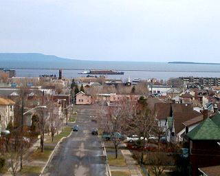
Thunder Bay is a city in and the seat of Thunder Bay District, Ontario, Canada. It is the most populous municipality in Northwestern Ontario and the second most populous municipality in Northern Ontario; its population is 108,843 according to the 2021 Canadian Census. Located on Lake Superior, the census metropolitan area of Thunder Bay has a population of 123,258 and consists of the city of Thunder Bay, the municipalities of Oliver Paipoonge and Neebing, the townships of Shuniah, Conmee, O'Connor, and Gillies, and the Fort William First Nation.

<span class="mw-page-title-main">The Beaches, Toronto</span> Neighbourhood in Toronto, Ontario, Canada

The Beaches is a neighbourhood in Toronto, Ontario, Canada. It is so named because of its four beaches situated on Lake Ontario. It is located east of downtown within the "Old" City of Toronto. The approximate boundaries of the neighbourhood are from Victoria Park Avenue on the east to Kingston Road on the north, along Dundas Street to Coxwell Avenue on the west, south to Lake Ontario. The Beaches is part of the east-central district of Toronto.

<span class="mw-page-title-main">Current River (Ontario)</span> River in Ontario, Canada

The Current River is a river in the City of Thunder Bay and Unorganized Thunder Bay District in Thunder Bay District, Northwestern Ontario, Canada. The river is in the Great Lakes Basin and is a tributary of Lake Superior. The river's name comes from the French "Rivière aux courants", referring to the river's currents.

<span class="mw-page-title-main">Riverdale, Toronto</span> Neighbourhood in Toronto, Ontario, Canada

Riverdale is a large neighbourhood in Toronto, Ontario, Canada. It is bounded by the Don River Valley to the west, Danforth Avenue and Greektown to the north, Jones Avenue, the CN/GO tracks, Leslieville to the east, and Lake Shore Boulevard to the south.

Port Arthur was a city in Northern Ontario, Canada, located on Lake Superior. In January 1970, it amalgamated with Fort William and the townships of Neebing and McIntyre to form the city of Thunder Bay.

The Millionaires' Mile, Millionaires' Row, Billionaires Row, Golden Mile or Alpha Street are the exclusive residential neighborhoods of various cities, often along one scenic strip such as a riverside or hilltop drive, or a wide city boulevard.

<span class="mw-page-title-main">Thunder Bay—Superior North</span> Federal electoral district in Ontario, Canada

Thunder Bay—Superior North is a federal electoral district in Ontario, Canada, that has been represented in the House of Commons of Canada since 1976.

The Thunder Bay Expressway, originally known as the Lakehead Expressway is a high-capacity at-grade suburban limited-access road around the western side of Thunder Bay in the Canadian province of Ontario. The 15.3 km (9.5 mi) route travels in a generally north–south direction on the city's west side. It is signed as part of Highway 61 at its southern end, and as part of the concurrent route of Highway 11 and Highway 17. The expressway features several at-grade intersections between its southern terminus at Arthur Street West and the Harbour Expressway and its northeastern terminus at Hodder Avenue.

<span class="mw-page-title-main">Gwaʼsala-ʼNakwaxdaʼxw Nations</span>

The Gwa'Sala-Nakwaxda'xw Nations are a union of two Kwakwaka'wakw peoples in a band government based on northern Vancouver Island in British Columbia, Canada, whose main reserve community is near the town of Port Hardy in the Queen Charlotte Strait region of the Central Coast region of British Columbia, Canada. The band government is a member of the Kwakiutl District Council and, for treaty negotiation purposes, the Winalagalis Treaty Group which includes three other members of the Kwakiutl District Council.

<span class="mw-page-title-main">Garneau, Edmonton</span> Neighbourhood in Edmonton, Alberta, Canada

Garneau is one of the oldest neighbourhoods in the city of Edmonton, Canada. Prior to 1912, it was part of the City of Strathcona. It is named after one of its first inhabitants, Laurent Garneau, a former Manitoba Métis rebel and Hudson's Bay Company employee who with his wife and family settled there around 1874.

<span class="mw-page-title-main">McKernan, Edmonton</span> Neighbourhood in Edmonton, Alberta, Canada

McKernan is a neighbourhood located in southwest Edmonton, Alberta, Canada. It is named for John McKernan, a prominent businessman in the City of Strathcona whose parents' farm was located there beginning in the late 1870s. "Jack" McKernan (1870-1918) was the force behind the Princess Theatre, which still stands on Whyte Avenue. The McKernan-Belgravia LRT station is located in the west portion of the neighbourhood at the northwest corner of 114 Street and 76 Avenue, adjacent to neighbouring Belgravia. The community is near to both the University of Alberta and Old Strathcona.

<span class="mw-page-title-main">Current River Greenway</span> Public greenspace in Thunder Bay, Ontario

The Current River Greenway is a 263 hectare greenway located in Current River neighbourhood in the north end of Thunder Bay, Ontario along the Current River.

<span class="mw-page-title-main">Transportation in Thunder Bay, Ontario</span> Overview of transportation in Thunder Bay, Ontario

Transport in Thunder Bay is essential to trade, which has always been the backbone of the economy, beginning with Fort Kaministiquia in 1717. When the area was first settled its many waterways were used by the voyagers and Coureur des bois to trade their goods.

<span class="mw-page-title-main">Thunder Bay—Superior North (provincial electoral district)</span> Provincial electoral district in Ontario, Canada

Thunder Bay—Superior North is a provincial electoral district in Ontario, Canada, that has been represented in the Legislative Assembly of Ontario since 1999.

<span class="mw-page-title-main">Downtown Fort William, Ontario</span>

Downtown Fort William, also known as Downtown Thunder Bay South or the South Core, is the urban core of the former city of Fort William, the southern half of Thunder Bay, Ontario. It is centred on Victoriaville Civic Centre, an indoor shopping mall and civic centre built as part of an urban renewal project in the 1980s. It is separated from the Kaministiquia River by the Canadian Pacific Railway line, and its topography is relatively flat.

<span class="mw-page-title-main">Gwynns Falls Trail</span>

Gywnns Falls Trail is a 15-mile (24 km) series of hiking and bicycling trails inside Baltimore, Maryland, named for the Gwynns Falls, whose course it follows, and the surrounding Gwynns Falls Leakin Park it passes through. The trail uses unique alignments, sidepaths on existing streets, and on-street sections. The trail consists of one 10.75-mile (17.30 km) mainline, plus a number of branches, including the Middle Branch Trail, the Hutton Trail, and the Dickeyville Trail. All of these trails carry signage designating them as the Gwynns Falls Trail; their individual names are designated on the mile markers designating their route. The entirety of the Middle Branch Trail, as well as the section of the mainline trail east of the Middle Branch Trail's northern terminus, are part of the East Coast Greenway.

References

  1. Statistics Canada Census Tract Profile for 0021.00 (CT) Thunder Bay. This census tract includes the entire neighbourhood of Current River and the sparsely populated areas north and east of the neighbourhood.
  2. Index of Business and Labour Holdings - Port Arthur Shipbuilding Company fonds Archived 2008-07-05 at the Wayback Machine . Thunder Bay Historical Museum Society. Retrieved on 11 February 2008.
  3. Golf Thunder Bay - Strathcona Archived 2007-10-27 at the Wayback Machine . Retrieved on 11 February 2007.

48°28′00″N89°11′00″W / 48.46667°N 89.18333°W / 48.46667; -89.18333