
Tyrrell County is a county located in the U.S. state of North Carolina. As of the 2020 census, the population was 3,245, making it the least populous county in North Carolina. Its county seat is Columbia. The county was created in 1729 as Tyrrell Precinct and gained county status in 1739. Tyrrell County is included in the Kill Devil Hills, NC, Micropolitan Statistical Area, which is also included in the Virginia Beach-Norfolk, VA-NC Combined Statistical Area.

Dare County is the easternmost county in the U.S. state of North Carolina. As of the 2020 census, the population was 36,915. Its county seat is Manteo. Dare County is named after Virginia Dare, the first child born in the Americas to English parents, who was born within the county's current borders. Founded in 1870 from parts of Tyrrell, Currituck and Hyde counties, it consists of a large segment of the Outer Banks of North Carolina, along with Roanoke Island and a peninsula of land attached to the mainland. Most of the county consists of a string of resort communities along the Outer Banks. While lightly populated by year-round residents, the population swells during the summer with vacationers.

Currituck County is the northeastern most county in the U.S. state of North Carolina. As of the 2020 census, the population was 28,100. Its county seat is Currituck. The county was formed in 1668 as a precinct of Albemarle County and later gained county status in 1739. The name is "traditionally said to be an indigenous word for wild geese; Coratank." Currituck County is included in the Virginia Beach-Norfolk-Newport News, VA-NC Metropolitan Area. It is in the northeastern section of the state and is bounded by the Atlantic Ocean, Currituck Sound, Camden County, Dare County and the Commonwealth of Virginia. Currituck Court House, mentioned as early as 1755, was the name of the county seat. Today the words "Court House" have been dropped and only Currituck is used as the town name.

Corolla is an unincorporated community located in Poplar Branch township, Currituck County, North Carolina, United States, along the northern Outer Banks. It has a permanent population of approximately 500 people; during the summer vacation season, the population surges into the thousands. Corolla is home to the Currituck Beach Lighthouse, one of the seven North Carolina coastal lighthouses.

Duck is a town in Dare County, North Carolina, United States. As of the 2020 census, the population was 746. During the peak vacation season, starting after Memorial Day, the population increases to over 20,000. Duck is the northernmost incorporated town in Dare County and the Outer Banks' newest town, incorporated on May 1, 2002. Duck offers visitors outdoor recreational activities, summer events and concerts, watersports, fine dining, shopping, art galleries, and a nationally known jazz festival, as well as the 11-acre (4.5 ha) Town Park and soundside boardwalk.

False Cape State Park is a 4,321-acre (17.49 km2) state park located on the Currituck Banks Peninsula, a one-mile-wide (1.6 km) barrier spit between the Back Bay of the Currituck Sound and the Atlantic Ocean, within the city of Virginia Beach, adjacent to the state border with North Carolina, and just north of Mackay Island National Wildlife Refuge.

The Outer Banks are a 200 mi (320 km) string of barrier islands and spits off the coast of North Carolina and southeastern Virginia, on the east coast of the United States. They line most of the North Carolina coastline, separating Currituck Sound, Albemarle Sound, and Pamlico Sound from the Atlantic Ocean. A major tourist destination, the Outer Banks are known for their wide expanse of open beachfront and the Cape Hatteras National Seashore. The seashore and surrounding ecosystem are important biodiversity zones, including beach grasses and shrubland that help maintain the form of the land.

Coinjock is an unincorporated community and census-designated place (CDP) in Currituck County, North Carolina, United States. As of the 2010 census it had a population of 335. It is located on U.S. Route 158 between Barco and Grandy, about 20 miles (32 km) south of the Virginia state line, and is at mile marker 50 on the southern portion of the Albemarle and Chesapeake Canal, on the Intracoastal Waterway. Church's Island to the east of Coinjock in the Currituck Sound has a village called Waterlily, which uses the postal address of Coinjock as well. The island's name is due to a decayed church that was once a landmark of the tiny community. Coinjock is bordered by Currituck Sound to the east; the North River lies to the west. Its ZIP code is 27923.
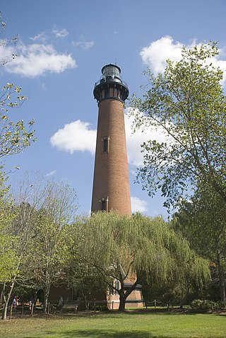
The Currituck Beach Light is a lighthouse located on the Outer Banks in Corolla, North Carolina. The Currituck Beach Light was added to the National Register of Historic Places on October 15, 1973.

The Albemarle and Chesapeake Canal was built by a corporation in 1856-1860 to afford inland navigation between the Chesapeake Bay and the Albemarle Sound. It is really two canals, thirty miles (50 km) apart, one eight and one-half miles (13.7 km) long, connecting the Elizabeth River with the North Landing River in Virginia, and the other five and one-half miles (8.9 km) long, connecting the Currituck Sound with the North River in North Carolina.

Currituck Sound is a lagoon located in northeastern part of North Carolina and extreme southeastern Virginia.
Currituck is an unincorporated community in extreme northeastern North Carolina, United States. Situated along the Currituck Sound, it serves as the county seat for Currituck County. Currituck is part of the Inner Banks region and is one of the state's few unincorporated county seats. The community harbors the Knotts Island Ferry, which provides free shuttles across the sound to Knotts Island. North Carolina Highway 168 and Courthouse Road are the community's most prominent roads. The Currituck Beach Lighthouse is not located on mainland Currituck but is located across the sound on the Outer Banks.
Bodie Island is a long, narrow barrier peninsula that forms the northernmost portion of the Outer Banks. The land that is most commonly referred to as Bodie Island was at one time a true island, but in 1811 Roanoke Inlet, which had separated it from the Currituck Banks in the north, closed. As a result, the Currituck Banks and Bodie Island are now one contiguous peninsula, joined at the Nags Head area, where the inlet once flowed. Today, either name can be used to refer to peninsula as a whole, but both portions colloquially retain their historical names.
Poplar Branch is an unincorporated community in Currituck County, North Carolina, United States. It lies at an elevation of 13 feet (4.0 m).

This list includes properties and districts listed on the National Register of Historic Places in Currituck County, North Carolina. Click the "Map of all coordinates" link to the right to view an online map of all properties and districts with latitude and longitude coordinates in the table below.
The Baum Site (31Ck9) is one of the most prominent Middle and Late Woodland Period sites of the Colington Phase in the state of North Carolina. It is located north of Poplar Branch in Currituck County, North Carolina. This phase, marked by cultures of the Algonkian peoples, aligns with the Late Woodland period in North Carolina, occurring during English explorations between 1584 and 1587, and permanent settlement at 1650. This village is what the first English explorers encountered when entering the coastal region. The site contained ossuaries and evidence for a coastal village adaptation. The site was registered with the National Register of Historic Places on December 8, 1982, after testing and excavations in 1972 and 1973 by David Sutton Phelps, who was an archaeologist at East Carolina University. The site is suffering from erosion due to wave action. After the initial discovery, which was the result of erosion uncovering of remains, Phelps claimed, “this will provide the first glimpse of a coastal village of this type in the state”. A residential subdivision, Currituck Crossing, is now located on the Baum site. https://web.archive.org/web/20160617035403/http://co.currituck.nc.us/pdf/board-of-commissioners-minutes-2013/boc-minutes-13nov04.pdf.
Culong, also known as the Thomas Cooper Ferebee House and Forbes House, is a historic home located near Shawboro, Currituck County, North Carolina. It was built in 1812, and is a two-story, three bay by three bay, Federal style frame dwelling with a gable roof. It has two wing additions and a one-story front portico. Also on the property are two contributing outbuildings and family cemetery.

Currituck County Courthouse and Jail is a historic courthouse and jail located at Currituck, Currituck County, North Carolina. The original two-story section of the courthouse was built about 1842, enlarged in 1897, and a rear wing was added in 1952. The 1897 remodeling added a second floor to the original one-story wings and Classical Revival style design elements. The jail was built about 1857, and is a two-story, rectangular building with 32 inch thick brick walls. It is one of the oldest extant jails in North Carolina.
The Flyway Club is a historic shooting club at 221 Marsh Causeway in Knotts Island, North Carolina. Located on more than 400 acres (160 ha) facing Currituck Sound on the west side of Knotts Island, it is one of the oldest surviving fowl hunting clubs in the state. Its main lodge was built about 1920, and rebuilt in a near replica in 1960 after being destroyed by fire. The lodge also includes a large U-shaped farm building, also built about 1920, that housed the club staff and farming equipment. The club was established by Ogden Mills Reid, and remained in the Reid family until 2013, when it was acquired by the Conservation Fund.


