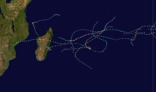
The 1995–96 South-West Indian Ocean cyclone season was a moderately active season that included Cyclone Bonita, which was the first known tropical cyclone to cross from the southern Indian Ocean into the southern Atlantic Ocean. Tropical activity lasted for about six months from the middle of November 1995 to early May 1996. The first storm, Intense Tropical Cyclone Agnielle, formed in the adjacent Australian basin on November 16 and later reached peak winds in the south-west Indian Ocean. The next named storm after Agnielle was Bonita, which formed in early January and killed 42 people. The basin was most active in February, with two tropical cyclones, or the equivalent of a minimal hurricane, as well as a severe tropical storm. The first of these three was Doloresse, which killed 67 people due to a shipwreck in the Comoros. The next storm was Cyclone Edwige, which caused heavy crop damage on Mauritius before looping along the east coast of Madagascar. In March, both Cyclone Flossy and Tropical Storm Guylianne passed near the Mascarene Islands, producing heavy rainfall and gusty winds.

The 1999–2000 South-West Indian Ocean tropical cyclone season was the first on record in which two storms – Leon–Eline and Hudah – struck Mozambique at tropical cyclone intensity, or with maximum sustained winds of at least 120 km/h (75 mph). The most notable storm of the season was Eline, which was the third longest-lasting storm on record in the basin. It lasted for 29 days while traversing the southern Indian Ocean, making the strongest landfall in decades along eastern Madagascar in late February. The storm was the first in a series of three storms that struck the country in early 2000, along with Gloria in March and Hudah in April. Collectively, the three storms killed at least 316 people. The season started on November 1, 1999, and ended for most of the basin on April 30, 2000; for Mauritius and the Seychelles, the season continued until May 15. These dates conventionally delimit the period of each year when most tropical cyclones form in the basin.

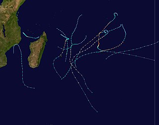
The 1997–98 South-West Indian Ocean cyclone season was fairly quiet and had the latest start in 30 years. The first tropical disturbance originated on January 16, although the first named storm, Anacelle, was not upgraded until February 8, a record late start. The last storm to dissipate was an unusually late tropical depression in late July. Many of the storms suffered from the effects of wind shear, which contributed to there being only one tropical cyclone – equivalent to a minimal hurricane. The season also occurred during a powerful El Niño.

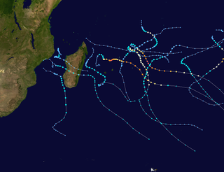
The 2006–07 South-West Indian Ocean cyclone season featured the second-most intense tropical cyclones for a season in the tropical cyclone basin, only behind the 2018–19 season. The basin contains the waters of the Indian Ocean south of the equator and west of 90°E. Météo-France's meteorological office in Réunion (MFR), the official Regional Specialized Meteorological Center for the South-West Indian Ocean, tracked 15 tropical disturbances, of which eleven attained gale-force winds. The season began in October 2006 with a short-lived tropical disturbance, followed by Anita in November, which was the first named storm of the season. Cyclone Bondo was the first of six intense tropical cyclones, which took a rare track through the southern Seychelles before making landfall on northwest Madagascar, killing 11 people. Severe Tropical Storm Clovis lasted from December 2006 to January 2007; it struck eastern Madagascar, killing four people.

The 2002–03 South-West Indian Ocean cyclone season was one of the longest lasting and the third-most active season in the South-West Indian Ocean. Storms during the season impacted the Mascarene Islands, Seychelles, Madagascar, and countries in south-eastern Africa. The season began early when an unnamed tropical storm struck Seychelles in September, becoming the most damaging storm there in 50 years. The next system, Atang, was the first named storm of the season, but was only a tropical depression; it was named due to the threat to an outer island of Mauritius. Atang later struck Tanzania in a climatologically unusual area in November, resulting in unconfirmed deaths of fishermen. The first named storm to reach tropical storm intensity was Boura, which brushed the Mascarene Islands with gusty winds and rainfall. In December, Cyclone Crystal threatened to strike Mauritius but instead veered eastward, and later, Tropical Storm Delfina lasted from late December through early January 2003. Delfina damaged or destroyed thousands of houses in Mozambique and Malawi, killing 54 people.

The 1990–91 South-West Indian Ocean cyclone season was fairly quiet, although activity began early and the final named storm formed at a record late date. There were seven named storms classified by the Météo-France office (MFR) on Réunion, as well as three depressions; an additional depression was classified by the Joint Typhoon Warning Center (JTWC), an unofficial warning agency. The JTWC tracked storms in both September and October, although neither affected land. In late November, another short-lived depression formed in the northeastern portion of the basin. Activity remained minimal until January, when Tropical Storm Alison formed in the eastern portion of the basin. Later in the month, Cyclone Bella became the strongest storm of the season, reaching 10‑minute maximum sustained winds of 155 km/h (96 mph). It passed near the island of Rodrigues, becoming the worst cyclone there in 20 years and killing half of the population of one endangered species. Bella also likely caused a cargo ship to go missing with 36 people on board. Three storms developed in short succession in the second half of February. Cyclone Cynthia developed rapidly in the Mozambique Channel on February 16 and struck western Madagascar, killing 36 people and ruining local rice harvests. A residual trough after Cynthia dissipated spawned Tropical Storm Debra, which looped in the Mozambique Channel. Toward the end of the month, Tropical Storm Elma exited the basin into the adjacent Australian region, only to re-enter the south-west Indian Ocean and dissipate. Long-lived Cyclone Fatima originated in the Australian basin in late March and changed directions before becoming extratropical. On April 2, a tropical depression struck eastern Madagascar, killing 18 people. The final storm, Gritelle, was named on June 10, the latest on record.

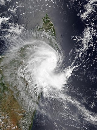
Intense Tropical Cyclone Geralda was a powerful tropical cyclone that caused catastrophic damage in Madagascar in late January 1994, among the strongest to hit the country. It was also the most intense tropical cyclone worldwide in 1994. Cyclone Geralda originated from an area of low pressure over the Indian Ocean on 25 January. Over the following few days, the depression underwent gradual intensification, reaching its peak intensity with ten-minute sustained winds of 205 km/h (127 mph) on 31 January. It eventually made landfall near Toamasina, Madagascar after weakening from its peak intensity, and substantially weakened within hours of moving onshore. By 5 February, Geralda had degenerated into a land depression, and became extratropical three days later. Geralda's remnants dissipated on 12 February.
The 1994–95 South-West Indian Ocean cyclone season was fairly active, with storms forming regularly from October through April. It was much less damaging than its predecessor, and most of the storms in the season remained over water or only brushed land. The first system was Tropical Depression A1, which formed in October and passed north of Madagascar. The first named storm was Albertine, which formed on November 23 in the northeastern portion of the basin and became one of three intense tropical cyclones. The last storm was Marlene, which was also an intense tropical cyclone and dissipated on April 11.

Intense Tropical Cyclone Nadia was a powerful tropical cyclone that struck both Madagascar and Mozambique in March 1994. It formed on 16 March and moved westward for the first ten days of its duration. Warm waters and low wind shear allowed for the storm to gradually strengthen. After developing a well-defined eye, Nadia intensified to reach winds of 175 km/h early on 22 March, according to Météo-France (MF). In contrast, the Joint Typhoon Warning Center (JTWC) estimated winds of about 220 km/h. On 23 March, the cyclone struck northern Madagascar, causing flooding and localized damage where it moved ashore. There were 12 deaths in the country. Nadia emerged into the Mozambique Channel as a weakened storm, although it reintensified slightly before making landfall in northeastern Mozambique on 24 March. The storm turned southward through the country, emerging over water on 26 March. It turned to the northeast and meandered over waters before dissipating on 1 April.

Intense Tropical Cyclone Ernest was one of two intense tropical cyclones in the 2004–05 South-West Indian Ocean cyclone season. The eighth tropical disturbance of the season, Ernest formed from a persistent area of thunderstorms in the central Indian Ocean. It initially moved southwestward, intensifying into Tropical Storm Ernest on January 20 while moving into the Mozambique Channel. After hitting Mayotte, the storm quickly intensified to reach peak winds of 165 km/h off the western coast of Madagascar. Ernest weakened slightly before striking the southwest portion of that country on January 23, producing widespread flooding and gusty winds. The next day the cyclone became extratropical before dissipating on January 25.

Intense Tropical Cyclone Japhet was a damaging tropical cyclone that affected southeast Africa in March 2003. It developed on February 25 near the southwest coast of Madagascar, and initially moved to the northwest before turning to the southwest. With favorable conditions for development, Japhet quickly intensified in the Mozambique Channel, reaching maximum winds of 175 km/h (109 mph), sustained over 10 minutes. After stalling briefly, the cyclone turned to the northwest, weakening slightly before striking Mozambique just south of Vilankulo on March 2. Japhet slowly weakened while progressing inland, dissipating over Zambia on March 6.
The 2014–15 South-West Indian Ocean cyclone season was an above average event in tropical cyclone formation. It began on November 15, 2014, and ended on April 30, 2015, with the exception for Mauritius and the Seychelles, for which it ended on May 15, 2015. These dates conventionally delimit the period of each year when most tropical and subtropical cyclones form in the basin, which is west of 90°E and south of the Equator. Tropical and subtropical cyclones in this basin are monitored by the Regional Specialised Meteorological Centre in Réunion.

Tropical Cyclone Filao was a moderately intense tropical cyclone that caused widespread flooding in Mozambique in 1988. First classified as a tropical depression north of Madagascar, the system moved southwest, crossing the northern part of the nation before entering the Mozambique Channel on 27 February, where it began to deepen. Later that day, the depression was upgraded into a moderate tropical storm. Two days later, Filao attained severe tropical storm intensity as it began to stall. On 1 March, the storm reached cyclone intensity just before turning west. Later that day, Filao attained peak intensity, with winds of 135 km/h (85 mph) and a minimum barometric pressure of 954 mbar (hPa); 28.17 inHg. Within 24 hours, however, the system moved ashore near Quelimane in Central Mozambique, and several hours later, Filao dissipated inland.
Very Intense Tropical Cyclone Hudah was a powerful and destructive tropical cyclone that affected Southeast Africa in April 2000. It was the last in a series of three cyclones that impacted Madagascar during the year. Hudah first developed as a disturbance embedded within the monsoon trough on 22 March, within the Australian region cyclone basin. Moving westward as the result of a strong subtropical ridge to its south, the storm quickly intensified, and reached Category 2 cyclone intensity on 25 March before entering the Southwest Indian cyclone basin. For various reasons that remain unknown, the cyclone was only designated a name by the time it had crossed into the area of responsibility of the Regional Specialized Meteorological Center in Réunion. Nonetheless, Météo-France (MFR) assigned the name Hudah to the cyclone. An eye formed, and the storm intensified into a tropical cyclone on 27 March well to the southeast of Diego Garcia. On 1 April, the MFR upgraded it to a very intense tropical cyclone, estimating peak 10-minute winds of 225 km/h (140 mph). By contrast, the Joint Typhoon Warning Center (JTWC) estimated 1-minute winds of 235 km/h (146 mph). At this time, the MFR estimated the pressure to have been 905 hPa (mbar), making Hudah the most intense tropical cyclone worldwide in 2000. Cyclone Hudah maintained peak winds until making landfall just southeast of Antalaha, Madagascar on 2 April. It weakened greatly over land, but re-attained tropical cyclone status on 5 April after moving over the Mozambique Channel. Hudah reached 10-minute winds of 160 km/h (99 mph) by the time it made landfall on Mozambique near Pebane, Mozambique, on 8 April, and dissipated by the next day.

Intense Tropical Cyclone Kamisy was considered the worst tropical cyclone to affect northern Madagascar since 1911. A tropical disturbance formed near Diego Garcia on 3 April 1984 and subsequently moved westward, intensifying into a moderate tropical storm two days later. Given the name Kamisy, the storm gradually intensified into an intense tropical cyclone by 9 April. Kamisy reached winds of 170 km/h (105 mph) before making landfall in extreme northern Madagascar near Diego Suarez. It weakened upon entering the Mozambique Channel, but briefly re-intensified on 10 April. That day while passing near Mayotte, the cyclone turned to the southeast, striking Madagascar again near Majunga. Kamisy quickly crossed the country. After emerging into the Indian Ocean off the east coast of Madagascar, the system reintensified into a moderate tropical storm before dissipating on 16 April.

Tropical Cyclone Gretelle was a deadly storm that struck southeastern Madagascar in January 1997. The seventh named storm of the 1996–97 South-West Indian Ocean cyclone season, Gretelle developed within the Intertropical Convergence Zone on 19 January, and gradually intensified while moving southwestward. On 22 January, the storm intensified to tropical cyclone status while passing northwest of Réunion; there, Gretelle produced strong wind gusts and heavy rainfall in mountainous regions. Subsequently, the cyclone strengthened to reach peak 10-minute sustained winds of 140 km/h (85 mph). On 24 January, Gretelle made landfall near Farafangana, the first in the region in 41 years. The cyclone weakened while crossing Madagascar, but restrengthened slightly in the Mozambique Channel. Gretelle meandered off the coast of Mozambique, bringing gusty winds that downed trees, but caused little damage in the country. An approaching trough turned the cyclone to the southeast, and Gretelle dissipated on 31 January to the south-southwest of Madagascar.

The 2018–19 South-West Indian Ocean cyclone season was the costliest and the most active season ever recorded. Additionally, it is also the deadliest cyclone season recorded in the South-West Indian Ocean, surpassing the 1891–92 season in which the 1892 Mauritius cyclone devastated the island of Mauritius, and is mainly due to Cyclone Idai. The season was an event of the annual cycle of tropical cyclone and subtropical cyclone formation in the South-West Indian Ocean basin. It officially began on 15 November 2018, and ended on 30 April 2019, except for Mauritius and the Seychelles, which it ended on 15 May 2019. These dates conventionally delimit the period of each year when most tropical and subtropical cyclones form in the basin, which is west of 90°E and south of the Equator. Tropical and subtropical cyclones in this basin are monitored by the Regional Specialised Meteorological Centre in Réunion.

At least 30 tropical cyclones have affected the Southern African mainland. Three southeastern African countries border the Indian Ocean – Tanzania, Mozambique, and South Africa. Other inland countries also experience the effects of tropical cyclones, including Botswana, Eswatini, Lesotho, Malawi, Namibia, Zambia, and Zimbabwe.

Severe Tropical Storm Chalane was the first of three consecutive tropical cyclones that struck Mozambique in the 2020-21 South-West Indian Ocean cyclone season. As the fourth tropical depression, third named storm, and second severe tropical storm of the season, Chalane developed out of a zone of disturbed weather which was first monitored RSMC La Réunion on 19 December. Despite conditions slowly becoming unfavorable, the system formed into a tropical depression on 23 December due to the presence of a Kelvin wave and an equatorial Rossby wave, as well as warm sea surface temperatures. The depression soon strengthened into Tropical Storm Chalane on the following day. Chalane made landfall on Madagascar on 26 December and weakened, before emerging into the Mozambique Channel a couple days later. Subsequently, Chalane restrengthened, before making landfall on Mozambique on 30 December. The system weakened as it moved inland, degenerating into a remnant low later that day. However, Chalane's remnants continued moving westward for another several days, emerging into the South Atlantic on 3 January, before dissipating later that day.
Moderate Tropical Storm Dumako was a weak tropical cyclone that caused moderate damage in Madagascar. The fourth disturbance and fourth named storm of the 2021–22 South-West Indian Ocean cyclone season, it was the third storm to make landfall on Madagascar in 2022 after Ana and Batsirai.


