The Beaufort scale is an empirical measure that relates wind speed to observed conditions at sea or on land. Its full name is the Beaufort wind force scale.

In meteorology, a low-pressure area, low area or low is a region where the atmospheric pressure is lower than that of surrounding locations. Low-pressure areas are commonly associated with inclement weather, while high-pressure areas are associated with lighter winds and clear skies. Winds circle anti-clockwise around lows in the northern hemisphere, and clockwise in the southern hemisphere, due to opposing Coriolis forces. Low-pressure systems form under areas of wind divergence that occur in the upper levels of the atmosphere (aloft). The formation process of a low-pressure area is known as cyclogenesis. In meteorology, atmospheric divergence aloft occurs in two kinds of places:

The great storm of 1987 was a violent extratropical cyclone that occurred on the night of 15–16 October, with hurricane-force winds causing casualties in the United Kingdom, France, and the Channel Islands as a severe depression in the Bay of Biscay moved northeast. Among the most damaged areas were Greater London, Kent, the East Anglian coast, the Home Counties, the west of Brittany, and the Cotentin Peninsula of Normandy, all of which weathered gusts typically with a return period of 1 in 200 years.

Thundersnow, also known as a winter thunderstorm or a thundersnowstorm, is a thunderstorm in which snow falls as the primary precipitation instead of rain. It is considered a rare phenomenon. It typically falls in regions of strong upward motion within the cold sector of an extratropical cyclone. Thermodynamically, it is not different from any other type of thunderstorm, but the top of the cumulonimbus cloud is usually quite low. In addition to snow, graupel or hail may fall as well. The heavy snowfall tends to muffle the sound of the thunder so that it sounds more like a low rumble than the loud, sharp bang that is heard during regular thunderstorms.

A gale warning is an alert issued by national weather forecasting agencies around the world in an event that maritime locations currently or imminently experiencing winds of gale force on the Beaufort scale. Gale warnings allow mariners to take precautionary actions to ensure their safety at sea or to seek safe anchorage and ride out the storm on land. Though usually associated with deep low-pressure areas, winds strong enough to catalyze a gale warning can occur in other conditions too, including from anticyclones, or high-pressure systems, in the continental interior. The winds are not directly associated with a tropical cyclone.
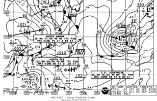
This is a list of meteorology topics. The terms relate to meteorology, the interdisciplinary scientific study of the atmosphere that focuses on weather processes and forecasting.

Extratropical cyclones, sometimes called mid-latitude cyclones or wave cyclones, are low-pressure areas which, along with the anticyclones of high-pressure areas, drive the weather over much of the Earth. Extratropical cyclones are capable of producing anything from cloudiness and mild showers to severe gales, thunderstorms, blizzards, and tornadoes. These types of cyclones are defined as large scale (synoptic) low pressure weather systems that occur in the middle latitudes of the Earth. In contrast with tropical cyclones, extratropical cyclones produce rapid changes in temperature and dew point along broad lines, called weather fronts, about the center of the cyclone.
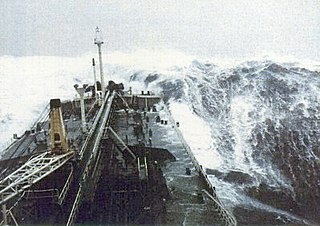
European windstorms are powerful extratropical cyclones which form as cyclonic windstorms associated with areas of low atmospheric pressure. They can occur throughout the year, but are most frequent between October and March, with peak intensity in the winter months. Deep areas of low pressure are common over the North Atlantic, and occasionally start as nor'easters off the New England coast. They frequently track across the North Atlantic Ocean towards the north of Scotland and into the Norwegian Sea, which generally minimizes the impact to inland areas; however, if the track is further south, it may cause adverse weather conditions across Central Europe, Northern Europe and especially Western Europe. The countries most commonly affected include the United Kingdom, Ireland, the Netherlands, Norway, Germany, the Faroe Islands and Iceland.
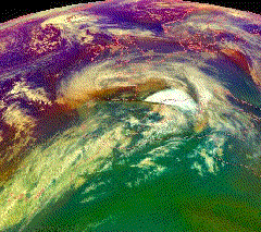
The Braer Storm was the most intense extratropical cyclone ever recorded over the northern Atlantic Ocean. Developing as a weak frontal wave on 8 January 1993, the system moved rapidly northeast. The combination of the absorption of a second low-pressure area to its southeast, a stronger than normal sea surface temperature differential along its path, and the presence of a strong jet stream aloft led to a rapid strengthening of the storm, with its central pressure falling to an estimated 914 hPa on 10 January. Its strength was well predicted by forecasters in the United Kingdom, and warnings were issued before the low initially developed.

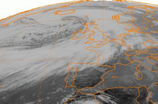
Hurricane Bawbag, also known as Cyclone Friedhelm was an intense extratropical cyclone which brought hurricane-force winds to Scotland at the beginning of December 2011. The storm also brought prolonged gales and rough seas to the rest of the British Isles, as well as parts of Scandinavia. On 8 December, winds reached up to 165 mph (266 km/h) at elevated areas, with sustained wind speeds of up to 80 mph (130 km/h) reported across populous areas. The winds uprooted trees and resulted in the closure of many roads, bridges, schools and businesses. Overall, the storm was the worst to affect Scotland in 10 years, though a stronger storm occurred less than a month afterwards, on 3 January 2012. Although the follow-up storm was more intense, the winter of 2011–12 is usually remembered for Bawbag among Scots.
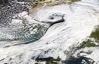
Cyclone Ulli was an intense European windstorm. Forming on December 31, 2011 off the coast of New Jersey, Ulli began a rapid strengthening phase on January 2 as it sped across the Atlantic. Ulli was the costliest disaster in January 2012 globally. The damage from the storm in Glasgow was also compared to a storm in 1968.
Marine weather forecasting is the process by which mariners and meteorological organizations attempt to forecast future weather conditions over the Earth's oceans. Mariners have had rules of thumb regarding the navigation around tropical cyclones for many years, dividing a storm into halves and sailing through the normally weaker and more navigable half of their circulation. Marine weather forecasts by various weather organizations can be traced back to the sinking of the Royal Charter in 1859 and the RMS Titanic in 1912.

2013–2014 Atlantic winter storms in Europe were a series of winter storms affecting areas of Atlantic Europe and beyond. The French Atlantic coastal regions, South West and Southern England, West Wales, Ireland, Spanish Atlantic coastal regions were especially affected by a "conveyor belt" series of high-precipitation storms and by high tides. Many storms were explosively deepened by a strong jet stream, many deepening below 950 hPa. The repeated formation of large deep lows over the Atlantic brought storm surges and large waves which coincided with some of the highest astronomical tides of the year and caused coastal damage. The low pressure areas brought heavy rainfalls which led to flooding, which became most severe over parts of England such as at the Somerset Levels. The repeated storms fit into a pattern of disturbed weather in the Northern Hemisphere, which saw from November 2013 a disturbance to the jet stream in the western Pacific, which propagated eastwards bringing a warm winter to Alaska, drought to California, and repeated cold air outbreaks to the eastern USA where the early 2014 North American cold wave resulted.
The 2015–16 UK and Ireland windstorm season was the first instance of the United Kingdom's Met Office and Ireland's Met Éireann naming extratropical cyclones. The season started on 10 November with the naming of Storm Abigail and ended on 28 March with the dissipation of Storm Katie. With a total of eleven named storms, the 2015–16 season is the most active to date.

Weather system naming in Europe follows several multinational schemes under the EUMETNET framework. On the north Atlantic coast, the United Kingdom's Met Office, in collaboration with its Irish counterpart Met Éireann and, since 2019, its Dutch counterpart the Royal Netherlands Meteorological Institute (KNMI), decided to introduce a storm naming system following the St Jude's day storm on 27–28 October 2013 which caused 17 deaths in Europe and the 2013–14 Atlantic winter storms in Europe to give a single, authoritative naming system to prevent confusion with the media and public using different names for the same storms. The first European windstorm to be named was Abigail on 10 November 2015. The definitive list is combined from suggestions from the three countries.
The 2017–2018 European windstorm season was the third instance of seasonal European windstorm naming. France, Spain and Portugal took part in winter storm naming for the first time this season.

The 2019–20 European windstorm season was the fifth instance of seasonal European windstorm naming in Europe. This is the first season in which the Netherlands participates, joining Ireland's and the United Kingdom's meteorological agencies. The new season's storm names were released on 6 September 2019. In July 2019, it was announced that storm seasons would run from 1 September 2019 to 1 September 2020. The Portuguese, Spanish and French meteorological agencies again collaborated too, joined by the Belgian meteorological agency.

The 2022–23 European windstorm season is both the deadliest and costliest European windstorm season on record. The most notable system of the season was Storm Daniel, which became the deadliest and costliest medicane ever recorded and the deadliest tropical or subtropical system worldwide since at least 2008.

