Cyclone Phethai

Last updated
Severe Cyclonic Storm Phethai
Severe cyclonic storm (IMD  scale)
Tropical cyclone (SSHWS)
Phethai 2018-12-15 0740Z.jpg
Cyclone Phethai north of Sri Lanka on December 15
FormedDecember 13, 2018
DissipatedDecember 18, 2018
(Post-tropical after December 17)
Highest winds 3-minute sustained: 100 km/h (65 mph)
1-minute sustained: 100 km/h (65 mph)
Lowest pressure992 hPa (mbar); 29.29 inHg
Fatalities8 total
Damage$100 million (2018 USD)
Areas affected Sri Lanka, East India, Northeast India
Part of the 2018 North Indian Ocean cyclone season

Severe Cyclonic Storm Phethai was a tropical cyclone which affected some portions of Sri Lanka and India during December 2018. The fourteenth depression, ninth deep depression, seventh cyclonic storm, and fifth severe cyclonic storm of the 2018 North Indian Ocean cyclone season, Phethai developed from an area of low pressure that formed over the Bay of Bengal on December 13. Having forecasted not to develop significantly, the depression then strengthened to a deep depression later that day before becoming a cyclonic storm on December 15. Phethai further intensified and peaked to a severe cyclonic storm, the following day. The system then steadily weakened due to land interaction and increasing wind shear, before making landfall as a disorganized system over Andhra Pradesh on December 17. It degenerated to an area of low-pressure inland, the next day.

Contents

Phethai caused over eight fatalities during its path towards East India. Some rice crops and paddies were destroyed and flooded, while over 31,600 individuals were evacuated to different centers in Godavari District and Odisha. The total damages from the cyclone were finalized at $100 million (2018 USD).

Meteorological history

Map plotting the track and intensity of the storm, according to the Saffir-Simpson scale

Map key
Saffir-Simpson scale
.mw-parser-output .div-col{margin-top:0.3em;column-width:30em}.mw-parser-output .div-col-small{font-size:90%}.mw-parser-output .div-col-rules{column-rule:1px solid #aaa}.mw-parser-output .div-col dl,.mw-parser-output .div-col ol,.mw-parser-output .div-col ul{margin-top:0}.mw-parser-output .div-col li,.mw-parser-output .div-col dd{page-break-inside:avoid;break-inside:avoid-column}
.mw-parser-output .legend{page-break-inside:avoid;break-inside:avoid-column}.mw-parser-output .legend-color{display:inline-block;min-width:1.25em;height:1.25em;line-height:1.25;margin:1px 0;text-align:center;border:1px solid black;background-color:transparent;color:black}.mw-parser-output .legend-text{}
Tropical depression (<=38 mph, <=62 km/h)

Tropical storm (39-73 mph, 63-118 km/h)

Category 1 (74-95 mph, 119-153 km/h)

Category 2 (96-110 mph, 154-177 km/h)

Category 3 (111-129 mph, 178-208 km/h)

Category 4 (130-156 mph, 209-251 km/h)

Category 5 (>=157 mph, >=252 km/h)

Unknown
Storm type
Tropical cyclone
Subtropical cyclone
Extratropical cyclone / Remnant low / Tropical disturbance / Monsoon depression Phethai 2018 track.png
Map plotting the track and intensity of the storm, according to the Saffir–Simpson scale
Map key
  Tropical depression (≤38 mph, ≤62 km/h)
  Tropical storm (39–73 mph, 63–118 km/h)
  Category 1 (74–95 mph, 119–153 km/h)
  Category 2 (96–110 mph, 154–177 km/h)
  Category 3 (111–129 mph, 178–208 km/h)
  Category 4 (130–156 mph, 209–251 km/h)
  Category 5 (≥157 mph, ≥252 km/h)
  Unknown
Storm type
ArrowUp.svg Extratropical cyclone / Remnant low / Tropical disturbance / Monsoon depression

At 06:00 UTC on December 7, the India Meteorological Department (IMD) began to note in their bulletins that an area of low-pressure could significantly form over the Bay of Bengal over the next 48 hours. [1] The American-based Joint Typhoon Warning Center (JTWC) also began to monitor the developing system later that day. [2] The IMD later reported that a low-pressure area had formed over the Bay of Bengal, influenced by a trough of low pressure, at 12:00 UTC on December 9. The agency noted that conditions would be favorable for the system to develop further, due to the Madden–Julian oscillation phase being at a three. Over the next couple of days, the low-pressure area produced moderate to deep convection, with the IMD designating the system as a well—marked low-pressure area on December 11. At 3:00 UTC on December 13, the IMD upgraded the low-pressure area into a tropical depression, while located roughly 530 miles (855 km) east-southeast of Trincomalee, Sri Lanka. [1] At the same time, the JTWC issued a Tropical Cyclone Formation Alert (TCFA) on the system. [2]

The depression moved north-northwestward towards the coast of India for the next few days, being steered by an anticyclone over Southeast Asia. While doing so, the depression strengthened into a deep depression according to the IMD, by 18:00 UTC on December 13, while located about 645 miles (1,040 km) south-southeast of Chennai, Tamil Nadu. Deep convection associated with the system began to increase, while global prediction models suggested further strengthening. [1] The JTWC released their first warning on the depression at 6:00 UTC on December 15. [2] Just 9 hours later, the deep depression strengthened into a cyclonic storm, and was provided the name Phethai by the IMD, while located around 480 miles (770 km) south-southeast of Machilipatnam, Andhra Pradesh. The storm changed little in appearance over the next 26 hours, before being upgraded into a severe cyclonic storm, at 17:30 UTC the next day. At this time, Phethai reached its peak intensity with 1–minute sustained winds of around 65 mph (105 km/h), and a minimum pressure of 992 mbar (29.29 inHg). The cyclone then maintained this intensity for over 12 hours before weakening due to increasing wind shear. By 6:00 UTC on December 17, the structure of the storm began to disorganize, with the center becoming ill-defined. Shortly afterwards, Phethai moved onshore in Andhra Pradesh, near the town of Yanam, just a few hours later. [1] [3]

Just an hour later, the JTWC issued their final warning on Phethai, while it was located just off the coast of Eastern India. [2] The IMD soon reported that the cyclone had weakened into a deep depression, inland over Andhra Pradesh, at 15:00 UTC that same day. The depression remained disorganized as it moved across Eastern India, making a second landfall in the country near Tuni. Phethai continued to weaken inland, being downgraded into a depression by 19:30 UTC that day. The IMD issued their final bulletin on the depression at 3:00 UTC the following day, as it degenerated into an area of low pressure over the northwestern Bay of Bengal, while producing minimal convection. [1] Although, dissipation was later corrected to 0:00 UTC. [3]

Preparations

Cyclone Phethai affected areas still recovering from the impacts of cyclones Daye, Titli, and Gaja. [4] Ahead of the storm, boats were prohibited from leaving port with fishing activities halted. [5]

Cyclone Phethai making landfall near Yanam on December 17 Cyclone Phethai during its landfall near Kakinada.png
Cyclone Phethai making landfall near Yanam on December 17

Roughly 10 shelters were opened within Andhra Pradesh. Over 2,000 electrical workers were assembled to help restore power in Phethai's aftermath. Police and firefighters formed special crews to help with debris removal from streets. Firefighters also prepared boats and lifejackets, with the National Disaster Response Force and State Disaster Response Force assembling seven rescue teams. Marketing departments arranged vegetables and necessities to provide to people staying at shelters. The Indian Coast Guard kept ships and aircraft along the country's east coast to help with aid efforts following the cyclone. [5]

Over 10,000 people prepared for disaster response as the storm neared. Numerous flights heading to Visakhapatnam were cancelled, with trains being halted. [6] N. Chandrababu Naidu, the chief minister of Andhra Pradesh, hosted a teleconference with the collector's of four districts in the state, where cyclone preparations were planned and discussed. Paddy crops were attempted to be saved by farmers in the Krishna and Godavari river deltas. [7] Roughly 20,000 people were evacuated ahead of the cyclone in the nearby Godavari District. [8] Within Krishna district, 68 relief centers, 15 health teams, and 155 firefighters were put on standby, as local officials prepared for the storm. The Rural Water Supply setup 3 water tankers in each of the district's villages, while also producing more than 500 sandbags. Machinery was also readied to help clear downed trees. While electrical departments ordered crews to be stationed every 6 miles (10 km), to quickly restore power. [9] [10]

In Odisha, roughly 11,600 residents were evacuated from the Gajapati district. These residents were evacuated due to the damage remaining from Cyclone Titli, just two months previously. [11] Farmers in the state were asked to take measures to protect their crops from the results of heavy rainfall. [12] The India Meteorological Department (IMD) warned of a chance of heavy rains in the northern part of Tamil Nadu. [13]

Some fishing communities were advised to exercise cautions when fishing from Trincomalee to Mannar via Kankesanthurai in Sri Lanka. [14] Gusty winds and some squally rainfall were also expected in these areas. [14]

Impact

Conditions before and after the passage of Phethai in Visakhapatnam.
Weather just before Phethai cyclone stuck in Visakhapatnam.jpg
Weather after Phethai cyclone stuck in Visakhapatnam.jpg

Showers and thunderstorms associated with Phethai affected Sri Lanka during its development. [15] After moving onshore, Phethai brought torrential rainfall and strong winds in Andhra Pradesh which downed trees and electrical lines. [16] A peak precipitation accumulation of 156.5 mm (6.16 in) was reported in the city of Ninnimamidivalasa in Visakhapatnam, [17] while the village of Pachipenta recorded a rainfall amount of 136 mm. [18] During the storm, seven fishermen went missing offshore the city. [19]

A 40-year-old man was killed after a boulder crashed through his roof in Vijayawada. Another man in the city was hurtled down a small hill due to heavy rainfall, killing him. A 68-year-old woman was also killed in Pallepalem. In the East Godavari district, streets in more than 50 locations were left impassible but were quickly cleared. Power outages were reported in 99 villages within the district. [17] [20]

In the town of Amalapuram, a rare phenomenon of fish rain was reported along a canal on December 17. A video of the incident went viral on social media, showing more than 100 bodies of fish on land near the canal. A possible cause of this occurrence was high wind bringing the bodies of fish and frogs onshore. [21]

Aftermath

Following the cyclone, the Government of Odisha began to assess damage to crops in the state. [22] Some assistance would be given to the farmers regarding the major damages to rice paddies from the aftermath of the cyclone.[ citation needed ]

See also

Related Research Articles

2005 North Indian Ocean cyclone season Cyclone season in the North Indian ocean

The 2005 North Indian Ocean cyclone season was destructive and deadly to southern India, despite the weak storms. The basin covers the Indian Ocean north of the equator as well as inland areas, sub-divided by the Arabian Sea and the Bay of Bengal. Although the season began early with two systems in January, the bulk of activity was confined from September to December. The official India Meteorological Department tracked 12 depressions in the basin, and the unofficial Joint Typhoon Warning Center (JTWC) monitored two additional storms. Three systems intensified into a cyclonic storm, which have sustained winds of at least 63 km/h (39 mph), at which point the IMD named them.

2006 North Indian Ocean cyclone season North Indian Ocean tropical cyclone season

The 2006 North Indian Ocean cyclone season had no bounds, but cyclones tend to form between April and December, with peaks in May and November. These dates conventionally delimit the period of each year when most tropical cyclones form in the northern Indian Ocean.

2000 North Indian Ocean cyclone season Cyclone season in the North Indian ocean

The 2000 North Indian Ocean cyclone season was fairly quiet compared to its predecessor, with all of the activity originating in the Bay of Bengal. The basin comprises the Indian Ocean north of the equator, with warnings issued by the India Meteorological Department (IMD) in New Delhi. There were six depressions throughout the year, of which five intensified into cyclonic storms – tropical cyclones with winds of 65 mph (105 km/h) sustained over 3 minutes. Two of the storms strengthened into a Very Severe Cyclonic Storm, which has winds of at least 120 km/h (75 mph), equivalent to a minimal hurricane. The Joint Typhoon Warning Center (JTWC) also tracked storms in the basin on an unofficial basis, estimating winds sustained over 1 minute.

1996 North Indian Ocean cyclone season Cyclone season in the North Indian Ocean in 1996

The 1996 North Indian Ocean cyclone season featured several deadly tropical cyclones, with over 2,000 people killed during the year. The India Meteorological Department (IMD) – the Regional Specialized Meteorological Center for the northern Indian Ocean as recognized by the World Meteorological Organization – issued warnings for nine tropical cyclones in the region. Storms were also tracked on an unofficial basis by the American-based Joint Typhoon Warning Center, which observed one additional storm. The basin is split between the Bay of Bengal off the east coast of India and the Arabian Sea off the west coast. During the year, the activity was affected by the monsoon season, with most storms forming in June or after October.

1990 North Indian Ocean cyclone season

The 1990 North Indian Ocean cyclone season featured a below average total of twelve cyclonic disturbances and one of the most intense tropical cyclones in the basin on record. During the season the systems were primarily monitored by the India Meteorological Department, while other warning centres such as the United States Joint Typhoon Warning Center also monitored the area. During the season, there were at least 1,577 deaths, while the systems caused over US$693 million in damages. The most significant system was the 1990 Andhra Pradesh cyclone, which was the most intense, damaging, and the deadliest system of the season.

Timeline of the 2008 North Indian Ocean cyclone season

The 2008 North Indian Ocean cyclone season officially ran throughout the year during 2008, with the first depression forming on April 27. The timeline includes information that was not operationally released, meaning that information from post-storm reviews by the Joint Typhoon Warning Center (JTWC), and the India Meteorological Department (IMD), such as information on a storm that was not operationally warned on. This timeline documents all the storm formations, strengthening, weakening, landfalls, extratropical transitions, as well as dissipation's during the 2008 North Indian Ocean cyclone season.

1994 North Indian Ocean cyclone season

The 1994 North Indian Ocean cyclone season was a below-average year in which eight tropical cyclones affected seven countries bordering the North Indian Ocean. The India Meteorological Department tracks all tropical cyclones in the basin, north of the equator. The first system developed on March 21 in the Bay of Bengal, the first March storm in the basin since 1938. The second storm was the most powerful cyclone of the season, attaining maximum sustained winds of 215 km/h (135 mph) in the northern Bay of Bengal. Making landfall near the border of Bangladesh and Myanmar, the cyclone killed 350 people and left US$125 million in damage.

2013 North Indian Ocean cyclone season North Indian Ocean tropical cyclone season

The 2013 North Indian Ocean cyclone season was an event in the annual cycle of tropical cyclone formation, in which tropical cyclones formed in the North Indian Ocean and Arabian Sea. The season had no official bounds, but cyclones typically formed between May and December, with the peak from October to November. These dates conventionally delimit the period of each year when most tropical cyclones form in the northern Indian Ocean.

2014 North Indian Ocean cyclone season North Indian Ocean tropical cyclone season

The 2014 North Indian Ocean cyclone season was an event in the annual cycle of tropical cyclone formation. The season included two very severe cyclonic storms, both in October, and one other named cyclonic storm, classified according to the tropical cyclone intensity scale of the India Meteorological Department. Cyclone Hudhud is estimated to have caused US$3.58 billion in damage across eastern India, and more than 120 deaths.

Cyclone Helen (2013)

Severe Cyclonic Storm Helen was a relatively weak tropical cyclone that formed in the Bay of Bengal Region on 18 November 2013, from the remnants of Tropical Storm Podul. It was classified as Deep Depression BOB 06 by the IMD on 19 November. As it was moving on a very slow northwest direction on 20 November, it became Cyclonic Storm Helen as it brought light to heavy rainfall in eastern India. It then became a Severe Cyclonic Storm on the afternoon hours of 21 November.

Cyclone Lehar North Indian cyclone in 2013

Very Severe Cyclonic Storm Lehar was a tropical cyclone that primarily affected the Andaman and Nicobar Islands and the Indian state of Andhra Pradesh. Lehar was the second most intense tropical cyclone of the 2013 season, surpassed by Cyclone Phailin, as well as one of the two relatively strong cyclones that affected Southern India in November 2013, the other being Cyclone Helen.

Cyclone Hudhud

Extremely Severe Cyclonic Storm Hudhud was a strong tropical cyclone that caused extensive damage and loss of life in eastern India and Nepal during October 2014. Hudhud originated from a low-pressure system that formed under the influence of an upper-air cyclonic circulation in the Andaman Sea on October 6. Hudhud intensified into a cyclonic storm on October 8 and as a Severe Cyclonic Storm on October 9. Hudhud underwent rapid deepening in the following days and was classified as a Very Severe Cyclonic Storm by the IMD. Shortly before landfall near Visakhapatnam, Andhra Pradesh, on October 12, Hudhud reached its peak strength with three-minute wind speeds of 185 km/h (115 mph) and a minimum central pressure of 960 mbar (28.35 inHg). The system then drifted northwards towards Uttar Pradesh and Nepal, causing widespread rains in both areas and heavy snowfall in the latter.

2016 North Indian Ocean cyclone season North Indian Ocean tropical cyclone season

The 2016 North Indian Ocean cyclone season was an event in the annual cycle of tropical cyclone formation. It was the deadliest season since 2010, killing more than 400 people. The season was an average one, seeing four named storms, with one further intensifying into a very severe cyclonic storm. The first named storm, Roanu, developed on 19 May while the season's last named storm, Vardah, dissipated on 18 December. The North Indian Ocean cyclone season has no official bounds, but cyclones tend to form between April and December, with the two peaks in May and November. These dates conventionally delimit the period of each year when most tropical cyclones form in the northern Indian Ocean.

2018 North Indian Ocean cyclone season North Indian Ocean tropical cyclone season

The 2018 North Indian Ocean cyclone season was one of the most active North Indian Ocean cyclone seasons since 1992, with the formation of fourteen depressions and seven cyclones. The North Indian Ocean cyclone season has no official bounds, but cyclones tend to form between April and December, with the two peaks in May and November. These dates conventionally delimit the period of each year when most tropical cyclones form in the northern Indian Ocean.

2019 North Indian Ocean cyclone season North Indian Ocean tropical cyclone season

The 2019 North Indian Ocean cyclone season was the most active North Indian Ocean cyclone season on record, in terms of cyclonic storms, however the 1992 season was more active according to the Joint Typhoon Warning Center. The season featured 12 depressions, 11 deep depressions, 8 cyclonic storms, 6 severe cyclonic storms, 6 very severe cyclonic storms, 3 extremely severe cyclonic storms, and 1 super cyclonic storm, Kyarr, the first since Cyclone Gonu in 2007. Additionally, it was also the third-costliest season recorded in the North Indian Ocean, only behind the 2020 and 2008 seasons.

2020 North Indian Ocean cyclone season North Indian Ocean tropical cyclone season

The 2020 North Indian Ocean cyclone season was the costliest North Indian Ocean cyclone season on record, mostly due to Cyclone Amphan. The North Indian Ocean cyclone season has no official bounds, but cyclones tend to form between April and November, with peaks in late April to May and October to November. These dates conventionally delimit the period of each year when most tropical cyclones form in the northern Indian Ocean. The season began on May 16 with the designation of Depression BOB 01 in the Bay of Bengal, which later became Amphan. Cyclone Amphan was the strongest storm in the Bay of Bengal in 21 years and would break Nargis of 2008's record as the costliest storm in the North Indian Ocean. The season concluded with the dissipation of Cyclone Burevi on December 5. Overall, the season was slightly above average, seeing the development of five cyclonic storms.

2021 North Indian Ocean cyclone season North Indian Ocean tropical cyclone season

The 2021 North Indian Ocean cyclone season is an ongoing event in the annual cycle of tropical cyclone formation. The North Indian Ocean cyclone season has no official bounds, but cyclones tend to form between April and December, peaking between May to November. These dates conventionally delimit the period of each year when most tropical cyclones form in the northern Indian Ocean.

Cyclone Titli Deadly tropical cyclone that impacted the East coast of India

Very Severe Cyclonic Storm Titli was a deadly and destructive tropical cyclone that caused extensive damage to Eastern India and Bangladesh in 2018. The fifth named storm to form in the 2018 North Indian Ocean cyclone season, the storm developed from a low-pressure area that formed in the Andaman Sea on October 6. Over the next two days, the low-pressure area entered the Bay of Bengal and became a depression on October 8, receiving the designation BOB 08 from the IMD. Afterward, the storm rapidly strengthened, becoming a Very Severe Cyclonic Storm on October 9, equivalent to a Category 3 hurricane on the Saffir–Simpson scale (SSHWS). On October 11, Titli made landfall in eastern India at peak intensity, before weakening into a remnant low on the next day.

Timeline of the 2013 North Indian Ocean cyclone season Timeline of an average North Indian Ocean cyclone season

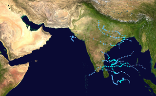
The 2013 North Indian Ocean cyclone season was an average season during the period of tropical cyclone formation in the North Indian Ocean. The season began in May with the formation of Cyclone Viyaru, which made landfall on Bangladesh, destroying more than 26,500 houses. After a period of inactivity, Cyclone Phailin formed in October, and became an extremely severe cyclonic storm. Additionally, it was a Category 5-equivalent cyclone on the Saffir–Simpson hurricane wind scale. It then made landfall in the Indian states of Andhra Pradesh and Odisha, becoming the most intense cyclone to strike the country since the 1999 Odisha cyclone. In November, cyclones Helen and Lehar formed, and they both made landfall in Andhra Pradesh just one week away from each other. The latter also affected the Andaman and Nicobar Islands.

Cyclones Gulab and Shaheen North Indian Ocean cyclones in 2021

Cyclones Gulab and Shaheen were two related, consecutive tropical cyclones that caused considerable damage to South and West Asia. Gulab impacted eastern India, while Shaheen impacted Pakistan, Iran, Oman and the United Arab Emirates. Gulab was the third named storm of the 2021 North Indian Ocean cyclone season, as well as the fourth named storm of the season after its reformation in the Arabian Sea as Shaheen. The cyclone's origins can be traced back to a low-pressure area situated over the Bay of Bengal on September 24. The system quickly organized, with the India Meteorological Department (IMD) upgrading the system to a depression on the same day. On the next day, the system strengthened into a Cyclonic Storm, and the IMD assigned it the name Gulab. On September 26, Gulab made landfall in India's Andhra Pradesh but weakened overland, before degenerating into a remnant low on September 28. The system continued moving westward, emerging into the Arabian Sea on September 29, before regenerating into a depression early on September 30. Early on October 1, the system restrengthened into a Cyclonic Storm, which the IMD named Shaheen. The system gradually strengthened as it entered the Gulf of Oman. While slowly moving westward, the storm turned southwestward, subsequently making an extremely rare landfall in Oman on October 3, as a Category 1-equivalent cyclone. Shaheen then rapidly weakened, before dissipating the next day.

References

  1. 1 2 3 4 5 "Cyclone Phethai Archive Bulletin" (PDF). India Meteorological Department. Retrieved April 4, 2021.
  2. 1 2 3 4 "Annual Tropical Cyclone Report 2018" (PDF). Joint Typhoon Warning Center. Retrieved April 4, 2021.
  3. 1 2 "2019 Best Track Archive". India Meteorological Department. Retrieved February 3, 2021.
  4. "After Gaja, Andhra Pradesh now braces for Cyclone Phethai". Mint. December 15, 2018. Retrieved February 6, 2021.
  5. 1 2 "Krishna braces for Phethai". The Hindu. December 15, 2018. Retrieved February 2, 2021.
  6. "Cyclone Phethai in India". Disasters Charter. December 17, 2018. Retrieved February 2, 2021.
  7. TNN (December 16, 2018). "Cyclone Phethai to Hit Kakinada, AP, Today Afternoon; 350 Villages on High Alert". The Weather Channel India. Retrieved February 2, 2021.
  8. "Cyclone Phethai Highlights: 20,000 people shifted to relief camps, storm weakens". The Indian Express. December 18, 2018. Retrieved February 3, 2021.
  9. "Cyclone Phethai to hit Andhra Pradesh on December 17; state on high alert". MyNation. December 15, 2018. Retrieved February 4, 2021.
  10. VKL Gayatri (December 16, 2018). "Cyclone Phethai: Andhra Pradesh govt. gears up all its wings to attend emergencies". The Hans India. Retrieved February 4, 2021.
  11. Press Trust of India (December 18, 2018). "Over 11,000 Evacuated In Odisha As Cyclone Phethai Hits Andhra". NDTV. Retrieved February 2, 2021.
  12. "Odisha government evacuates 11,600 people as Cyclone Phethai makes landfall in neighbouring Andhra Pradesh". India TV News. December 18, 2018. Retrieved February 4, 2021.
  13. "Cyclone Phethai: IMD predicts heavy rain in coastal parts of Andhra Pradesh, Tamil Nadu on weekend". Scroll.in. December 13, 2018. Retrieved March 7, 2021.
  14. 1 2 "Cyclonic storm 'Phethai' moving away from Sri Lanka". www.news.lk-gb. Retrieved 2021-04-07.
  15. "As Phethai cyclone intensifies: Fishermen warned". Daily Mirror. December 16, 2018. Retrieved February 3, 2021.
  16. "Deadly Cyclone Phethai makes landfall in India". Al Jazeera. December 18, 2018. Retrieved February 5, 2021.
  17. 1 2 Charan Teja (December 18, 2018). "Cyclone Phethai claims two lives in Andhra, weakens after making landfall". The News Mir. Retrieved March 7, 2021.
  18. "Deadly Cyclone Phethai makes landfall in India". www.aljazeera.com. Retrieved 2021-04-07.
  19. Press Trust of India (December 18, 2018). "Cyclone Phethai leaves one dead, seven missing in Andhra Pradesh; 'weakened' storm now moving towards Odisha". Firstpost. Retrieved March 7, 2021.
  20. PTI (December 18, 2018). "One Killed as Cyclone Phethai Storms Through Andhra Pradesh". The Wire. Retrieved March 7, 2021.
  21. V Kamalakara Rao (December 17, 2018). "Cyclone Phethai Showers Fish on Andhra's Amalapuram". The Weather Channel India. Retrieved March 7, 2021.
  22. Press Trust of India (December 19, 2018). "Odisha to assess crop damage caused by Cyclone Phethai". Business Standard. Retrieved March 7, 2021.