Cyclone Titli

Last updated
Map key
  Tropical depression (≤38 mph, ≤62 km/h)
  Tropical storm (39–73 mph, 63–118 km/h)
  Category 1 (74–95 mph, 119–153 km/h)
  Category 2 (96–110 mph, 154–177 km/h)
  Category 3 (111–129 mph, 178–208 km/h)
  Category 4 (130–156 mph, 209–251 km/h)
  Category 5 (≥157 mph, ≥252 km/h)
  Unknown
Storm type
Disc Plain black.svg Tropical cyclone
Solid black.svg Subtropical cyclone
ArrowUp.svg Extratropical cyclone, remnant low, tropical disturbance, or monsoon depression

As early as October 3, the India Meteorological Department (IMD) anticipated the development of a tropical cyclone in the Bay of Bengal. Environmental conditions for development included warm sea surface temperatures up to 31 °C (88 °F) and low wind shear. Early on October 7, a low pressure area developed in the Andaman Sea, accompanied by intense convection, or thunderstorms. [1] A weak anticyclone was located over an elongated low-level circulation associated with the system. With tropical cyclone forecast models uncertain about the system's future, the American-based Joint Typhoon Warning Center (JTWC) assessed a low chance for development on October 7. [2] On October 8, the system organized into a depression in the central Bay of Bengal, supported by a moist environment. [1]

The circulation gradually became better organized, developing outflow in its periphery. [3] The depression moved generally northwestward toward the southeast coast of India, steered by a ridge to its northeast. With favorable conditions, the depression gradually strengthened, first to a deep depression late on October 8, and further into a cyclonic storm early the next day; at that time, the IMD named the storm Titli. [1] Also on October 9, the JTWC initiated warnings on the system, classifying it as Tropical Cyclone 06B. [4] As it approached the coast of India, Titli underwent rapid deepening as its structure evolved into a mature cyclone. The storm intensified into a severe cyclonic storm late on October 9. Early the next day, Titli strengthened further into a very severe cyclonic storm, as an eye formed in the center of the thunderstorms. At the same time, Very Intense Cyclonic Storm Luban was located in the Arabian Sea, marking the first time since 1977 where there were two simultaneous very severe cyclonic storms in the North Indian Ocean. Titli continued strengthening, with estimated peak winds of 150 km/h (95 mph) according to the IMD. [1] Meanwhile, the JTWC assessed that the cyclone reached peak winds of 195 km/h (120 mph), the equivalent of a Category 3 on the Saffir–Simpson scale. [5]

Late on October 10, Titli made landfall near Palasa, Andhra Pradesh, at peak intensity, as its eye contracted to a diameter of 12 km (7.5 mi). [1] The storm quickly weakened over land as it turned to the northeast through Odisha state, encountering cooler, drier air as it moved around the western end of the ridge. [1] [6] By late on October 11, Titli fell back to depression status. It moved into West Bengal and weakened into a well-marked low on October 12, spreading into neighboring Bangladesh. [1]

Preparations, impacts, and aftermath

Very Severe Cyclonic Storms Luban (left) and Titli (right) over the Arabian Sea and the Bay of Bengal, respectively, on 10 October 2018 as two simultaneous cyclones Luban and Titli 2018-10-10 0745Z-0926Z.jpg
Very Severe Cyclonic Storms Luban (left) and Titli (right) over the Arabian Sea and the Bay of Bengal, respectively, on 10 October 2018 as two simultaneous cyclones

Ahead of Titli's landfall, officials in India and Bangladesh warned for fishermen to avoid sailing through Titli in the Bay of Bengal and to seek shelter. [7] [8] The IMD issued various bulletins and warnings for the public via social media, WhatsApp, and other briefings to the press. [1] Officials advised people in coastal areas to evacuate, [9] and ultimately about 300,000 people left their houses, using about 2,000 shelters and relief camps. [10] 123 pregnant women were transported to hospitals as a precaution. [11] Schools and child-care centers were closed in parts of Odisha. [12] The Bangladesh Inland Water Transport Authority suspended river transport vessels during the passage of the storm. [13]

While moving through southeastern India, Titli dropped heavy rainfall. Mohana, Odisha recorded 460 mm (18 in) of rainfall over 48 hours. Tekkali in northeastern Andhra Pradesh recorded 330 mm (13 in) of precipitation over the same time period. Heavy rainfall also occurred in West Bengal and across northeast India. In addition to floods from rainfall, Titli produced a storm surge as it moved ashore. Palasa in Andhra Pradesh recorded a water rise of about 1 m (3.3 ft). The cyclone also produced strong winds near its landfall point, with gusts estimated as high as 165 km/h (105 mph). [1] Korlam in extreme northeastern Andhra Pradesh recorded wind gusts of 126 km/h (78 mph). [14]

Across southeastern India, Titli killed 85 people, with eight of the deaths in Andhra Pradesh, and the other 77 in Odisha. [1] In Gajapati district in Odisha, a single landslide killed 12 people, after residents sought refuge in a cave. [15] Other deaths occurred due to floods, housing damage, and falling trees. [16] [14] Damage from flooding caused by Titli totaled at 3,673.1 crore (US$507 million) in Andhra Pradesh, [17] and ₹3,000 crore (US$413 million) in Odisha. [18] Along its path, Titli damaged 127,081 houses, forcing 63,562 people to stay in relief camps. [19] Floodwaters entered the jail in Asika. [19] Two major rivers, the Rushikulya and the Vamsadhara, swelled to reach dangerous levels, causing flooding in three districts that affected more than 600,000 people. [20] The cyclone uprooted many trees along its path, [1] blocking roads and knocking down power lines. [1] [14] Authorities estimated that 6,000 to 7,000 electrical poles were uprooted by Titli's strong winds. As a result, 400,000 to 500,000 people were without power in Andhra Pradesh. [21] In Srikakulam, residents faced water shortages when the storm polluted wells and water systems. At least five bridges were damaged across the area. [19] Floods damaged more than 3,785 km2 (1,461 sq mi) of crops, [22] and killed many farm animals, including more than 40,000 birds. [19] Titli caused major destruction to the East Coast railway, forcing the cancellation of at least six trains. [23] In Visakhapatnam along the coast, the winds damaged six boats. Three people were lost when their boat went missing from Vizianagaram. [14]

To help residents affected by the storm, the Odisha government provided financial compensation to families for 15 days, with a family of four receiving more than ₹3,000 (US$22). [20] After the storm, 15 teams from the National Disaster Response Force, along with the Odisha Disaster Rapid Action Force, were placed around Odisha. [24] Firefighters and other crews removed trees from roads. Officials provided meals and plastic sheeting for people affected by storm damage. [11] Helicopters dropped meals to people in difficult to reach areas. [15] Caritas India, a Catholic relief organization, provided families with sheeting and cleaning, including mosquito nets, blankets, and tarpaulins. [22]

In Andhra Pradesh, N. Chandrababu Naidu announced a series of relief measures to provide relief to people in Srikakulam District. After having undertaken visits to Mandals such as Vajrapukotturu and Palasa he ensured the supply of 50 kg worth rice to those belonging to the Fishermen community and 25 kg to those belonging to other communities. The government would also ensure the supply of other necessary goods such as potatoes, pulses and onions. Moreover, a compensation of Rs.1 lakh was given to the next to kin of the 7 people who lost their lives, along with other compensatory measures such as Rs. 1000 to those whose houses and shops were damaged, Rs. 5000 compensation for loss of cattle and compensation to farmers for damage to crops on basis of a survey. He also prioritized the immediate restoration of drinking water and power, clearing of roads by removing uprooted trees and undertaking repair work of railway stations and railway quarters. [25]

Cyclone Titli's effects extended into Bangladesh, where Cox's Bazar recorded three days of heavy rainfall. [26] There, the storm damaged at least 15 buildings, including some facilities for Rohingya refugee camps. [27] Landslides in Chittagong killed four people after wrecking two houses. [28]

See also

Related Research Articles

<span class="mw-page-title-main">2006 North Indian Ocean cyclone season</span>

The 2006 North Indian Ocean cyclone season had no bounds, but cyclones tend to form between April and December, with peaks in May and November. These dates conventionally delimit the period of each year when most tropical cyclones form in the northern Indian Ocean.

<span class="mw-page-title-main">2008 North Indian Ocean cyclone season</span>

The 2008 North Indian cyclone season was one of the most disastrous tropical cyclone seasons in modern history, causing more than 140,000 fatalities and over US$15 billion in damage. At the time, it was the costliest season in the North Indian Ocean, until it was surpassed by 2020. The season has no official bounds but cyclones tend to form between April and December. These dates conventionally delimit the period of each year when most tropical cyclones form in the northern Indian Ocean. There are two main seas in the North Indian Ocean—the Bay of Bengal, which is east of India, and the Arabian Sea, which is west of India. The official Regional Specialized Meteorological Centre in this basin is the India Meteorological Department (IMD), however the Joint Typhoon Warning Center releases unofficial advisories for military interests. An average of four to six storms form in the North Indian Ocean every season. Cyclones occurring between the meridians 45°E and 100°E are included in the season by the IMD.

<span class="mw-page-title-main">2000 North Indian Ocean cyclone season</span>

The 2000 North Indian Ocean cyclone season was fairly quiet compared to the year before, 1999 North Indian Ocean cyclone season, with all of the activity originating in the Bay of Bengal. The basin comprises the Indian Ocean north of the equator, with warnings issued by the India Meteorological Department (IMD) in New Delhi. There were six depressions throughout the year, of which five intensified into cyclonic storms – tropical cyclones with winds of 65 mph (105 km/h) sustained over 3 minutes. Two of the storms strengthened into a Very Severe Cyclonic Storm, which has winds of at least 120 km/h (75 mph), equivalent to a minimal hurricane. The Joint Typhoon Warning Center (JTWC) also tracked storms in the basin on an unofficial basis, estimating winds sustained over 1 minute.

<span class="mw-page-title-main">1995 North Indian Ocean cyclone season</span>

The 1995 North Indian Ocean cyclone season was below-average and was primarily confined to the autumn months, with the exception of three short-lived deep depressions in May. There were eight depressions in the basin, which is Indian Ocean north of the equator. The basin is subdivided between the Bay of Bengal and the Arabian Sea on the east and west coasts of India, respectively. Storms were tracked by the India Meteorological Department (IMD), which is the basin's Regional Specialized Meteorological Center, as well as the American-based Joint Typhoon Warning Center (JTWC) on an unofficial basis.

<span class="mw-page-title-main">1990 North Indian Ocean cyclone season</span>

The 1990 North Indian Ocean cyclone season featured a below average total of twelve cyclonic disturbances and one of the most intense tropical cyclones in the basin on record. During the season the systems were primarily monitored by the India Meteorological Department, while other warning centres such as the United States Joint Typhoon Warning Center also monitored the area. During the season, there were at least 1,577 deaths, while the systems caused over US$693 million in damages. The most significant system was the 1990 Andhra Pradesh cyclone, which was the most intense, damaging, and the deadliest system of the season.

<span class="mw-page-title-main">1991 North Indian Ocean cyclone season</span>

The 1991 North Indian Ocean Cyclone season was an extremely deadly and destructive season causing the deaths of more than 138,000 people and over $1.5 billion in damages. It was the period in which tropical cyclones formed to the north of the equator in the Indian Ocean. During the season tropical cyclones were monitored by the India Meteorological Department (IMD) and the Joint Typhoon Warning Center. The IMD assigned all depressions that it monitored with BOB followed by a number in numerical order. The JTWC also assigned a number and either the letter A or B depending on where the depression was when the first advisory was issued.

<span class="mw-page-title-main">1994 North Indian Ocean cyclone season</span>

The 1994 North Indian Ocean cyclone season was a below-average year in which eight tropical cyclones affected seven countries bordering the North Indian Ocean. The India Meteorological Department tracks all tropical cyclones in the basin, north of the equator. The first system developed on March 21 in the Bay of Bengal, the first March storm in the basin since 1938. The second storm was the most powerful cyclone of the season, attaining maximum sustained winds of 215 km/h (135 mph) in the northern Bay of Bengal. Making landfall near the border of Bangladesh and Myanmar, the cyclone killed 350 people and left US$125 million in damage.

<span class="mw-page-title-main">Tropical cyclones in India</span>

India is a country in the north of Indian Ocean that is the most vulnerable to getting hit by tropical cyclones in the basin, from the east or from the west. On average, 2–3 tropical cyclones make landfall in India each year, with about one being a severe tropical cyclone or greater.

<span class="mw-page-title-main">2013 North Indian Ocean cyclone season</span>

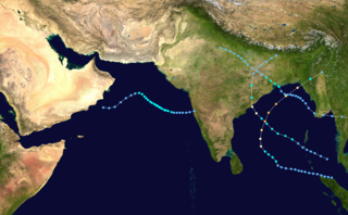
The 2013 North Indian Ocean cyclone season was an event in the annual cycle of tropical cyclone formation, in which tropical cyclones formed in the North Indian Ocean and Arabian Sea. The season had no official bounds, but cyclones typically formed between May and December, with the peak from October to November. These dates conventionally delimit the period of each year when most tropical cyclones form in the northern Indian Ocean.

<span class="mw-page-title-main">2014 North Indian Ocean cyclone season</span>

The 2014 North Indian Ocean cyclone season was an event in the annual cycle of tropical cyclone formation. The season included two very severe cyclonic storms, both in October, and one other named cyclonic storm, classified according to the tropical cyclone intensity scale of the India Meteorological Department. Cyclone Hudhud is estimated to have caused US$3.58 billion in damage across eastern India, and more than 120 deaths.

<span class="mw-page-title-main">Cyclone Lehar</span> North Indian cyclone in 2013

Very Severe Cyclonic Storm Lehar was a tropical cyclone that primarily affected the Andaman and Nicobar Islands and the Indian state of Andhra Pradesh. Lehar was the second most intense tropical cyclone of the 2013 season, surpassed by Cyclone Phailin, as well as one of the two relatively strong cyclones that affected Southern India in November 2013, the other being Cyclone Helen.

<span class="mw-page-title-main">Cyclone Hudhud</span> North Indian Ocean cyclone in 2014

Extremely Severe Cyclonic Storm Hudhud was a strong tropical cyclone that caused extensive damage and loss of life in eastern India and Nepal during October 2014. Hudhud originated from a low-pressure system that formed under the influence of an upper-air cyclonic circulation in the Andaman Sea on October 6. Hudhud intensified into a cyclonic storm on October 8 and as a Severe Cyclonic Storm on October 9. Hudhud underwent rapid deepening in the following days and was classified as a Very Severe Cyclonic Storm by the IMD. Shortly before landfall near Visakhapatnam, Andhra Pradesh, on October 12, Hudhud reached its peak strength with three-minute wind speeds of 185 km/h (115 mph) and a minimum central pressure of 960 mbar (28.35 inHg). The system then drifted northwards towards Uttar Pradesh and Nepal, causing widespread rains in both areas and heavy snowfall in the latter.

<span class="mw-page-title-main">2016 North Indian Ocean cyclone season</span>

The 2016 North Indian Ocean cyclone season was an event in the annual cycle of tropical cyclone formation. It was the deadliest season since 2010, killing more than 400 people. The season was an average one, seeing four named storms, with one further intensifying into a very severe cyclonic storm. The first named storm, Roanu, developed on 19 May while the season's last named storm, Vardah, dissipated on 18 December. The North Indian Ocean cyclone season has no official bounds, but cyclones tend to form between April and December, with the two peaks in May and November. These dates conventionally delimit the period of each year when most tropical cyclones form in the northern Indian Ocean.

<span class="mw-page-title-main">2018 North Indian Ocean cyclone season</span>

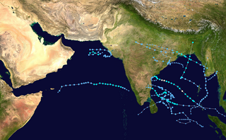
The 2018 North Indian Ocean cyclone season was one of the most active North Indian Ocean cyclone seasons since 1992, with the formation of fourteen depressions and seven cyclones. The North Indian Ocean cyclone season has no official bounds, but cyclones tend to form between April and December, with the two peaks in May and November. These dates conventionally delimit the period of each year when most tropical cyclones form in the northern Indian Ocean.

<span class="mw-page-title-main">2020 North Indian Ocean cyclone season</span>

The 2020 North Indian Ocean cyclone season was the costliest North Indian Ocean cyclone season on record, mostly due to the devastating Cyclone Amphan. The North Indian Ocean cyclone season has no official bounds, but cyclones tend to form between April and November, with peaks in late April to May and October to November. These dates conventionally delimit the period of each year when most tropical cyclones form in the northern Indian Ocean. The season began on May 16 with the designation of Depression BOB 01 in the Bay of Bengal, which later became Amphan. Cyclone Amphan was the strongest storm in the Bay of Bengal in 21 years and would break Nargis of 2008's record as the costliest storm in the North Indian Ocean. The season concluded with the dissipation of Cyclone Burevi on December 5. Overall, the season was slightly above average, seeing the development of five cyclonic storms.

<span class="mw-page-title-main">Cyclone Maarutha</span>

Cyclonic Storm Maarutha was the first tropical cyclone to make landfall in Myanmar in April. The first tropical cyclone and named storm of the 2017 North Indian Ocean cyclone season, Maarutha was a relatively short-lived and weak system, nonetheless causing notable damage in Myanmar. Maarutha formed from an area of low pressure over the southern Bay of Bengal on April 15. The next morning, RSMC New Delhi upgraded the low-pressure area to a Depression and designated it as BOB 01.

<span class="mw-page-title-main">2021 North Indian Ocean cyclone season</span>

The 2021 North Indian Ocean cyclone season was an average season, the North Indian Ocean cyclone season has no official bounds, but cyclones tend to form between April and December, peaking between May and November. These dates conventionally delimit the period of each year when most tropical cyclones form in the northern Indian Ocean. The season began on April 2, when a depression designated as BOB 01 was formed in the north Andaman Sea and quickly made landfall in Myanmar. The basin remained quiet for over a month before Cyclone Tauktae formed. It rapidly intensified into an extremely severe cyclonic storm before making landfall in Gujarat, become the strongest storm ever to strike that state since the 1998 Gujarat cyclone. Later that month, BOB 02 formed and later strengthened into Cyclone Yaas. Yaas rapidly intensified into a very severe cyclonic storm before making landfall in northwestern Odisha. The season's strongest tropical cyclone was Cyclone Tauktae, with maximum wind speeds of 185 km/h (115 mph) and a minimum barometric pressure of 950 hPa (28.05 inHg).

<span class="mw-page-title-main">2022 North Indian Ocean cyclone season</span>

The 2022 North Indian Ocean cyclone season was an event in the annual cycle of tropical cyclone formation. It was an above-average season in terms of depressions and average in terms of deep depressions, but slightly below average in terms of cyclonic storms. It was also the least deadly North Indian Ocean cyclone season since 1988, according to official data. The season's strongest tropical cyclone was Cyclone Asani, with maximum wind speeds of 100 km/h and a minimum barometric pressure of 982 hPa. The North Indian Ocean cyclone season has no official bounds, but cyclones tend to form between April and December, with the peak from May to November. These dates conventionally delimit the period of each year when most tropical cyclones form in the northern Indian Ocean.

<span class="mw-page-title-main">Cyclone Phethai</span>

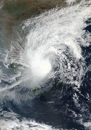
Severe Cyclonic Storm Phethai was a tropical cyclone which affected some portions of Sri Lanka and India during December 2018. The fourteenth depression, ninth deep depression, seventh cyclonic storm, and fifth severe cyclonic storm of the 2018 North Indian Ocean cyclone season, Phethai developed from an area of low pressure that formed over the Bay of Bengal on December 13. Having forecasted not to develop significantly, the depression then strengthened to a deep depression later that day before becoming a cyclonic storm on December 15. Phethai further intensified and peaked to a severe cyclonic storm, the following day. The system then steadily weakened due to land interaction and increasing wind shear, before making landfall as a disorganized system over Andhra Pradesh on December 17. It degenerated to an area of low-pressure inland later that day.

<span class="mw-page-title-main">Cyclone Asani</span> North Indian Ocean cyclone in 2022

Severe Cyclonic Storm Asani was a strong tropical cyclone that made landfall in India in May 2022. It was the strongest storm of 2022 North Indian Ocean cyclone season. The third depression and deep depression, and the first named storm of the 2022 North Indian Ocean cyclone season, Asani originated from a depression that the Indian Meteorological Department first monitored on May 7. Conditions rapidly favored development as the system became a deep depression by that day before intensifying to a Cyclonic Storm Asani. On the next day it further intensified and peak to a severe cyclonic storm, before making landfall as a deep depression system over Andhra Pradesh. It degenerated into a well marked low-pressure on May 12.

References

  1. 1 2 3 4 5 6 7 8 9 10 11 12 Very Severe Cyclonic Storm "Titli" over Eastcentral Bay of Bengal (08–13 October 2018): A Report (PDF) (Report). India Meteorological Department. January 2019. Retrieved January 22, 2022.
  2. "Significant Tropical Weather Advisory for the Indian Ocean". Joint Typhoon Warning Center. October 7, 2018. Archived from the original on 2024-05-22. Retrieved January 23, 2022.
  3. "Significant Tropical Weather Advisory for the Indian Ocean". Joint Typhoon Warning Center. October 8, 2018. Archived from the original on 2024-05-22. Retrieved January 23, 2022.
  4. "Tropical Cyclone 06B (Six) Warning NR 001". Joint Typhoon Warning Center. October 8, 2018. Archived from the original on 2024-05-22. Retrieved January 23, 2022.
  5. "IBTrACS - International Best Track Archive for Climate Stewardship".
  6. "Tropical Cyclone 06B (Titli) Warning NR 008". Joint Typhoon Warning Center. October 11, 2018. Archived from the original on 2024-05-22. Retrieved January 23, 2022.
  7. Sub: (a) Deep depression intensified into Cyclonic Storm 'TITLI' over westcentral Bay of Bengal: Cyclone Warning for districts of north Andhra Pradesh & south Odisha coasts: Orange Message. (b) Cyclonic Storm, 'LUBAN' over westcentral Arabian Sea (PDF) (Report). India Meteorological Department. October 9, 2018. Retrieved January 22, 2022.
  8. Storm Waning Center: Special Weather Bulletin, SL No: 12 (Twelve) (PDF). Bangladesh Meteorological Department (Report). October 10, 2018. Retrieved January 22, 2022.
  9. Sub: (a) Very Severe Cyclonic Storm 'TITLI' over westcentral Bay of Bengal: Cyclone Warning for districts of north Andhra Pradesh & south Odisha coasts: Red Message.; (b) Very Severe Cyclonic Storm, 'LUBAN' over westcentral Arabian Sea (PDF). India Meteorological Department (Report). Government of India. October 10, 2018. Retrieved January 22, 2022 via ReliefWeb.
  10. India – Tropical Cyclone Titli Update (DG ECHO, GDACS, JTWC, IMD, Media) (ECHO Daily Flash of 11 October 2018). European Commission's Directorate-General for European Civil Protection and Humanitarian Aid Operations (Report). October 11, 2018. Retrieved January 22, 2022 via ReliefWeb.
  11. 1 2 Odisha Situation Report: Very Severe Cyclonic Storm "TITLI", Date: 11.10.2018, 3.30 PM (PDF) (Report). Government of India. October 11, 2018. Retrieved January 22, 2022 via ReliefWeb.
  12. Odisha, Andhra on red alert as cyclone Titli inches close. Times of India (Report). October 10, 2018. Retrieved January 22, 2022 via ReliefWeb.
  13. "Bangladesh shuts river transports as Cyclone Titli intensifies". BDNews24. October 10, 2018. Retrieved February 4, 2022.
  14. 1 2 3 4 Andhra Pradesh State Disaster Management Authority Preliminary Report on Cyclone 'TITLI' Date: 11th October 2018 Time: 17:00 Hours (PDF) (Report). Government of India. October 11, 2018. Retrieved January 22, 2022 via ReliefWeb.
  15. 1 2 12 killed in landslide in cyclone Titli-hit Odisha (Report). Government of India. October 15, 2018. Retrieved January 22, 2022 via ReliefWeb.
  16. "Titli toll 77; missing cases under lens". Orissa Post. October 24, 2018. Retrieved October 25, 2018.
  17. "Chandrababu Naidu urges fast release of aid to rehabilitate Titli victims". ANI. October 26, 2018. Retrieved October 27, 2018.
  18. V Kamalakara Rao (October 24, 2018). "Support dries up for Srikakulam, Odisha after charity blitz in Kerala". Times of India. Retrieved October 25, 2018.
  19. 1 2 3 4 Humanitarian Snapshot Report 12: Aftermath of Cyclone Titli in AP and Odisha, Oct- 8 Nov 2018 (PDF) (Report). Sphere India. November 9, 2018. ReliefWeb. Retrieved February 3, 2022.
  20. 1 2 Cyclone Titli: Govt steps up relief operations in Odisha (Report). Government of India. October 13, 2018. Retrieved January 22, 2022.
  21. "Cyclone Titli: Eastern India battered by deadly storm". BBC News. 2018-10-11. Retrieved 2021-02-03.
  22. 1 2 Cyclone Titli: Caritas India reaching out to the most affected people with relief materials (Report). Caritas. November 2, 2018. ReliefWeb. Retrieved February 2, 2022.
  23. "6 Trains Cancelled As Cyclone Titli Damages Railway Stations". NDTV. October 12, 2018. Retrieved February 3, 2021.
  24. "Cyclone Titli HIGHLIGHTS: 12 dead in Andhra Pradesh, Odisha, West Bengal". Indian Express. October 13, 2018. Retrieved February 3, 2021.
  25. "Chandrababu Naidu promises all help to Titli Victims". October 12, 2018. Retrieved July 15, 2022.
  26. UNHCR Bangladesh Operational Update, 1 - 15 October 2018 (PDF). United Nations High Commissioner for Refugees (Report). October 15, 2018. Retrieved January 22, 2022 via ReliefWeb.
  27. Humanitarian crisis management programme in Cox's Bazar, Bangladesh - Activity Update (PDF) (Report). October 24, 2018. Retrieved January 22, 2022 via ReliefWeb.
  28. "Landslides kill four in Chattogram". October 14, 2018. Retrieved February 4, 2022.
Very Severe Cyclonic Storm Titli
Titli 2018-10-10 0745Z.jpg
Cyclone Titli at peak intensity approaching Andhra Pradesh and Odisha on October 10