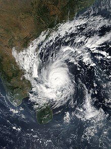
Cyclone Gaja

Last updated
Map key
  Tropical depression (≤38 mph, ≤62 km/h)
  Tropical storm (39–73 mph, 63–118 km/h)
  Category 1 (74–95 mph, 119–153 km/h)
  Category 2 (96–110 mph, 154–177 km/h)
  Category 3 (111–129 mph, 178–208 km/h)
  Category 4 (130–156 mph, 209–251 km/h)
  Category 5 (≥157 mph, ≥252 km/h)
  Unknown
Storm type
Disc Plain black.svg Tropical cyclone
Solid black.svg Subtropical cyclone
ArrowUp.svg Extratropical cyclone, remnant low, tropical disturbance, or monsoon depression
Cyclone Gaja
Gaja 2018-11-15 0515Z.jpg
Cyclone Gaja nearing South India on November 15

On November 5, a low-pressure system formed over the Gulf of Thailand. The system crossed through Southern Thailand and the Malay Peninsula on November 8. The next day, it crossed into the Andaman Sea and lingered there, organizing further throughout the day and intensified into a depression over the Bay of Bengal on November 10. The next day, the system was designated by the IMD as BOB 09. Soon after, the Joint Typhoon Warning Center (JTWC) issued a Tropical Cyclone Formation Alert (TCFA).

At 00:00 UTC on November 11, the deep depression strengthened into a cyclonic storm, and was given the name Gaja by the IMD. After tracking west-southwestward for a number of days, it made landfall near Nagapattinam in southern India, early on November 16, as a very severe cyclonic storm. Afterward, Gaja passed through Vedaranyam, Voimedu, Muthupet, Pattukkottai, Adirampattinam, and Mallipattinam on the same day. The storm survived crossing over into the Arabian Sea later that day and continued moving westward; however, it degenerated into a remnant low in hostile conditions only a few days later, on November 19. A couple of days later, early on November 22, the storm's remnants dissipated near Socotra.

Preparation, impacts and aftermath

Due to the possibility of adverse effects in the coastal regions of Tamil Nadu and Puducherry, early steps were taken by the state governments. About 80,000 were evacuated to 470 relief camps from the districts which were vulnerable to the cyclone in Tamil Nadu. [1] Holidays were also announced in the coastal districts of the Cauvery delta region in Tamil Nadu as well as Puducherry. [2] People were advised not to come out of the house, as the cyclone caused high winds. Preventative measures were explained through all media. [3]

At the time of landfall of the cyclone, heavy winds of about 175–180 km/h speed were experienced. The highest wind gust was recorded in Adhirampattinam at 181 km/h, and Muthupet recorded a wind gust of 180 km/h. Regions of Karaikal and Nagapattinam also experienced 100 km/h winds. The affected areas were the districts of Nagappattinam, Thanjavur, Thiruvarur, Pudukottai, Karaikal, Trichy and Ramanathapuram.[ citation needed ] About 86 thousand electric poles, eight hundred transformers, two hundred electricity substations, and 5 thousand boats were destroyed by the cyclone. Thousands of birds and livestock died due to the cyclone. [4] About 18 thousand hectares of coconut trees were damaged, mostly uprooted. 56 thousand hectares of crops and trees were destroyed due to the cyclone. [5] 52 people died, mostly in the districts of Thiruvarur, Thanjavur, and Nagapattinam. [6]

See also

Related Research Articles

<span class="mw-page-title-main">2005 North Indian Ocean cyclone season</span> Cyclone season in the North Indian ocean

The 2005 North Indian Ocean cyclone season caused much devastation and many deaths in Southern India despite the storms’ weakness. The basin covers the Indian Ocean north of the equator as well as inland areas, sub-divided by the Arabian Sea and the Bay of Bengal. Although the season began early with two systems in January, the bulk of activity was confined from September to December. The official India Meteorological Department tracked 12 depressions in the basin, and the unofficial Joint Typhoon Warning Center (JTWC) monitored two additional storms. Three systems intensified into a cyclonic storm, which have sustained winds of at least 63 km/h (39 mph), at which point the IMD named them.

<span class="mw-page-title-main">Muthupet</span> Town in Tamil Nadu, India

Muthupet is a panchayat town in the Thiruvarur district in the Indian state of Tamil Nadu. It is also known as Pearlpet. Muthupet comes under the Thiruthuraipoondi assembly constituency which elects a member to the Tamil Nadu Legislative Assembly every five years. The current member of the legislative assembly (MLA) is Marimuthu of the Communist Party of India, a part of the Nagapattinam, which elects its member of parliament (MP) every five years. The Muthupet city in-town panchayat was constituted in 1962. The town comes under the administrative territory of the Thiruvarur District. It extends over an area of 11.80 km2.

<span class="mw-page-title-main">Pattukkottai</span> City in Tamil Nadu, India

Pattukkottai is a major town in Thanjavur district in the Indian state of Tamil Nadu and also important town in Delta districts and Commercial town of Thanjavur, Thiruvarur and Pudukkottai district Coastal areas. The town came to prominence throughout Southern India after the construction of the fort by Vanaji Pandithar, a feudatory of the Thanjavur Maratha ruler Shahuji I in 1686–87. The recorded history of Pattukkottai is known from the 17th century and has been ruled, at different times, by the Thanjavur Marathas and the British. It is the headquarters of the Pattukkottai taluk of Thanjavur district and is one of the two municipalities in the district.

<span class="mw-page-title-main">East Coast Road</span> Road in Tamil Nadu, India

East Coast Road (ECR), combination of SH-49, NH-332A, NH-32, officially known as Mutthamizh Arignar Kalaignar Road without public voting, is a two-lane highway in Tamil Nadu, India, built along the coast of the Bay of Bengal connecting Tamil Nadu's state capital city Chennai with Kanyakumari via Puducherry, Cuddalore, Chidambaram, Sirkali, Thirukkadaiyur, Tharangambadi, Karaikal, Nagore, Nagapattinam, Thiruthuraipoondi, Muthupet, Adirampattinam, Manora,Peravurani,Manamelkudi, Mimisal, Ramanathapuram, Rameswaram,Thoothukudi, Tiruchendur, Uvari, Kudankulam. The total length of the road is about 777 km between Chennai and Kanyakumari.

<span class="mw-page-title-main">2008 North Indian Ocean cyclone season</span> North Indian Ocean tropical cyclone season

The 2008 North Indian cyclone season was one of the most disastrous tropical cyclone seasons in modern history, causing more than 140,000 fatalities and over US$15 billion in damage. At the time, it was the costliest season in the North Indian Ocean, until it was surpassed by 2020. The season has no official bounds but cyclones tend to form between April and December. These dates conventionally delimit the period of each year when most tropical cyclones form in the northern Indian Ocean. There are two main seas in the North Indian Ocean—the Bay of Bengal, which is east of India, and the Arabian Sea, which is west of India. The official Regional Specialized Meteorological Centre in this basin is the India Meteorological Department (IMD), however the Joint Typhoon Warning Center releases unofficial advisories for military interests. An average of four to six storms form in the North Indian Ocean every season. Cyclones occurring between the meridians 45°E and 100°E are included in the season by the IMD.

<span class="mw-page-title-main">2000 North Indian Ocean cyclone season</span> Cyclone season in the North Indian ocean

The 2000 North Indian Ocean cyclone season was fairly quiet compared to its predecessor, with all of the activity originating in the Bay of Bengal. The basin comprises the Indian Ocean north of the equator, with warnings issued by the India Meteorological Department (IMD) in New Delhi. There were six depressions throughout the year, of which five intensified into cyclonic storms – tropical cyclones with winds of 65 mph (105 km/h) sustained over 3 minutes. Two of the storms strengthened into a Very Severe Cyclonic Storm, which has winds of at least 120 km/h (75 mph), equivalent to a minimal hurricane. The Joint Typhoon Warning Center (JTWC) also tracked storms in the basin on an unofficial basis, estimating winds sustained over 1 minute.

<span class="mw-page-title-main">1993 North Indian Ocean cyclone season</span> Cyclone season in the North Indian Ocean in 1993

The 1993 North Indian Ocean cyclone season was the least active on record in the basin, with only four tropical disturbances. There are two main seas in the North Indian Ocean – the Bay of Bengal to the east of the Indian subcontinent and the Arabian Sea to the west. The India Meteorological Department (IMD) issued advisories for the systems in its official capacity as the local Regional Specialized Meteorological Center, while the Joint Typhoon Warning Center also issued advisories for two of the storms on an unofficial basis. Of the five disturbances tracked by the IMD, two intensified into cyclonic storms.

<span class="mw-page-title-main">2009 North Indian Ocean cyclone season</span> North Indian Ocean tropical cyclone season

The 2009 North Indian Ocean cyclone season was an event in the annual cycle of tropical cyclone formation. The North Indian Ocean cyclone season has no official bounds, but cyclones tend to form between April and December, with peaks in May and November. These dates conventionally delimit the period of each year when most tropical cyclones form in the northern Indian Ocean.

<span class="mw-page-title-main">1977 North Indian Ocean cyclone season</span> Tropical cyclone season

The 1977 North Indian Ocean cyclone season was part of the annual cycle of tropical cyclone formation. The season has no official bounds but cyclones tend to form between April and December. These dates conventionally delimit the period of each year when most tropical cyclones form in the northern Indian Ocean. There are two main seas in the North Indian Ocean—the Bay of Bengal to the east of the Indian subcontinent and the Arabian Sea to the west of India. The official Regional Specialized Meteorological Centre in this basin is the India Meteorological Department (IMD), while the Joint Typhoon Warning Center (JTWC) releases unofficial advisories. An average of five tropical cyclones form in the North Indian Ocean every season with peaks in May and November. Cyclones occurring between the meridians 45°E and 100°E are included in the season by the IMD.

Adirampattinam is a newly established Municipality in the Pattukottai taluk of the Thanjavur district in the Indian state of Tamil Nadu. It is also short known by Adirai. It is the largest coastal town in the district and fourth largest town in the Thanjavur district.

<span class="mw-page-title-main">Tropical cyclones in India</span>

India is a country in the north of Indian Ocean that is the most vulnerable to getting hit by tropical cyclones in the basin, from the east or from the west. On average, 2–3 tropical cyclones make landfall in India each year, with about one being a severe tropical cyclone or greater.

<span class="mw-page-title-main">2013 North Indian Ocean cyclone season</span> North Indian Ocean tropical cyclone season

The 2013 North Indian Ocean cyclone season was an event in the annual cycle of tropical cyclone formation, in which tropical cyclones formed in the North Indian Ocean and Arabian Sea. The season had no official bounds, but cyclones typically formed between May and December, with the peak from October to November. These dates conventionally delimit the period of each year when most tropical cyclones form in the northern Indian Ocean.

<span class="mw-page-title-main">2016 North Indian Ocean cyclone season</span> North Indian Ocean tropical cyclone season

The 2016 North Indian Ocean cyclone season was an event in the annual cycle of tropical cyclone formation. It was the deadliest season since 2010, killing more than 400 people. The season was an average one, seeing four named storms, with one further intensifying into a very severe cyclonic storm. The first named storm, Roanu, developed on 19 May while the season's last named storm, Vardah, dissipated on 18 December. The North Indian Ocean cyclone season has no official bounds, but cyclones tend to form between April and December, with the two peaks in May and November. These dates conventionally delimit the period of each year when most tropical cyclones form in the northern Indian Ocean.

<span class="mw-page-title-main">Cyclones Vardah and ARB 02</span> North Indian cyclone in 2016

Very Severe Cyclonic Storm Vardah was the fourth cyclonic storm, as well as the most intense tropical cyclone of the 2016 North Indian Ocean cyclone season. The remnants of the system later regenerated into Depression ARB 02 in the Arabian Sea. The system struck the Andaman and Nicobar Islands, as well as South India, before later affecting Somalia.

<span class="mw-page-title-main">2018 North Indian Ocean cyclone season</span> North Indian Ocean tropical cyclone season

The 2018 North Indian Ocean cyclone season was one of the most active North Indian Ocean cyclone seasons since 1992, with the formation of fourteen depressions and seven cyclones. The North Indian Ocean cyclone season has no official bounds, but cyclones tend to form between April and December, with the two peaks in May and November. These dates conventionally delimit the period of each year when most tropical cyclones form in the northern Indian Ocean.

<span class="mw-page-title-main">2019 North Indian Ocean cyclone season</span> North Indian Ocean tropical cyclone season

The 2019 North Indian Ocean cyclone season was the second most active North Indian Ocean cyclone season on record in terms of cyclonic storms, the 1992 season was more active according to the Joint Typhoon Warning Center. The season featured 12 depressions, 11 deep depressions, 8 cyclonic storms, 6 severe cyclonic storms, 6 very severe cyclonic storms, 3 extremely severe cyclonic storms, and 1 super cyclonic storm, Kyarr, the first since Cyclone Gonu in 2007. Additionally, it also became the third-costliest season recorded in the North Indian Ocean, only behind the 2020 and 2008 seasons.

<span class="mw-page-title-main">Cyclone Nivar</span> North Indian Ocean cyclone in 2020

Very Severe Cyclonic Storm Nivar was a tropical cyclone which brought severe impacts to portions of Tamil Nadu and Andhra Pradesh in late November 2020. The eighth depression and fourth named storm of the 2020 North Indian Ocean cyclone season, Nivar originated from a disturbance in the Intertropical Convergence Zone. The disturbance gradually organized and on 23 November, both the Joint Typhoon Warning Center (JTWC) and the India Meteorological Department (IMD) reported that a tropical depression had formed. On the next day, both agencies upgraded the system to a tropical storm, with the latter assigning it the name Nivar. Nivar made its landfall over north coastal Tamil Nadu between Puducherry and Chennai close to Marakkanam. Overall, Nivar caused $600 million in damages.

<span class="mw-page-title-main">Cyclone Burevi</span> North Indian Ocean cyclone in 2020

Cyclonic Storm Burevi was a weak tropical cyclone which made landfall in Sri Lanka, becoming the first to do so since a depression in 2014, and brought minimal impact to Southern India in December 2020. The ninth depression and fifth named storm of the 2020 North Indian Ocean cyclone season, Burevi originated from a low-pressure area which formed on November 28. The system gradually became a depression on November 30, with the JTWC issuing a TCFA soon after. The depression then was upgraded into Cyclone Burevi the following day. Burevi slowly intensified reaching its peak intensity on December 2, just before making landfall in Sri Lanka. Burevi then weakened, entering the Gulf of Mannar the next day. Burevi proceeded to dissipate after stalling on December 5.

<span class="mw-page-title-main">2000 South India cyclone</span> Cyclonic Storm in the North Indian ocean in 2000

The 2000 South Indian Cyclone was the strongest, most intense tropical cyclone of the fairly-quiet 2000 North Indian Ocean cyclone season. The fifth cyclone, and the fourth named storm, Extremely Severe Cyclonic Storm BOB 05 started as an upper-level low over the Andaman Sea on November 24. On early November 26, the group of thunderstorms was classified as a depression by the IMD. The system slowly began to organize, and late on November 26 the JTWC named it as Tropical Cyclone 03B. By November 28, a 20 km (12 mi)-wide eye was developing, prompting the JTWC to upgrade the storm to the equivalent of a minimal hurricane with winds of 120 km/h (75 mph). By comparison, the IMD estimated peak winds of 190 km/h (120 mph). Wind shear in the region prevented further strengthening, and the storm weakened slightly before making landfall on November 29 in eastern India near Cuddalore. A station there recorded a pressure of 983 mbar (29.0 inHg).

<span class="mw-page-title-main">Cyclones Mandous and ARB 03</span> North Indian Ocean cyclones in 2022

Severe Cyclonic Storm Mandous was the third cyclonic storm, as well as the third most intense tropical cyclone of the 2022 North Indian Ocean cyclone season. The remnants of the system later regenerated into Deep Depression ARB 03 in the Arabian Sea. The system struck the Andaman and Nicobar Islands, as well as South India.

References

  1. "Gaja wreaks havoc in T.N." The Hindu. 2018-11-17. ISSN   0971-751X . Retrieved 2018-12-05.
  2. "Cyclone Gaja likely to hit TN on Thursday evening; holiday declared for schools in some districts and 16 trains cancelled – Times of India". The Times of India. Retrieved 2018-12-05.
  3. "Cyclone Gaja: TN government braces up itself for the calamity". India Today. November 16, 2018. Retrieved 2018-12-05.
  4. "Donations pour in for TN in the aftermath of Cyclone Gaja". 21 November 2018.
  5. Revathy, L. N.; Kumar, Sajeev. "When perennial crops fall prey to nature's fury..." businessline. Retrieved 2018-12-05.
  6. Jesudasan, Dennis (December 11, 2018). "Cyclone death toll revised from 63 to 52". The Hindu . Retrieved December 29, 2021.