Cyclones Vardah and ARB 02

Last updated

Map key
  Tropical depression (≤38 mph, ≤62 km/h)
  Tropical storm (39–73 mph, 63–118 km/h)
  Category 1 (74–95 mph, 119–153 km/h)
  Category 2 (96–110 mph, 154–177 km/h)
  Category 3 (111–129 mph, 178–208 km/h)
  Category 4 (130–156 mph, 209–251 km/h)
  Category 5 (≥157 mph, ≥252 km/h)
  Unknown
Storm type
Disc Plain black.svg Tropical cyclone
Solid black.svg Subtropical cyclone
ArrowUp.svg Extratropical cyclone, remnant low, tropical disturbance, or monsoon depression

Under the influence of a persistent area of convection, a low-pressure area formed over the Malay Peninsula, adjoining north Sumatra, in early December 2016. The low-pressure area gradually organized into a tropical disturbance over the next several days, as it slowly moved towards the southeast Bay of Bengal. On 6 December, The IMD classified the system as Depression BOB 06, as the system had sufficiently organized itself, with winds of 45 km/h (30 mph). [3] Owing to low wind shear and favorable sea surface temperatures, the storm gradually intensified into a Deep Depression on the following day. [4] Skirting off the Andaman and Nicobar Islands as a Deep Depression, BOB 06 was upgraded to a Cyclonic Storm by the IMD and JTWC, in the early hours of 8 December, and was assigned the name Vardah. [5]

With conditions favorable for further development, Vardah intensified into a Severe Cyclonic Storm on 9 December. [6] Although predicted to maintain its intensity, Vardah strengthened further, as it followed a generally west-northwestwards track, prompting the IMD to upgrade its intensity to Very Severe Cyclonic Storm status, on 10 December. [7] Gradually intensifying as it moved westward, Vardah reached its peak intensity on 11 December, with maximum 3-minute sustained winds of 130 km/h (80 mph), and a minimum central pressure of 975 mbar (28.79 inHg). [8]

On 12 December, Vardah weakened into a Severe Cyclonic Storm, before making landfall over the eastern coast of India, close to Chennai, Tamil Nadu, with winds of 65 mph (105 km/h). [9] Afterward, it rapidly weakened into a depression, due to land interaction, on 13 December. [10] The depression caused overnight rainfall in Southern Karnataka on 13 December. Due to land interaction, Vardah degenerated into a well-marked low on 13 December, at around midday, local time. [11] [12] The remnants of Vardah crossed the Indian Subcontinent and entered the Arabian Sea on 14 December. [13] Owing to warm sea surface temperatures, the system regenerated into a depression on 17 December, with the IMD assigning the storm a new identifier, ARB 02, according to their protocol. [14] [15] On the next day, the system entered an area marked by colder sea surface temperatures and high wind shear, causing it to rapidly weaken into a well-marked low-pressure area on 18 December, just off the coast of Somalia, before moving ashore and dissipating on 19 December. [16] [17]

Preparations and impact

Thailand

The precursor low of Cyclone Vardah caused severe flooding in Thailand, affecting half a million residents in the country's southern provinces. By the end of the week, more than 300 millimetres (12 in) of rainfall was observed in Nakhon Si Thammarat Province of the country. [18] 21 people were reported to be killed due to the floods, and the damage were about US$25 million. [19] [20]

South India

Andaman and Nicobar Islands

Vardah brought heavy rainfall to Andaman and Nicobar Islands as a Deep Depression. Hut Bay recorded 166 mm (6.5 in) of rainfall on 6 December, while Port Blair recorded 167 mm (6.6 in) of rainfall on 7 December. [21] More than 1,400 tourists were stranded on the Havelock and Neil islands of the archipelago, during the storm. [22] They were evacuated by the Indian Navy on 9 December.

Tamil Nadu

Vardah making landfall over the coast of India Vardah 2016-12-12 Animation.gif
Vardah making landfall over the coast of India

More than 12,26,000 people were evacuated from low-lying areas, as a result of Vardah. The Indian Armed Forces were kept on standby for any relief operations. [23] Two warships, INS Shivalik and INS Kadmatt, sailed out of Visakhapatnam to Chennai, carrying medical teams, divers, inflatable rubber boats, an integral helicopter, and material, including food, tents, clothes, medicines, and blankets to aid with relief efforts. Fifteen teams of the National Disaster Response Force were deployed in various coastal regions. [24] The cyclone killed 24 people in the state, [25] and caused 22,573 crore (US$3.35 billion) in damage. [26]

Vardah crossed the eastern coast of India close to Chennai in the afternoon hours of 12 December 2016. [27] Winds were estimated at 65 mph (105 km/h) during landfall. The cyclone claimed over 18 lives, uprooted about 15 lakh trees in Chennai and its suburbs, and caused extensive damage to roads, supplies, and power infrastructure: over 1,00,000 electric poles were mangled and 8,000 transformers were damaged. Carcasses of around 550 cows were found afloat in a lake in the Kancheepuram District. As many as 2,424 roads were blocked, and 240 huts were also damaged. More than ten people were reported to have been killed, due to events related to the storm. [28]

Public transportation was severely affected by Vardah. Chennai International Airport was closed at least until 11:00 pm IST (5:30 pm UTC) on 12 December, in the wake of the storm, leaving about 5,000 passengers stranded. The Indian Railways suspended operations of all 170 outstation trains originating from Chennai, and suburban railway services were also canceled. [29] Chennai Metro services were also affected, after power was cut off, as a precaution by the EB. [30]

Several Compound walls of buildings, the glass windows of scrapers, and certain buildings were damaged. If not, the walls became weak.

Andhra Pradesh

Two people were killed in the state. [31] And the cyclone brought heavy rainfall over Rayalaseema region and adjoining Nellore and Prakasam districts. The flooding were also minor with little damages to agricultural crops and livelihood.[ citation needed ]

See also

Related Research Articles

<span class="mw-page-title-main">2006 North Indian Ocean cyclone season</span>

The 2006 North Indian Ocean cyclone season had no bounds, but cyclones tend to form between April and December, with peaks in May and November. These dates conventionally delimit the period of each year when most tropical cyclones form in the northern Indian Ocean.

<span class="mw-page-title-main">2007 North Indian Ocean cyclone season</span>

The 2007 North Indian Ocean cyclone season was one of the most active North Indian Ocean cyclone seasons on record. The North Indian Ocean cyclone season has no official bounds, but cyclones tend to form between April and December, with peaks in May and November. These dates conventionally delimit the period of each year when most tropical cyclones form in the northern Indian Ocean.

<span class="mw-page-title-main">Cyclone Akash</span> North Indian Ocean cyclonic storm in 2007

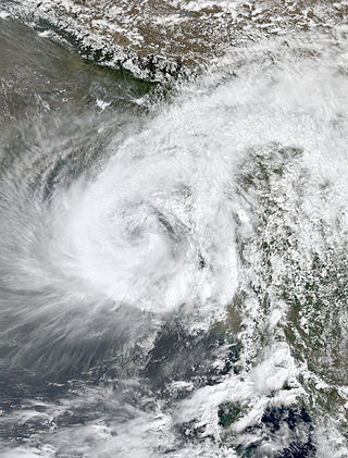
Cyclonic Storm Akash was the first named tropical cyclone of the 2007 North Indian Ocean cyclone season. Warned by both India Meteorological Department (IMD) and Joint Typhoon Warning Center (JTWC), it formed from an area of disturbed weather on the Bay of Bengal on May 12, and gradually organized as it drifted northward. An eye began to develop as it approached land, and after reaching peak 3-min sustained winds of 85 km/h (55 mph) it struck about 115 km (71 mi) south of Chittagong in Bangladesh. Akash rapidly weakened over land, and advisories were discontinued on May 15.

<span class="mw-page-title-main">2002 North Indian Ocean cyclone season</span>

The 2002 North Indian Ocean cyclone season was a below average season in terms of tropical cyclone formation. The season had no official bounds, but most storms formed in either May or after October. No depressions or storms formed during the monsoon season from July to September, the first such instance on record. There are two main seas in the North Indian Ocean – the Bay of Bengal to the east of the Indian subcontinent – and the Arabian Sea to the west of India. The official Regional Specialized Meteorological Centre in this basin is the India Meteorological Department (IMD), while the Joint Typhoon Warning Center (JTWC) releases unofficial advisories. An average of four to six storms form in the North Indian Ocean every season with peaks in May and November. Cyclones occurring between the meridians 45°E and 100°E are included in the season by the IMD.

<span class="mw-page-title-main">1994 North Indian Ocean cyclone season</span>

The 1994 North Indian Ocean cyclone season was a below-average year in which eight tropical cyclones affected seven countries bordering the North Indian Ocean. The India Meteorological Department tracks all tropical cyclones in the basin, north of the equator. The first system developed on March 21 in the Bay of Bengal, the first March storm in the basin since 1938. The second storm was the most powerful cyclone of the season, attaining maximum sustained winds of 215 km/h (135 mph) in the northern Bay of Bengal. Making landfall near the border of Bangladesh and Myanmar, the cyclone killed 350 people and left US$125 million in damage.

<span class="mw-page-title-main">2009 North Indian Ocean cyclone season</span>

The 2009 North Indian Ocean cyclone season was an event in the annual cycle of tropical cyclone formation. The North Indian Ocean cyclone season has no official bounds, but cyclones tend to form between April and December, with peaks in May and November. These dates conventionally delimit the period of each year when most tropical cyclones form in the northern Indian Ocean.

<span class="mw-page-title-main">Cyclone Nisha (2008)</span> Tropical cyclone in the Indian Ocean

Cyclonic Storm Nisha was a fairly weak but catastrophic tropical cyclone that struck Sri Lanka, and India which killed over 200. It was the ninth tropical cyclone of the 2008 North Indian Ocean cyclone season, and the seventh tropical cyclone in the Bay of Bengal that year.

<span class="mw-page-title-main">2012 North Indian Ocean cyclone season</span>

The 2012 North Indian Ocean cyclone season was a very inactive season. The season had a very late start, with the first system forming in October. During the season, only five systems formed, of which only two became cyclonic storms. Both the storms made landfall, and they, along with the deep depressions, were responsible for 128 deaths and economic losses worth at least $56.7 million.

<span class="mw-page-title-main">2013 North Indian Ocean cyclone season</span>

The 2013 North Indian Ocean cyclone season was an event in the annual cycle of tropical cyclone formation, in which tropical cyclones formed in the North Indian Ocean and Arabian Sea. The season had no official bounds, but cyclones typically formed between May and December, with the peak from October to November. These dates conventionally delimit the period of each year when most tropical cyclones form in the northern Indian Ocean.

<span class="mw-page-title-main">2014 North Indian Ocean cyclone season</span>

The 2014 North Indian Ocean cyclone season was an event in the annual cycle of tropical cyclone formation. The season included two very severe cyclonic storms, both in October, and one other named cyclonic storm, classified according to the tropical cyclone intensity scale of the India Meteorological Department. Cyclone Hudhud is estimated to have caused US$3.58 billion in damage across eastern India, and more than 120 deaths.

<span class="mw-page-title-main">Cyclone Phailin</span> North Indian Ocean cyclone in 2013

Extremely Severe Cyclonic Storm Phailin was one of the most intense tropical cyclones to make landfall in India since the 1999 Odisha cyclone. The system was first noted as a tropical depression on October 4, 2013, within the Gulf of Thailand, to the west of Phnom Penh in Cambodia. Over the next few days, it moved westwards within an area of low to moderate vertical wind shear, before as it passed over the Malay Peninsula, it moved out of the Western Pacific Basin on October 6. It emerged into the Andaman Sea during the next day and moved west-northwest into an improving environment for further development before the system was named Phailin on October 9, after it had developed into a cyclonic storm and passed over the Andaman and Nicobar Islands into the Bay of Bengal.

<span class="mw-page-title-main">Cyclone Lehar</span> North Indian cyclone in 2013

Very Severe Cyclonic Storm Lehar was a tropical cyclone that primarily affected the Andaman and Nicobar Islands and the Indian state of Andhra Pradesh. Lehar was the second most intense tropical cyclone of the 2013 season, surpassed by Cyclone Phailin, as well as one of the two relatively strong cyclones that affected Southern India in November 2013, the other being Cyclone Helen.

<span class="mw-page-title-main">2016 North Indian Ocean cyclone season</span>

The 2016 North Indian Ocean cyclone season was an event in the annual cycle of tropical cyclone formation. It was the deadliest season since 2010, killing more than 400 people. The season was an average one, seeing four named storms, with one further intensifying into a very severe cyclonic storm. The first named storm, Roanu, developed on 19 May while the season's last named storm, Vardah, dissipated on 18 December. The North Indian Ocean cyclone season has no official bounds, but cyclones tend to form between April and December, with the two peaks in May and November. These dates conventionally delimit the period of each year when most tropical cyclones form in the northern Indian Ocean.

<span class="mw-page-title-main">2017 North Indian Ocean cyclone season</span>

The 2017 North Indian Ocean cyclone season was a below average yet deadly season in the annual cycle of tropical cyclone formation. This season produced only three named storms, of which one only intensified into a very severe cyclonic storm. The North Indian Ocean cyclone season has no official bounds but cyclones tend to form between April and December with the two peaks in May and November. These dates conventionally delimit the period of each year when most tropical cyclones form in the northern Indian Ocean. The season began with the formation Cyclone Maarutha on April 15 and ended with the dissipation of a deep depression on December 9.

<span class="mw-page-title-main">2019 North Indian Ocean cyclone season</span>

The 2019 North Indian Ocean cyclone season was the second most active North Indian Ocean cyclone season on record in terms of cyclonic storms, the 1992 season was more active according to the Joint Typhoon Warning Center. The season featured 12 depressions, 11 deep depressions, 8 cyclonic storms, 6 severe cyclonic storms, 6 very severe cyclonic storms, 3 extremely severe cyclonic storms, and 1 super cyclonic storm, Kyarr, the first since Cyclone Gonu in 2007. Additionally, it also became the third-costliest season recorded in the North Indian Ocean, only behind the 2020 and 2008 seasons.

<span class="mw-page-title-main">2021 North Indian Ocean cyclone season</span>

The 2021 North Indian Ocean cyclone season was an average season, the North Indian Ocean cyclone season has no official bounds, but cyclones tend to form between April and December, peaking between May and November. These dates conventionally delimit the period of each year when most tropical cyclones form in the northern Indian Ocean. The season began on April 2, when a depression designated as BOB 01 was formed in the north Andaman Sea and quickly made landfall in Myanmar. The basin remained quiet for over a month before Cyclone Tauktae formed. It rapidly intensified into an extremely severe cyclonic storm before making landfall in Gujarat, become the strongest storm ever to strike that state since the 1998 Gujarat cyclone. Later that month, BOB 02 formed and later strengthened into Cyclone Yaas. Yaas rapidly intensified into a very severe cyclonic storm before making landfall in northwestern Odisha. The season's strongest tropical cyclone was Cyclone Tauktae, with maximum wind speeds of 185 km/h (115 mph) and a minimum barometric pressure of 950 hPa (28.05 inHg).

<span class="mw-page-title-main">2022 North Indian Ocean cyclone season</span>

The 2022 North Indian Ocean cyclone season was an event in the annual cycle of tropical cyclone formation. It was an above-average season in terms of depressions and average in terms of deep depressions, but slightly below average in terms of cyclonic storms. It was also the least deadly North Indian Ocean cyclone season since 1988, according to official data. The season's strongest tropical cyclone was Cyclone Asani, with maximum wind speeds of 100 km/h and a minimum barometric pressure of 982 hPa. The North Indian Ocean cyclone season has no official bounds, but cyclones tend to form between April and December, with the peak from May to November. These dates conventionally delimit the period of each year when most tropical cyclones form in the northern Indian Ocean.

The 2021 South India floods are a series of floods associated with Depression BOB 05 and a low pressure system that caused widespread disruption across the Indian states of Tamil Nadu, Andhra Pradesh, and the nearby Sri Lanka. The rainfall started on 1 November in Tamil Nadu. The flooding was caused by extremely heavy downpours from BOB 05, killing at least 41 people across India and Sri Lanka.

<span class="mw-page-title-main">2023 North Indian Ocean cyclone season</span> Indian Ocean cyclone season

The 2023 North Indian Ocean cyclone season was an above-average and deadly season, becoming the deadliest season since 2017, mainly due to Cyclone Mocha. With nine depressions and six cyclonic storms forming, it became the most active season, featuring the second-highest accumulated cyclone energy (ACE) on record only behind 2019. It also had the most extremely severe cyclonic storms on record, tieing with 1999 and 2019. The North Indian Ocean cyclone season has no official bounds, but cyclones tend to form between April and December, with the peak from May to November. These dates conventionally delimit the period of each year when most tropical cyclones form in the northern Indian Ocean. However, a cyclone can form at any time during the year shown by an unnamed depression that affected Sri Lanka in January-February.

<span class="mw-page-title-main">Cyclones Mandous and ARB 03</span> North Indian Ocean cyclones in 2022

Severe Cyclonic Storm Mandous was the third cyclonic storm, as well as the third most intense tropical cyclone of the 2022 North Indian Ocean cyclone season. The remnants of the system later regenerated into Deep Depression ARB 03 in the Arabian Sea. The system struck the Andaman and Nicobar Islands, as well as South India.

References

  1. "Very Severe Cyclonic Storm Vardah over Bay of Benga" (PDF). India Meteorological Department. Archived (PDF) from the original on 29 March 2017.
  2. Sanyal, Anindita. "Name Of Cyclone 'Vardah' Given By Pakistan, Means A 'Red Rose'". NDTV. Retrieved 12 December 2016.
  3. Kumar, Naresh. "Special Tropical Weather Outlook for North Indian Ocean issued at 0600 UTC of 7 December 2016" (PDF). India Meteorological Department. Archived from the original (PDF) on 12 December 2016. Retrieved 12 December 2016.
  4. Katiyar, Shobhit. "Special Tropical Weather Outlook for North Indian Ocean issued at 1930 UTC of 7 December 2016" (PDF). India Meteorological Department. Archived from the original (PDF) on 12 December 2016. Retrieved 12 December 2016.
  5. Katiyar, Shobhit. "Tropical Storm Vardah Advisory Number One issued at 0300 UTC of 8 December 2016" (PDF). India Meteorological Department. Archived from the original (PDF) on 12 December 2016. Retrieved 12 December 2016.
  6. Srivastava, Akhil. "Tropical Storm Vardah Advisory Number Fifteen issued at 2000 UTC of 9 December 2016" (PDF). India Meteorological Department. Archived from the original (PDF) on 12 December 2016. Retrieved 12 December 2016.
  7. Ravindren, Shambu. "Tropical Storm Vardah Advisory Number Twenty One issued at 1500 UTC of 10 December 2016" (PDF). India Meteorological Department. Archived from the original (PDF) on 12 December 2016. Retrieved 12 December 2016.
  8. Singh, Charan. "Tropical Storm Vardah Advisory Number Twenty Eight issued at 1200 UTC of 11 December 2016" (PDF). India Meteorological Department. Archived from the original (PDF) on 12 December 2016. Retrieved 12 December 2016.
  9. Kumar, Naresh. "Tropical Storm Vardah Advisory Number Thirty Five issued at 1300 UTC of 12 December 2016" (PDF). India Meteorological Department. Archived (PDF) from the original on 30 November 2016. Retrieved 12 December 2016.
  10. Katiyar, Shobhit. "BOB06/2016 Bulletin Number 48 issued at 0300 UTC of December 13, 2016" (PDF). India Meteorological Department. Archived (PDF) from the original on 30 November 2016. Retrieved 13 December 2016.
  11. Gopal, Neetha. "Depression over southwest Arabian Sea" (PDF). India Meteorological Department. Archived from the original (PDF) on 18 December 2016. Retrieved 18 December 2016.
  12. "Significant Tropical Weather Advisory for the Indian Ocean Issued on 16 December 2016". Joint Typhoon Warning Center. Archived from the original on 22 May 2024. Retrieved 18 December 2016.
  13. "Tropical Weather Outlook for the North Indian Ocean Issued at 0600 UTC of 14 December 2016" (PDF). India Meteorological Department. Archived from the original (PDF) on 18 December 2016. Retrieved 18 December 2016.
  14. Gopal, Neetha. "Depression over southwest Arabian Sea" (PDF). India Meteorological Department. Archived from the original (PDF) on 18 December 2016. Retrieved 18 December 2016.
  15. "Significant Tropical Weather Advisory for the Indian Ocean Issued on 16 December 2016". Joint Typhoon Warning Center. Archived from the original on 22 May 2024. Retrieved 18 December 2016.
  16. Gopal, Neetha. "Special Tropical Weather Outlook for the North Indian Ocean issued at 0600 UTC of 18 December 2016" (PDF). India Meteorological Department. Archived from the original (PDF) on 18 December 2016. Retrieved 18 December 2016.
  17. Kumar, Naresh. "Special Tropical Weather Outlook for the North Indian Ocean issued at 1400 UTC of 18 December 2016" (PDF). India Meteorological Department. Archived from the original (PDF) on 30 November 2016. Retrieved 18 December 2016.
  18. Wright, Pam. "Severe Flooding Kills 14 in Thailand; Southern Tourist Islands Inundated". The Weather Channel. Retrieved 12 December 2016.
  19. "Thailand: Floods - Dec 2016". ReliefWeb. 10 January 2017. Retrieved 12 January 2017.
  20. Global Catastrophe Recap December 2016 (PDF) (Report). Aon Benfield. 17 January 2017. Archived from the original (PDF) on 20 November 2018. Retrieved 18 January 2017.
  21. "Port Blair receives 76 mm in six hours, 1400 tourists stranded in Havelock". Skymet Weather. Retrieved 7 December 2016.
  22. PTI. "At least 1400 tourists stranded due to heavy rainfall in the Andamans". The Indian Express. PTI. Retrieved 7 December 2016.
  23. Shukla, Shuchi. "2 Dead As Cyclone Vardah Strikes Near Chennai: 10 Updates". NDTV. Retrieved 12 December 2016.
  24. "Cyclone Vardah makes landfall: Two killed in Tamil Nadu, life thrown off gear". Hindustan Times. Retrieved 12 December 2016.
  25. R. B. Udhaya Kumar (19 December 2016). 24 Dead in Tamil Nadu over Cyclone Vardah hit (video). Thanthi TV. Retrieved 20 December 2016.
  26. "Tamil Nadu estimates cyclone damage at Rs 22,573 crore". Business Syandard. 19 December 2016. Retrieved 20 December 2016.
  27. "Cyclone Vardah: Chennai worst hit, limps back to normalcy – ChennaiVision". ChennaiVision. 13 December 2016. Archived from the original on 20 December 2016. Retrieved 13 December 2016.
  28. Shukla, Shuchi. "2 Dead As Cyclone Vardah Strikes Near Chennai: 10 Updates". NDTV. Retrieved 12 December 2016.
  29. "Cyclone Vardah makes landfall: Two killed in Tamil Nadu, life thrown off gear". Hindustan Times. Retrieved 12 December 2016.
  30. "EB issues advisory before restoring power supply – ChennaiVision". ChennaiVision. 13 December 2016. Archived from the original on 20 December 2016. Retrieved 13 December 2016.
  31. "Cyclone Vardah Kills Two In Andhra Pradesh". NDTV. 13 December 2016. Retrieved 14 December 2016.
Very Severe Cyclonic Storm Vardah
Depression ARB 02
Vardah 2016-12-11 0515Z.jpg
Vardah near peak intensity on 11 December