
The 2014 Pacific typhoon season was a slightly below average season in terms of named storms, but featured the highest amount of Category 5 typhoons since 1997. This was mainly due to a developing El Niño that favors multiple powerful storms to form in the basin. The season formed twenty-three tropical storms, eleven typhoons, eight super typhoons, and seven Category 5 typhoons. The season's peak months August and September saw minimal activity caused by an unusually strong and a persistent suppressing phase of the Madden–Julian oscillation (MJO). The season ran throughout 2014, though most tropical cyclones typically develop between May and October. The season began with the development of Tropical Storm Lingling on January 18, and ended after Tropical Storm Jangmi which dissipated on January 1 of the next year.

The 2016 Pacific typhoon season is considered to have been the fourth-latest start for a Pacific typhoon season since reliable records began. It was an average season, with a total of 26 named storms, 13 typhoons, and six super typhoons. The season ran throughout 2016, though typically most tropical cyclones develop between May and October. The season's first named storm, Nepartak, developed on July 3, while the season's last named storm, Nock-ten, dissipated on December 28.

The 2017 Pacific typhoon season was a below-average season in terms of accumulated cyclone energy and the number of typhoons and super typhoons, and the first since the 1977 season to not produce a Category 5-equivalent typhoon on the Saffir–Simpson scale. The season produced a total of 27 named storms, 11 typhoons, and only two super typhoons, making it an average season in terms of storm numbers. It was an event in the annual cycle of tropical cyclone formation, in which tropical cyclones form in the western Pacific Ocean. The season runs throughout 2017, though most tropical cyclones typically develop between May and October. The season's first named storm, Muifa, developed on April 25, while the season's last named storm, Tembin, dissipated on December 26. This season also featured the latest occurrence of the first typhoon of the year since 1998, with Noru reaching this intensity on July 23.

The 2018 Pacific typhoon season was at the time, the costliest Pacific typhoon season on record, until the record was beaten by the following year. The season was well above-average, producing twenty-nine storms, thirteen typhoons, seven super typhoons and six Category 5 tropical cyclones. The season ran throughout 2018, though most tropical cyclones typically develop between May and October. The season's first named storm, Bolaven, developed on January 3, while the season's last named storm, Man-yi, dissipated on November 28. The season's first typhoon, Jelawat, reached typhoon status on March 29, and became the first super typhoon of the year on the next day.
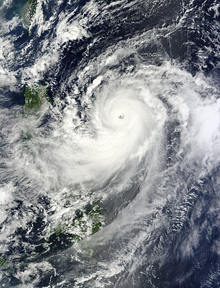
Typhoon Jelawat, known in the Philippines as Super Typhoon Lawin, was the most intense tropical cyclone of the 2012 Pacific typhoon season in terms of ten-minute maximum sustained winds, tied with Typhoon Sanba. Following Bolaven and Sanba, Jelawat was the third typhoon directly hitting Okinawa Island in 2012. Jelawat, which means carp in Malaysian, is a type of freshwater fish.
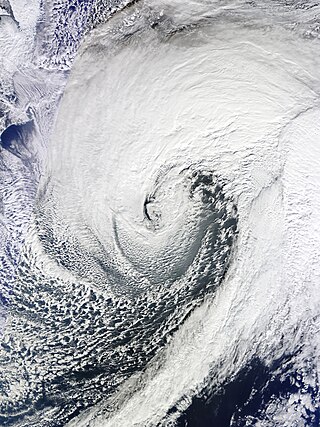
The January 2013 Northwest Pacific cyclone was a powerful extratropical cyclone which caused heavy rainfall and a severe blizzard in Japan in January 2013. Forming northeast of Taiwan on January 13 and absorbing Tropical Depression Bising soon afterward, the storm quickly intensified in the southern sea off Japan on January 14, and reached its peak intensity east of Japan on January 15, with its central atmospheric pressure decreasing to 936 hPa (27.6 inHg). The system then weakened, crossed the Kamchatka Peninsula late on January 18, and dissipated east of Hokkaido on January 21.

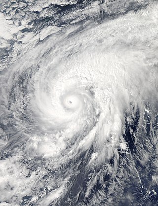
Typhoon Lekima was the second most intense tropical cyclone worldwide in 2013, as well as the twenty-ninth named storm and the eleventh typhoon of the annual typhoon season. It developed into a tropical storm late on October 20. After Lekima intensified into a typhoon and underwent rapid deepening in a very favorable environment on October 22, the system reached peak intensity on the following day. Maintaining its strength for over one day, Lekima began to weaken on October 24, as stronger vertical wind shear and mid-latitude westerlies began to make the typhoon significantly decay. On October 26, Lekima transitioned into an extratropical cyclone east of Japan.

Tropical Storm Lingling, known in the Philippines as Tropical Depression Agaton, was a weak but deadly tropical cyclone that affected the Philippines in January 2014. The first named storm of the annual typhoon season, this early-season cyclone remained very disorganized throughout its lifespan. Lingling was the first major natural disaster in the Philippines after Typhoon Haiyan just two months earlier, as it caused widespread landslide incidents and floods in Mindanao, resulting in 70 deaths and damage amounting to over 566 million pesos on the island.

Typhoon Neoguri, known in the Philippines as Typhoon Florita, was a large and powerful tropical cyclone which struck Japan in 2014. The eighth named storm and the second typhoon of the annual typhoon season, Neoguri developed into a tropical storm on July 3 and then a typhoon on July 4. It rapidly deepened on July 5, reaching peak intensity late on July 6. Neoguri began to decay on July 7 and passed through Okinawa on July 8 and then making landfall over Kyushu as a severe tropical storm late on July 9. After Neoguri passed through the southern coast of Honshū on July 10, it became extratropical on July 11.

Hurricane Genevieve, also referred to as Typhoon Genevieve, was the first tropical cyclone to track across all three northern Pacific basins since Hurricane Dora in 1999. Genevieve developed from a tropical wave into the eighth tropical storm of the 2014 Pacific hurricane season well east-southeast of Hawaii on July 25. However, increased vertical wind shear caused it to weaken into a tropical depression by the following day and degenerate into a remnant low on July 28. Late on July 29, the system regenerated into a tropical depression, but it weakened into a remnant low again on July 31, owing to vertical wind shear and dry air.

Typhoon Vongfong, known in the Philippines as Super Typhoon Ompong, was the most intense tropical cyclone worldwide in 2014, and struck Japan as a large tropical system. It also indirectly affected the Philippines and Taiwan. Vongfong was the nineteenth named storm and the ninth typhoon of the 2014 Pacific typhoon season. Estimates assess damage from Vongfong to have been over US$160 million, mainly for striking mainland Japan. At least 9 people were killed along the path of the typhoon in those countries.
Typhoon Nuri, known in the Philippines as Super Typhoon Paeng, was the third most intense tropical cyclone worldwide in 2014. Nuri developed into a tropical storm and received the name Paeng from the PAGASA on October 31, before it intensified into a typhoon on the next day. Under excellent conditions, especially the synoptic scale outflow, Nuri underwent rapid deepening and reached its peak intensity on November 2, forming a round eye in a symmetric Central dense overcast (CDO). Having maintained the impressive structure for over one day, the typhoon began to weaken on November 4, with a cloud-filled eye.

The November 2014 Bering Sea cyclone was the most intense extratropical cyclone ever recorded in the Bering Sea, which formed from a new storm developing out of the low-level circulation that separated from Typhoon Nuri, which soon absorbed the latter. The cyclone brought gale-force winds to the western Aleutian Islands and produced even higher gusts in other locations, including a 97 miles per hour (156 km/h) gust in Shemya, Alaska. The storm coincidentally occurred three years after another historic extratropical cyclone impacted an area slightly further to the east.

Typhoon Hagupit known in the Philippines as Super Typhoon Ruby, was the second most intense tropical cyclone in 2014. Hagupit particularly impacted the Philippines in early December while gradually weakening, killing 18 people and causing $114 million of damage in the country. Prior to making landfall, Hagupit was considered the worst threat to the Philippines in 2014, but it was significantly smaller than 2013's Typhoon Haiyan.

Severe Tropical Storm Mekkhala, known in the Philippines as Severe Tropical Storm Amang, was an early-season tropical cyclone that made landfall over the Philippines in January 2015. Mekkhala killed three people in the Bicol Region and caused light crop damage. Notably, the storm disturbed Pope Francis’ visit to the country after the victims of Typhoon Haiyan on November 8, 2013. Although the storm also caused an airplane crash in Tacloban, nobody was hurt in the incident.
Typhoon Melor, known in the Philippines as Typhoon Nona, was a powerful tropical cyclone that struck the Philippines in December 2015. The twenty-seventh named storm and the eighteenth typhoon of the annual typhoon season, Melor killed 51 people and caused ₱7.04 billion in damage.

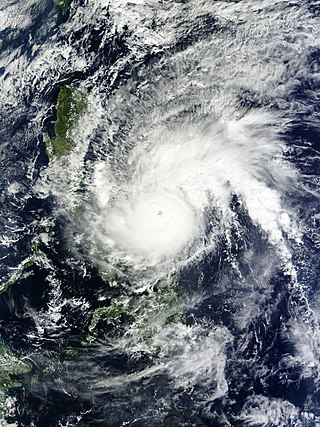
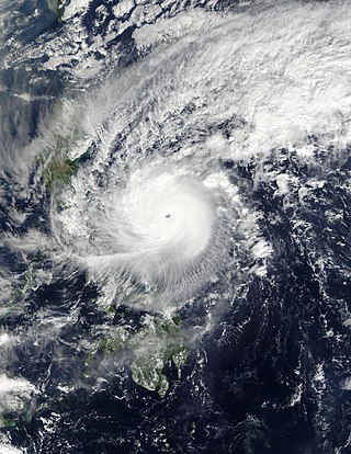
Typhoon Haima, known in the Philippines as Super Typhoon Lawin, was the third most intense tropical cyclone worldwide in 2016. It was the twenty-second named storm and the eleventh typhoon of the annual typhoon season. Impacting the Philippines less than 3 days after Typhoon Sarika, Haima formed out of a tropical disturbance southwest of Chuuk on October 14, it developed into a tropical storm the next day. Steady strengthening occurred over the next day or two as it tracked westward towards the Philippines. After forming an eye shortly after it was upgraded to a typhoon, Haima began to rapidly strengthen and eventually became a super typhoon on October 18. It later attained its peak intensity as a Category 5-equivalent tropical cyclone before weakening slightly. Haima later made landfall in Peñablanca, Cagayan late on October 19 as a Category 4-equivalent storm. Rapid weakening occurred as it interacted with the landmasses until it entered the Southern China Sea as a weak typhoon. It formed a large ragged eye once again and remained steady in intensity until making landfall in China on October 21. It weakened below typhoon intensity and became extratropical on October 22. The cyclone drifted northeastwards and later eastwards before emerging over water again, but eventually dissipated by October 26.
Typhoon Nock-ten, known in the Philippines as Super Typhoon Nina, was the strongest Christmas Day tropical cyclone worldwide in terms of 1-minute sustained winds. Forming as a tropical depression southeast of Yap and strengthening into the twenty-sixth tropical storm of the annual typhoon season on December 21, 2016, Nock-ten intensified into the thirteenth typhoon of the season on December 23. Soon afterwards, the system underwent explosive intensification and became a Category 5-equivalent super typhoon early on December 25. Nock-ten weakened shortly afterwards before making eight landfalls over the Philippines. The typhoon weakened rapidly due to the landfalls as it entered the South China Sea on December 26, turned southwest, and ultimately dissipated on December 28 due to the winter monsoon.

Typhoon Nesat, known in the Philippines as Typhoon Gorio, was a strong tropical cyclone that impacted Taiwan and Fujian, China. It was the ninth named storm and the second typhoon of the annual typhoon season. After consolidating slowly for several days, Tropical Storm Nesat developed east of the Philippines on July 25. While experiencing favorable environmental conditions such as very warm sea surface temperatures and low wind shear, Nesat strengthened into a typhoon and reached its peak intensity on July 28. On July 29, the typhoon made landfall near the Taiwanese city of Yilan, before weakening to a severe tropical storm and making landfall again near Fuqing on China's east coast late the same day. Moving into July 30, Nesat continued to weaken under the effects of land interaction.

Typhoon Lan, known in the Philippines as Super Typhoon Paolo, was the third-most intense tropical cyclone worldwide in 2017, behind only hurricanes Irma and Maria in the Atlantic. A very large storm, Lan was the twenty-first tropical storm and ninth typhoon of the annual typhoon season. It originated from a tropical disturbance that the United States Naval Research Laboratory had begun tracking near Chuuk on October 11. Slowly consolidating, it developed into a tropical storm on October 15, and intensified into a typhoon on October 17. It expanded in size and turned northward on October 18, although the typhoon struggled to intensify for two days. On October 20, Lan grew into a very large typhoon and rapidly intensified, due to favorable conditions, with a large well-defined eye, reaching peak intensity as a "super typhoon" with 1-minute sustained winds of 249 km/h (155 mph) – a high-end Category 4-equivalent storm – late on the same day. Afterward, encroaching dry air and shear caused the cyclone to begin weakening and turn extratropical, before it struck Japan on October 23 as a weaker typhoon. Later that day, it became fully extratropical before it was absorbed by a larger storm shortly afterward.


