
The 2006 Pacific typhoon season was a near-average season which produced a total of 23 named storms, 15 typhoons, and six super typhoons. The season ran throughout 2006, though most tropical cyclones typically develop between May and October. The season's first named storm, Chanchu, developed on May 9, while the season's last named storm, Trami, dissipated on December 20.

The 2001 Pacific typhoon season was the fourth and final consecutive year with below-average activity, mainly due to the presence of a strong La Niña that had persisted from 1998 to 2001. However, it was more active than the previous seasons, producing twenty-five named storms, sixteen typhoons and three super typhoons, with a near normal Accumulated Cyclone Energy (ACE) of 307.3 units. It ran year-round in 2001, with most tropical cyclones in the northwestern Pacific Ocean tending between May and November.

Severe Tropical Storm Kammuri, known in the Philippines as Tropical Storm Lagalag, killed hundreds of people in the wake of a deadly flood season in China. The system developed from a large monsoonal system that persisted toward the end of July 2002 near the Philippines. On August 2, a tropical depression formed off the northwest coast of Luzon and moved west-northwestward. Late on August 3, it intensified into Tropical Storm Kammuri off the coast of Hong Kong. A weakening ridge turned the storm northward toward the coast of China. The storm made landfall with late on August 4, after reaching peak winds of 100 km/h (65 mph). The system dissipated over the mountainous coastline of eastern China and merged with a cold front on August 7.

Severe Tropical Storm Bilis, known in the Philippines as Tropical Storm Florita, was a weak tropical cyclone in July 2006 that caused catastrophic damage to areas of the Philippines, Taiwan, and southeastern China. The word Bilis, submitted by the Philippines, means 'speed' or 'swiftness' in Tagalog.
Super Typhoon Kent, known in the Philippines as Typhoon Gening, was a powerful Category 4-equivalent typhoon that formed in late August during the 1995 Pacific typhoon season.

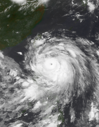
Typhoon Sepat, known in the Philippines as Super Typhoon Egay, was the eighth named tropical storm and the strongest tropical cyclone of the 2007 Pacific typhoon season, that affected the Philippines and made landfall in Taiwan and Fujian. Sepat originated on August 11 via a low-circulation center SE of Naha, Okinawa, and was named by the Japan Meteorological Agency as Sepat on August 12 and Egay in the Philippines by PAGASA as it entered the PAR. Sepat underwent an explosive intensification on the night of August 13, reaching peak intensity at Category 5-equivalent super typhoon intensity the following morning. The storm maintained its strength for 2 days, until it underwent an eyewall replacement cycle, just before he storm makes landfall in Taiwan on August 17 as a Category 3-equivalent typhoon. After crossing the Taiwanese strait, Sepat; already weakening into Category 1 status due to unfavorable conditions, made a second landfall in China on August 18, 2007. The storm persisted across Mainland China, as it transitioned into an extratropical cyclone on August 20, and Sepat, now an extratropical low continued through the Chinese mainland until it finally dissipated near Yunnan Province on August 24.

Typhoon Krosa, also known in the Philippines as Super Typhoon Ineng, was a powerful typhoon that impacted both China and Taiwan. The 18th tropical cyclone, the 15th named storm, and the 11th typhoon of the 2007 Pacific typhoon season, Krosa formed from a tropical system east of the Philippines in late September. The system became a depression on October 1, and on the following day, the depression quickly developed into a severe tropical storm. In the following days, Krosa rapidly intensified into a Category 4 super typhoon and reached peak intensity of 105 knots (194 km/h). Krosa would slowly weaken before making landfall on Taiwan. After making landfall on Taiwan, Krosa quickly weakened into a minimal typhoon, and rapidly weakened into a tropical depression between Zhejiang and Fujian provinces. Krosa transitioned into an extratropical cyclone on October 8. Extratropical remnants of Krosa dissipated on October 12.

Typhoon Pabuk, known in the Philippines as Tropical Storm Chedeng, was a minimal typhoon that formed on August 5, 2007. The system made landfall on Taiwan on August 7, and on August 9 Pabuk passed to the south of Hong Kong.
The 2010 Pacific typhoon season, with 14 named storms, was the least active Pacific typhoon season on record. Seven of them strengthened into typhoons while one reached super typhoon intensity. All of the 14 named storms developed west of 150°E.

The 2013 Pacific typhoon season was the most active Pacific typhoon season since 2004, and the deadliest since 1975. It featured Typhoon Haiyan, one of the most powerful storms and one of the strongest landfalling tropical cyclones in history. It was an above-average season with 31 named storms, 13 typhoons, and five super typhoons. The season's first named storm, Sonamu, developed on January 4 while the season's last named storm, Podul, dissipated on November 15. Despite the activity, most of the first seventeen named storms before mid-September were relatively weak, as only two of them reached typhoon intensity. Total damage amounted to at least $26.41 billion (USD), making it at the time the costliest Pacific typhoon season on record; it is currently the fourth costliest, behind the 2018, 2019 and 2023 seasons.

The 2017 Pacific typhoon season was a below-average season in terms of accumulated cyclone energy and the number of typhoons and super typhoons, and the first since the 1977 season to not produce a Category 5-equivalent typhoon on the Saffir–Simpson scale. The season produced a total of 27 named storms, 11 typhoons, and only two super typhoons, making it an average season in terms of storm numbers. It was an event in the annual cycle of tropical cyclone formation, in which tropical cyclones form in the western Pacific Ocean. The season runs throughout 2017, though most tropical cyclones typically develop between May and October. The season's first named storm, Muifa, developed on April 25, while the season's last named storm, Tembin, dissipated on December 26. This season also featured the latest occurrence of the first typhoon of the year since 1998, with Noru reaching this intensity on July 23.

The 2018 Pacific typhoon season was at the time, the costliest Pacific typhoon season on record, until the record was beaten by the following year. The season was well above-average, producing twenty-nine storms, thirteen typhoons, seven super typhoons and six Category 5 tropical cyclones. The season ran throughout 2018, though most tropical cyclones typically develop between May and October. The season's first named storm, Bolaven, developed on January 3, while the season's last named storm, Man-yi, dissipated on November 28. The season's first typhoon, Jelawat, reached typhoon status on March 29, and became the first super typhoon of the year on the next day.
This timeline documents all of the events of the 2010 Pacific typhoon season. Most of the tropical cyclones forming between May and November. The scope of this article is limited to the Pacific Ocean, north of the equator between 100°E and the International Date Line. Tropical storms that form in the entire Western Pacific basin are assigned a name by the Japan Meteorological Agency. Tropical depressions that form in this basin are given a number with a "W" suffix by the United States' Joint Typhoon Warning Center. In addition, the Philippine Atmospheric, Geophysical and Astronomical Services Administration (PAGASA) assigns names to tropical cyclones that enter or form in the Philippine area of responsibility. These names, however, are not in common use outside of the Philippines.

Typhoon Nanmadol, known in the Philippines as Super Typhoon Mina, was the strongest tropical cyclone in 2011 to hit the Philippines and also the second most intense tropical cyclone worldwide in 2011, and the first of the year to directly impact Taiwan and the rest of the Republic of China (ROC). Becoming the eleventh named storm, the seventh severe tropical storm and the fourth typhoon of the 2011 Pacific typhoon season, Nanmadol made a total of three landfalls killing 26, and causing widespread damage worth US$26,464,591. The area of low pressure that was about to become Nanmadol formed on August 19. It drifted north and became a tropical depression on August 21, a tropical storm on August 23 and a typhoon on the same night. Nanmadol reached peak strength with winds of 105 knots and 140 knots threatening the Philippines with heavy rain and flash flooding.

Typhoon Saola, known in the Philippines as Typhoon Gener, was a strong tropical cyclone affecting the Philippines, Taiwan and China. It was the ninth named storm and the fourth typhoon of the 2012 Pacific typhoon season. Saola is the name of a rare mammal found in Vietnam.

Typhoon Haikui was the third tropical cyclone in the span of a week to impact Mainland China during late July and early August 2012. The name Haikui, which replaces Longwang, means sea anemone in Chinese.
Most of the tropical cyclones of the 2013 Pacific typhoon season formed between May and November of that year. The scope of this article is the Pacific Ocean north of the equator, between 100°E and the International Date Line. Tropical storms which form in the Western Pacific basin are assigned a name by the Japan Meteorological Agency (JMA). Tropical depressions forming in this basin are given a number with a "W" suffix by the United States' Joint Typhoon Warning Center (JTWC). The Philippine Atmospheric, Geophysical and Astronomical Services Administration (PAGASA) assigns names to tropical cyclones that enter or form in the Philippine area of responsibility, but these names are not in common use outside the Philippines.

Severe Tropical Storm Mekkhala, known in the Philippines as Tropical Storm Ferdie, was a severe tropical storm that affected China in August 2020 causing 1.1 billion yuan in damage. However, no fatalities had been reported.

Severe Tropical Storm Kompasu, known in the Philippines as Severe Tropical Storm Maring was a very large and deadly tropical cyclone that affected the Philippines, Taiwan, and southeast China. Part of the 2021 Pacific typhoon season, Kompasu originated from an area of low pressure east of the Philippines on 6 October 2021. The Japan Meteorological Agency (JMA) classified it as a tropical depression that day. A day later, the Philippine Atmospheric, Geophysical and Astronomical Services Administration (PAGASA) classified it as a tropical depression, naming it Maring. The cyclone was initially heavily disorganised, competing with another vortex, Tropical Depression Nando. Eventually, Maring became dominant, and the JMA reclassified it as a tropical storm, naming it Kompasu. Kompasu made landfall in Cagayan, Philippines, on 11 October 2021, and two days later, the storm made landfall in Hainan, China. The cyclone dissipated on 14 October 2021 while located over Vietnam.


