
Boise National Forest is a National Forest covering 2,203,703 acres (8,918.07 km2) of the U.S. state of Idaho. Created on July 1, 1908, from part of Sawtooth National Forest, it is managed by the U.S. Forest Service as five units: the Cascade, Emmett, Idaho City, Lowman, and Mountain Home ranger districts.

The Sawtooth Wilderness is a federally-protected wilderness area that covers 217,088 acres (87,852 ha) of the state of Idaho. Managed by the U.S. Forest Service in the U.S. Department of Agriculture, it was designated the Sawtooth Primitive Area in 1937 to preserve the exceptional scenic beauty of the Sawtooth Mountains. On August 22, 1972 Public Law 92-400 designated the Primitive Area as the Sawtooth Wilderness and part of the newly created Sawtooth National Recreation Area. As part of the National Wilderness Preservation System, the Sawtooth Wilderness is an area where human development and use are restricted and people are to remain only visitors. According to the United States Environmental Protection Agency, the Sawtooth Wilderness has some of the clearest air in the lower 48 states.

Sawtooth National Forest is a National Forest that covers 2,110,408 acres in the U.S. states of Idaho and Utah. Managed by the U.S. Forest Service in the U.S. Department of Agriculture, it was originally named the Sawtooth Forest Reserve in a proclamation issued by President Theodore Roosevelt on May 29, 1905. On August 22, 1972 a portion of the forest was designated as the Sawtooth National Recreation Area (SNRA), which includes the Sawtooth, Cecil D. Andrus–White Clouds, and Hemingway–Boulders wilderness areas. The forest is managed as four units: the SNRA and the Fairfield, Ketchum, and Minidoka Ranger Districts.

The Sawtooth National Recreation Area (SNRA) is a national recreation area in central Idaho, United States that is managed as part of Sawtooth National Forest. The recreation area, established on August 22, 1972, is managed by the U.S. Forest Service, and includes the Sawtooth, Hemingway–Boulders, and Cecil D. Andrus–White Clouds wilderness areas. Activities within the 730,864-acre (2,957.70 km2) recreation area include hiking, backpacking, White water rafting, camping, rock climbing, kayaking, mountain biking, fishing, and hunting.

Cymopterus is a genus of perennial plants in the family Apiaceae native to western North America. They are commonly known as the springparsleys. They are mostly stemless, taprooted perennial herbs with leaves at ground level and flowering scapes bearing yellow, white, or purple flowers.
Mount Cramer, at 10,716 feet (3,266 m) is the second highest peak in the Sawtooth Range of Idaho. The summit of Mount Cramer is located on the border of Custer and Boise Counties. The peak is the highest point in Boise County. Mount Cramer is also located within the Sawtooth Wilderness portion of the Sawtooth National Recreation Area. The town of Stanley, Idaho is almost 14 miles (23 km) from Mount Cramer, while the area known as Sawtooth City is nearly 12 miles (19 km) from Mount Cramer. The west side of Mount Cramer drains into the South Fork of the Payette River, while the east side drains to the Salmon River.

Castilleja christii is a rare species of flowering plant in the family Orobanchaceae known by the common name Christ's Indian paintbrush. It is endemic to Idaho in the United States, where there is a single population on Mount Harrison in the Albion Mountains in the Minidoka Ranger District of Sawtooth National Forest. It is one of Idaho's rarest plants.
Cymopterus goodrichii is a rare species of flowering plant in the carrot family known by the common name Toiyabe springparsley. It is endemic to Nevada in the United States, where it occurs in the Toiyabe and West Humboldt Ranges.

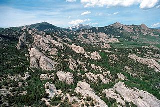
The Albion Mountains are a mountain range in the U.S. states of Idaho (~99%) and Utah (~1%), spanning Cassia County, Idaho and barely reaching into Box Elder County, Utah. The highest point in the range is Cache Peak at 10,339 feet (3,151 m), and the range is a part of the Basin and Range Province. Most of the mountains are part of the Albion Division of the Minidoka Ranger District of Sawtooth National Forest.
Cache Peak, at 10,339 feet (3,151 m) above sea level, is the highest peak in the Albion Mountains of Cassia County in Southern Idaho. Cache Peak is located in the central part of the range southeast of Oakley and north of Almo in the Albion Division of the Minidoka Ranger District of Sawtooth National Forest.

The Black Pine Mountains are a mountain range in the U.S. states of Idaho (~65%) and Utah (~35%), spanning Cassia County, Idaho and reaching into Box Elder County, Utah. The highest point in the range is known as Black Pine Mountains High Point, sometimes referred to as Black Peak, at 9,395 feet (2,864 m), and the range is a part of the Great Basin Divide and the Basin and Range Province. In Idaho, the mountains are part of the Black Pine Division of the Minidoka Ranger District of Sawtooth National Forest.
Mount Harrison, at 9,265 feet (2,824 m) is a peak in the northern Albion Mountains of Cassia County in southern Idaho. Mount Harrison is located in north of Cache Peak, south of Burley, northeast of Oakley, and west of Malta in the Albion Division of the Minidoka Ranger District of Sawtooth National Forest. Mount Harrison is in the watershed of tributaries of the Snake River, which itself is a tributary of the Columbia River. The peak can be reached via a paved road that runs all the way to its summit. Lake Cleveland is located in the basin north of the peak, and a small unnamed lake is located in the basin southeast of the peak.
Cymopterus evertii is a species of flowering plant in the carrot family known by the common names Evert's springparsley and Evert's waferparsnip. It is native to Utah and Wyoming in the United States.
Mount Independence is the second highest peak in the Albion Mountains of Idaho. The peak is located in Sawtooth National Forest and Cassia County. It is located about 1 mi (1.6 km) northwest of Cache Peak. The Independence Lakes are located in the basin to the east of the peak. Mount Independence supports one of the three populations of Cymopterus davisii, a plant that is endemic to the Albion Mountains. The Mount Independence population is considered a single population with Cache Peak. Mount Independence is 9,950 feet (3,030 m) above sea level.
Graham Peak is the fourth highest peak in the Albion Mountains of Idaho, at 8,867 feet (2,703 m) above sea level. The peak is located in the City of Rocks National Reserve and Cassia County less than 0.2 mi (0.32 km) south of the Sawtooth National Forest border. It is located 5.13 mi (8.26 km) south-southwest of Cache Peak. Forest road 707 leads directly to the summit. The peak contains the smallest of the three known populations of Cymopterus davisii, estimated at 500–1000 individuals.
Smoky Mountain, at 7,579 feet (2,310 m) above sea level is a peak in the Albion Mountains of Idaho. The peak is located in Cassia County about 0.35 mi (0.56 km) east of the border of City of Rocks National Reserve on land managed by the Bureau of Land Management. It is 4.7 mi (7.6 km) north of the Nevada border.
Thunder Mountain, at 7,455 feet (2,272 m) above sea level is a peak in the Albion Mountains of Idaho. The peak is located in Sawtooth National Forest and Cassia County. It is located about 2.7 mi (4.3 km) southeast of Cache Peak.

Mount Carter, at 10,590 feet (3,230 m) above sea level is the seventh highest peak in the Sawtooth Range of Idaho. The peak is located in the Sawtooth Wilderness of Sawtooth National Recreation Area on the border of Boise and Custer counties. The peak is located 0.32 mi (0.51 km) northwest of Mickey's Spire, its line parent, and 0.43 mi (0.69 km) west of Thompson Peak, the highest point in the range.
Mount Iowa, at 10,327 feet (3,148 m) above sea level is a peak in the Sawtooth Range of Idaho. The peak is located in the Sawtooth Wilderness of Sawtooth National Recreation Area in Custer County. The peak is located 0.65 mi (1.05 km) south-southeast of Horstmann Peak, its line parent. It is about 0.7 mi (1.1 km) north of Braxon Peak and 1.1 mi (1.8 km) west of Mount Heyburn.

Cymopterus glomeratus , now including Cymopterus acaulis, is a flowering plant. This plant is an aromatic plant of the family Apiaceae, a family of commonly known as the “celery, carrot, or parsley” family. The genus name comes from the Greek word, “Cyma” which means “wave” and “Pteron” which means “wing”, and combines to form the genus “Cymopterus”.

