Czerwieńsk

Last updated • 4 min readFrom Wikipedia, The Free Encyclopedia
Czerwieńsk
Kosciol w czerwiensku wisniowy.JPG
Gothic Revival Saint Adalbert church
POL Czerwiensk flag.svg
POL Czerwiensk COA.svg
Poland adm location map.svg
Red pog.svg
Czerwieńsk
Coordinates: 52°0′56″N15°24′18″E / 52.01556°N 15.40500°E / 52.01556; 15.40500
CountryFlag of Poland.svg  Poland
Voivodeship Lubusz
County Zielona Góra
Gmina Czerwieńsk
Established16th century
Town rights1690
Government
  MayorPiotr Iwanus
Area
  Total9.22 km2 (3.56 sq mi)
Population
 (31 December 2021 [1] )
  Total3,900
  Density420/km2 (1,100/sq mi)
Time zone UTC+1 (CET)
  Summer (DST) UTC+2 (CEST)
Postal code
66-016
Area code +48 68
Vehicle registration FZI
Climate Cfb
Website czerwiensk.pl

Czerwieńsk [ˈt͡ʂɛrvʲɛɲsk] (German : Rothenburg an der Oder) is a town in Zielona Góra County, Lubusz Voivodeship, in western Poland, with 3,900 inhabitants as of December 2021. [1] Czerwieńsk is a railroad junction, where the WrocławZielona GóraSzczecin connection meets the line to Poznań.

Contents

History

In the Middle Ages the area was settled by Slavs. [2] It formed part of Poland since its establishment in the 10th century and after the fragmentation of Poland it was part of various duchies ruled by the Polish Piast dynasty, the last being the Duchy of Głogów [2] until 1476. By 1538 the area was part of the Margraviate of Brandenburg. Until 1476 it was part of the historic region of Silesia.

Around 1550 the von Rothenburg family from Nettkowe (Nietków) built a small hunting manor some 5 kilometres from their ancestral home. [3] Soon a small village arose around the manor, [3] known as Neu Netkau - "New Netkau". The settlement was part of the region of Brandenburg's Neumark region and lay directly at the border with Silesia. While conveniently located at the crossing of important trading routes, the village's growth was halted by the devastating Thirty Years' War. [3] In 1654 a Lutheran church was built there. It served both local residents and the Protestant inhabitants of the nearby city of Zielona Góra, then part of the Bohemian (Czech) Kingdom ruled by the Roman Catholic House of Habsburg. [3] The first priest of the new church was Christoph Reiche.

On 24 January 1690 a new town of Rothenburg an der Oder ("Rothenburg on the Oder") was started right next to the village of Neu Netkau. The town received town rights from Frederick III, Elector of Brandenburg and grew rapidly in the 17th century, thanks to numerous draper shops founded there, mostly by Protestant refugees from Silesia. [3] In 1701 the town, as part of Brandenburg-Prussia, became part of the Kingdom of Prussia. [3] In 1707 priest Johannes Reiche, the descendant of Christoph Reiche, started the construction of a new, larger church. In 1736 Alexander Rudolf von Rothenburg was knighted by king Frederick William I of Prussia and received the title of a Count. His son, Friedrich Rudolf von Rothenburg, was among the closest friends of King Frederick the Great.

In 1788 the town was bought by Peter von Biron, the last Duke of Courland, a vassal state of the Polish–Lithuanian Commonwealth, who owned also the nearby town of Żagań. The town became the dowry of his daughter Pauline, who married into the Swabian line of the Hohenzollerns. The family retained control of large parts of the town and its surrounding even after the abolition of feudal ownership in Prussia.

In 1811 the first city plan was prepared. The 1816 administration reform of Prussia officially detached the town from the Province of Brandenburg and attached it to the Province of Silesia, reuniting it with Silesia after 340 years. In mid-19th century another Protestant church was built not far from the town square by a Protestant dissenter Martin Gottfried Julius Schöne. In 1870 the town was connected to the Guben-Zbąszyń railway and a train station was constructed. From 1871 to 1945 the town was part of Germany. In 1877 the old Protestant church was demolished and replaced with a new one, built in then-popular Gothic Revival style. In 1900 the town had 632 inhabitants. By 1908 the village of "Polnisch Nettkow" was incorporated into Rothenburg. The number of inhabitants grew and by 1933 reached 1430 people.

The town survived World War II relatively undamaged, but the manor was destroyed by the Red Army. In 1945, in the aftermath of the war, the town was granted to Poland in accordance to the Potsdam Agreement. [3] The German population of the area was expelled and the town was repopulated with Poles, mainly railwaymen from Greater Poland, refugees from eastern Polish areas annexed by the USSR (notably from Tarnopol and Monasterzyska), [3] and repatriates from the Soviet Union. [2] Renamed initially to Rozborg and then to its modern name, the town was stripped of the town rights, which it received again in 1969. [3] In 1949 a public library was founded in Czerwieńsk. [4]

Demographics

Historical population
YearPop.±%
19001,213    
19101,418+16.9%
19251,611+13.6%
19391,396−13.3%
YearPop.±%
19501,318−5.6%
19602,194+66.5%
20104,089+86.4%
Source: [5] [6]

International relations

Czerwieńsk is twinned with: [7]

Related Research Articles

<span class="mw-page-title-main">Zielona Góra</span> City in Lubusz Voivodeship, Poland

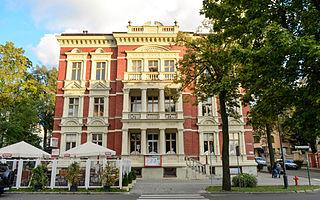
Zielona Góra is the largest city in Lubusz Voivodeship, located in western Poland, with 140,403 inhabitants (2021). The region is closely associated with vineyards and holds an annual Wine Fest. Zielona Góra is one of the two capital cities of Lubusz Voivodeship, hosting the province's elected assembly, while the seat of the centrally appointed governor is in the city of Gorzów Wielkopolski.

<span class="mw-page-title-main">Lubusz Voivodeship</span> Voivodeship of Poland

Lubusz Voivodeship is a voivodeship (province) in western Poland.

<span class="mw-page-title-main">Rotenburg an der Wümme</span> Town in Lower Saxony, Germany

Rotenburg an der Wümme is a town in Lower Saxony, Germany. It is the capital of the district of Rotenburg.

<span class="mw-page-title-main">Brzeg</span> Place in Opole Voivodeship, Poland

Brzeg is a town in southwestern Poland with 34,778 inhabitants and the capital of Brzeg County. It is situated in Silesia in the Opole Voivodeship on the left bank of the Oder river.

<span class="mw-page-title-main">Żagań</span> Place in Lubusz Voivodeship, Poland

Żagań is a town in western Poland, on the Bóbr river, with 25,731 inhabitants (2019). The town is the capital of Żagań County in the historic region of Silesia. Previously in the Zielona Góra Voivodeship (1975–1998), Żagań has been in the Lubusz Voivodeship since 1999.

<span class="mw-page-title-main">Krosno Odrzańskie</span> Place in Lubusz Voivodeship, Poland

Krosno Odrzańskie is a town in Lubusz Voivodeship in western Poland, on the east bank of Oder River, at the confluence with the Bóbr. With 11,319 inhabitants (2019) it is the capital of Krosno County.

<span class="mw-page-title-main">Babimost</span> Town in Lubusz Voivodeship, Poland

Babimost is a town in Zielona Góra County, Lubusz Voivodeship, western Poland. It is the administrative seat of Gmina Babimost. Babimost has an area of 3.65 square kilometres, and as of June 2022 it has a population of 3,848.

<span class="mw-page-title-main">Wschowa</span> Place in Lubusz Voivodeship, Poland

Wschowa is a town in the Lubusz Voivodeship in western Poland with 13,875 inhabitants (2019). It is the capital of Wschowa County and a significant tourist site containing many important historical monuments. It is part of the historic region of Greater Poland. Once an important royal city of Poland, due to its 18th-century history, it is sometimes called the "unofficial capital of Poland".

<span class="mw-page-title-main">Myślibórz</span> Place in West Pomeranian Voivodeship, Poland

Myślibórz is a town in northwestern Poland, in West Pomeranian Voivodeship. It is the capital of the Powiat of Myślibórz, with a population of 11,867.

<span class="mw-page-title-main">Lower Silesia</span> Historical region in Central Europe

Lower Silesia is a historical and geographical region mostly located in Poland with small portions in the Czech Republic and Germany. It is the western part of the region of Silesia. Its largest city is Wrocław.

<span class="mw-page-title-main">Bytom Odrzański</span> Place in Lubusz Voivodeship, Poland

Bytom Odrzański is a town on the Oder river in western Poland, in Nowa Sól County of Lubusz Voivodeship. As of December 2021, the town has a population of 4,191.

<span class="mw-page-title-main">Niemcza</span> Place in Lower Silesian Voivodeship, Poland

Niemcza is a town in Dzierżoniów County, Lower Silesian Voivodeship, in south-western Poland. It is the seat of the administrative district (gmina) called Gmina Niemcza.

<span class="mw-page-title-main">Sulechów</span> Place in Lubusz Voivodeship, Poland

Sulechów is a town located within the Zielona Góra County, in Lubusz Voivodeship, western Poland. It is the administrative seat of the Gmina Sulechów. Established in the Middle Ages, the town features many historical monuments significant to the Polish Lubusz region. The town limits cover 6.88 square kilometres (2.66 sq mi).

<span class="mw-page-title-main">Otyń</span> Place in Lubusz Voivodeship, Poland

Otyń is a town in western Poland, located in the Nowa Sól County, Lubusz Voivodeship. As of 2019 it has 1,615 inhabitants. It lies approximately 6 kilometres (4 mi) north of Nowa Sól and 18 km (11 mi) south-east of Zielona Góra.

<span class="mw-page-title-main">Cybinka</span> Place in Lubusz Voivodeship, Poland

Cybinka is a town in western Poland, in Słubice County, Lubusz Voivodeship. It is the administrative seat of the Gmina Cybinka.

<span class="mw-page-title-main">Ostroróg</span> Place in Greater Poland Voivodeship, Poland

Ostroróg is a town in Szamotuły County, Greater Poland Voivodeship, Poland, with 1,962 inhabitants (2010).

<span class="mw-page-title-main">Gmina Przewóz</span> Gmina in Lubusz Voivodeship, Poland

Gmina Przewóz is a rural gmina in Żary County, Lubusz Voivodeship, in western Poland, on the German border. Its seat is the village of Przewóz, which lies approximately 22 kilometres (14 mi) south-west of Żary and 64 km (40 mi) south-west of Zielona Góra.

<span class="mw-page-title-main">Rąpice</span> Village in Lubusz Voivodeship, Poland

Rąpice is a village in the administrative district of Gmina Cybinka, within Słubice County, Lubusz Voivodeship, in western Poland, close to the German border. It lies approximately 11 kilometres (7 mi) south-west of Cybinka, 29 km (18 mi) south-east of Słubice, 57 km (35 mi) west of Zielona Góra, and 77 km (48 mi) south-west of Gorzów Wielkopolski. It is located within the historic Lubusz Land.

<span class="mw-page-title-main">Sądów, Lubusz Voivodeship</span> Village in Lubusz Voivodeship, Poland

Sądów is a village in the administrative district of Gmina Cybinka, within Słubice County, Lubusz Voivodeship, in western Poland, close to the German border. It lies approximately 3 kilometres (2 mi) north-east of Cybinka, 24 km (15 mi) south-east of Słubice, 56 km (35 mi) north-west of Zielona Góra, and 64 km (40 mi) south-west of Gorzów Wielkopolski. It is located within the historic Lubusz Land.

<span class="mw-page-title-main">Nietków</span> Village in Lubusz Voivodeship, Poland

Nietków is a village in the administrative district of Gmina Czerwieńsk, within Zielona Góra County, Lubusz Voivodeship, in western Poland. It lies approximately 21 kilometres (13 mi) north of Czerwieńsk, 30 km (19 mi) north of Zielona Góra, and 61 km (38 mi) south of Gorzów Wielkopolski.

References

  1. 1 2 "Local Data Bank". Statistics Poland. Retrieved 2022-07-28. Data for territorial unit 0809034.
  2. 1 2 3 "Historia". Urząd Gminy i Miasta w Czerwieńsku (in Polish). Retrieved 10 October 2019.
  3. 1 2 3 4 5 6 7 8 9
    • Przemysław Góralczyk. "Historia miasta". czerwiensk.pl (in Polish). Urząd Gminy i Miasta w Czerwieńsku. Retrieved 2013-08-18.
  4. "Historia". Miejsko-Gminna Biblioteka Publiczna w Czerwieńsku (in Polish). Retrieved 10 October 2019.
  5. Dokumentacja Geograficzna (in Polish). Vol. 3/4. Warszawa: Instytut Geografii Polskiej Akademii Nauk. 1967. p. 8.
  6. Stan i struktura ludności oraz ruch naturalny w przekroju terytorialnym w 2010 r. (PDF) (in Polish). Warszawa: Główny Urząd Statystyczny. 2011. p. 61. Archived from the original (PDF) on 13 November 2011.
  7. "Miasta Partnerskie". czerwiensk.pl (in Polish). Czerwieńsk. Retrieved 2022-07-28.