Danbury Township, Ohio

Last updated

Danbury Township, Ottawa County, Ohio
Johnson's Island.JPG
Cemetery on Johnson's Island
Danbury Twp Ottawa OH.PNG
Location of Danbury Township in Ottawa County.
Coordinates: 41°31′56″N82°45′58″W / 41.53222°N 82.76611°W / 41.53222; -82.76611
Country United States
State Ohio
County Ottawa
Area
  Total56.5 sq mi (146.4 km2)
  Land18.2 sq mi (47.2 km2)
  Water38.3 sq mi (99.2 km2)
Elevation
[1]
640 ft (195 m)
Population
 (2020) [2]
  Total4,924
  Density270.5/sq mi (104.3/km2)
Time zone UTC-5 (Eastern (EST))
  Summer (DST) UTC-4 (EDT)
FIPS code 39-20058 [3]
GNIS feature ID1086760 [1]
Website Danbury Township

Danbury Township is one of the twelve townships of Ottawa County, Ohio, United States. The 2020 census found 4,924 people in the township.

Contents

Communities

Name and history

It is the only Danbury Township statewide. [4] This township is included in the region known as the Firelands and was originally a part of Huron County. [5] It was named for Danbury, Connecticut, the native home of a large share of the first settlers. [6]

Huron County was established by the Ohio General Assembly on February 7, 1809 and, at the time, comprised present-day Erie County (except for a small piece in the west); Huron County, Ruggles Township in Ashland County, Danbury Township, and part of Catawba Island Township. [7]

Johnson's Island, the location of a significant Prisoner-of-war camp during the Civil War, is located in Sandusky Bay just south of the Marblehead Peninsula. It is now a part of the village of Marblehead.

Geography

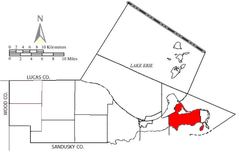
Located at the eastern point of the county at the end of the Marblehead Peninsula, it borders the following townships:

Demographics

The median age of males is 48.0 years of age. The median age of females is 48.6 years of age.

The median income for a household in the township was $55,578 in 2008. In 1999, the median income for a household in the township was $47,434. [8]

Government

The township is governed by a three-member board of trustees, who are elected in November of odd-numbered years to a four-year term beginning on the following January 1. Two are elected in the year after the presidential election and one is elected in the year before it. There is also an elected township fiscal officer, [9] who serves a four-year term beginning on April 1 of the year after the election, which is held in November of the year before the presidential election. Vacancies in the fiscal officership or on the board of trustees are filled by the remaining trustees.

Notable residents

Related Research Articles

<span class="mw-page-title-main">Erie County, Ohio</span> County in Ohio, United States

Erie County is a county in the northern portion of the U.S. state of Ohio. As of the 2020 census, the population was 75,622. Its county seat and largest city is Sandusky. The county is named for the Erie tribe, whose name was their word for "wildcat". It was formed in 1838 from the northern third of Huron County and a portion of Sandusky County.

<span class="mw-page-title-main">Erie Township, Michigan</span> Civil township in Michigan, United States

Erie Township is a civil township of Monroe County in the U.S. state of Michigan. The population was 4,299 at the 2020 census. Sharing a southern border with the city of Toledo, Ohio, about 45 miles (72 km) southwest of the city of Detroit, the township is one of the southernmost areas included in the Detroit–Warren–Ann Arbor Combined Statistical Area.

<span class="mw-page-title-main">Marblehead, Ohio</span> Village in Ohio, United States

Marblehead is a village in Ottawa County, Ohio, United States. The population was 865 at the 2020 census. It sits at the tip of the Marblehead Peninsula, which divides Lake Erie proper from Sandusky Bay. Marblehead is part of the area that is referred to regionally as Vacationland due to the large number of tourists who flock to the area in the summer months. It remains a popular vacation destination due to its lake frontage, ferry service to the Lake Erie Islands, quality sport fishery, the nearby Lakeside Chautauqua, and the Cedar Point amusement park. Marblehead is also home to the Lakeside Daisy State Nature Preserve, home to the only natural U.S. population of the Lakeside Daisy, an endangered species.

<span class="mw-page-title-main">Put-in-Bay, Ohio</span> Village in Ohio, United States

Put-in-Bay is a resort village located on South Bass Island in Put-in-Bay Township, Ottawa County, Ohio, United States, 85 miles (137 km) west of Cleveland and 35 miles (56 km) east of Toledo. The population was 154 at the 2020 census.

<span class="mw-page-title-main">Firelands</span>

The Firelands, or Sufferers' Lands, tract was located at the western end of the Connecticut Western Reserve in what is now the U.S. state of Ohio. It was legislatively established in 1792, as the "Sufferers' Lands", and later became named "Fire Lands" because the resale of the land was intended as financial restitution for residents of the Connecticut towns of Danbury, Fairfield, Greenwich, Groton, New Haven, New London, Norwalk, and Ridgefield. Their homes had been burned in 1779 and 1781 by British forces during the American Revolutionary War. However, most of the settlement of the area did not occur until after the War of 1812. "Fire Lands" was later spelled as one word: "Firelands."

<span class="mw-page-title-main">South Bass Island</span> Island in the United States of America

South Bass Island is a small island in western Lake Erie, and a part of Ottawa County, Ohio, United States. It is the southernmost of the three Bass Islands and located 3 miles (4.6 km) from the south shore of Lake Erie. It is the third largest island in the Lake Erie Islands, and is part of Put-in-Bay Township. In the bay of South Bass is Gibraltar Island, home to the Ohio State University's Stone Laboratory.

<span class="mw-page-title-main">Oxford Township, Erie County, Ohio</span> Township in Ohio, United States

Oxford Township is one of the nine townships of Erie County, Ohio, United States. It is part of the Sandusky, Ohio micropolitan statistical area and the Cleveland-Akron-Canton Combined Statistical Area. The 2020 census recorded 1,140 residents.

<span class="mw-page-title-main">Bay Township, Ohio</span> Township in Ohio, United States

Bay Township is one of the twelve townships of Ottawa County, Ohio, United States. The 2020 census found 1,142 people in the township.

<span class="mw-page-title-main">Catawba Island Township, Ohio</span> Township in Ohio, United States

Catawba Island Township is one of the twelve townships of Ottawa County, Ohio, United States. The 2020 census found 3,711 people in the township.

<span class="mw-page-title-main">Portage Township, Ottawa County, Ohio</span> Township in Ohio, United States

Portage Township is one of the twelve townships of Ottawa County, Ohio, United States. The 2020 census found 1,217 people in the township.

<span class="mw-page-title-main">Put-in-Bay Township, Ottawa County, Ohio</span> Township in Ohio, United States

Put-in-Bay Township is one of the twelve townships of Ottawa County, Ohio, United States. The 2020 census found 813 people in the township.

<span class="mw-page-title-main">Sandusky Bay</span> Bay on Lake Erie in Ohio

Sandusky Bay is a bay on Lake Erie in northern Ohio, formed at the mouth of the Sandusky River. It was identified as Lac Sandouské on a 1718 French map, with early variations recorded that suggest the name was derived from Native American languages. The Thomas A. Edison Memorial Bridge was constructed across it in the 20th century to connect highways in Erie and Ottawa counties.

<span class="mw-page-title-main">Huron Township, Erie County, Ohio</span> Township in Ohio, United States

Huron Township is one of the nine townships of Erie County, Ohio, United States. It is part of the Sandusky, Ohio metropolitan statistical area, with the city of Sandusky to the northwest. The township sits along the southwestern shoreline of Lake Erie, one of the Great Lakes. As of the 2020 census the population was 10,724.

<span class="mw-page-title-main">Margaretta Township, Erie County, Ohio</span> Township in Ohio, United States

Margaretta Township is one of the nine townships of Erie County, Ohio, United States. It is part of the Sandusky, Ohio metropolitan statistical area. As of the 2020 census the population was 5,640.

<span class="mw-page-title-main">Lyme Township, Huron County, Ohio</span> Township in Ohio, United States

Lyme Township is one of the nineteen townships of Huron County, Ohio, United States. As of the 2020 census the population of the township was 873.

<span class="mw-page-title-main">Ruggles Township, Ashland County, Ohio</span> Township in Ohio, United States

Ruggles Township is one of the fifteen townships of Ashland County, Ohio, United States. The population was 955 at the 2020 census.

Incorporated on April 17, 1886, at Marblehead, Ohio, the Lakeside and Marblehead Railroad (L&M) was a short standard gauge railroad that spanned about seven miles (11.3 km) in length. It extended from Marblehead through Lakeside to a connection with the Lake Shore and Michigan Southern Railway at Danbury. A common carrier, it carried both freight and passengers. It was abandoned as a common carrier railroad July 31, 1964, operated for the last time as a private industrial railroad in Summer 1978, and its tracks were removed in Fall 1997.

Fort Sandoské was a French military fort, built about 1750 on what is now called the Marblehead Peninsula on the northern side of Sandusky Bay in Ohio, near the traditional portage place from the bay to Lake Erie.

<span class="mw-page-title-main">Ottawa County, Ohio</span> County in Ohio, United States

Ottawa County is a county located in the northwestern part of the U.S. state of Ohio. As of the 2020 census, the population was 40,364. Its county seat is Port Clinton. The county is named either for the Ottawa (Odawa) Indigenous peoples who lived there, or for an Indigenous word meaning "trader".

<span class="mw-page-title-main">Vacationland (Ohio)</span> Tourist destination

The Vacationland region of Ohio—billed as such for being known primarily as a major summertime tourist destination—is the area that is generally considered to be in the north central part of the state, and along the western half of the Lake Erie shoreline around Sandusky Bay, specifically the counties of Erie, Huron, Ottawa, and Sandusky.

References

  1. 1 2 "US Board on Geographic Names". United States Geological Survey. October 25, 2007. Retrieved January 31, 2008.
  2. "Danbury township, Ottawa County, Ohio - Census Bureau Profile". United States Census Bureau. Retrieved August 3, 2023.
  3. "U.S. Census website". United States Census Bureau . Retrieved January 31, 2008.
  4. "Detailed map of Ohio" (PDF). United States Census Bureau. 2000. Retrieved February 16, 2007.
  5. Milan and the Milan Canal, by Charles E. Frohman, c.1976, pp. 26-28.
  6. Overman, William Daniel (1958). Ohio Town Names. Akron, OH: Atlantic Press. p. 36.[ permanent dead link ]
  7. Ohio Lands, A Short History, a publication of the Ohio Auditor of State, c. 1994, p. 10.
  8. "Danbury township, Ottawa County, Ohio (OH)". City-Data.com. Retrieved July 15, 2012.
  9. §503.24, §505.01, and §507.01 of the Ohio Revised Code. Accessed 4/30/2009.