
West Bengal is a state in the eastern portion of India. It is situated along the Bay of Bengal, along with a population of over 91 million inhabitants within an area of 88,752 km2 (34,267 sq mi). West Bengal is the fourth-most populous and thirteenth-largest state by area in India, as well as the eighth-most populous country subdivision of the world. As a part of the Bengal region of the Indian subcontinent, it borders Bangladesh in the east, and Nepal and Bhutan in the north. It also borders the Indian states of Odisha, Jharkhand, Bihar, Sikkim and Assam. The state capital is Kolkata, the third-largest metropolis, and seventh largest city by population in India. West Bengal includes the Darjeeling Himalayan hill region, the Ganges delta, the Rarh region, the coastal Sundarbans and the Bay of Bengal. The state's main ethnic group are the Bengalis, with the Bengali Hindus forming the demographic majority.

Darjeeling is a town and municipality in the northernmost region of the Indian state of West Bengal. Located in the Eastern Himalayas, it has an average elevation of 2,045 metres (6,709 ft). To the west of Darjeeling lies the easternmost province of Nepal, to the east the Kingdom of Bhutan, to the north the Indian state of Sikkim, and farther north the Tibet Autonomous Region region of China. Bangladesh lies to the south and southeast, and most of the state of West Bengal lies to the south and southwest, connected to the Darjeeling region by a narrow tract. Kangchenjunga, the world's third-highest mountain, rises to the north and is prominently visible on clear days.

Kalimpong is a town and the headquarters of an eponymous district in the Indian state of West Bengal. It is located at an average elevation of 1,250 metres (4,101 ft). The town is the headquarters of the Kalimpong district. The region comes under Gorkhaland Territorial Administration which is an autonomous governing body within the state of West Bengal. The Indian Army's 27 Mountain Division is located on the outskirts of the city.
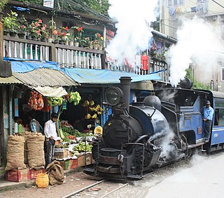
The Darjeeling Himalayan Railway, also known as the DHR or the Toy Train, is a 610 mm gauge railway that runs between New Jalpaiguri and Darjeeling in the Indian state of West Bengal. Built between 1879 and 1881, it is about 88 km (55 mi) long. It climbs from about 100 m (330 ft) above sea level at New Jalpaiguri to about 2,200 m (7,200 ft) at Darjeeling, using six zig zags and five loops to gain altitude. Six diesel locomotives handle most of the scheduled service, with daily tourist trains from Darjeeling to Ghum – India's highest railway station – and the steam-hauled Red Panda service from Darjeeling to Kurseong. Steam-enthusiast specials are hauled by vintage British-built B-Class steam locomotives. The railway's headquarters are at Kurseong.

Teesta River is a 414 km (257 mi) long river that rises in the Pauhunri Mountain of eastern Himalayas, flows through the Indian states of Sikkim and West Bengal through Rangpur, and enters the Bay of Bengal. It drains an area of 12,540 km2 (4,840 sq mi). In India, it flows through Mangan District, Gangtok District, Pakyong District, Kalimpong district, Darjeeling District, Jalpaiguri District, Cooch Behar districts and the cities of Rangpo, Jalpaiguri and Mekhliganj, Rangpur. It joins the Brahmaputra River at Phulchhari Upazila in Bangladesh. 305 km (190 mi) of the river lies in India and 109 km (68 mi) in Bangladesh. Teesta is the largest river of Sikkim and second largest river of West Bengal after the Ganges.

Darjeeling District is the northernmost district of the state of West Bengal in eastern India in the foothills of the Himalayas. The district is famous for its hill station and Darjeeling tea. Darjeeling is the district headquarters.
Transport in Darjeeling consists of the intra-city transport and the communication between the city and other locations in Darjeeling district. Darjeeling is a hill station in the Indian state of West Bengal and it is the headquarters of Darjeeling district situated in the Mahabharat Range at an average elevation of 2,134 m above sea level.
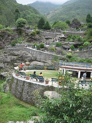
The Rock Garden at Chunnu Summer Falls and Ganga Maya Park are recently added tourist attractions in the hilly town of Darjeeling in the state of West Bengal, India. It is a showpiece meant to lure people to Darjeeling after political agitations disrupted tourism in the 1980s. There is another rock garden in Darjeeling known as Sir John Anderson Rock Garden, which is part of Lloyd's Botanical Garden.
Baikunthapur is a Terai forest region in the western part of the Dooars in West Bengal, India, south of the Himalayan foothills, between the Mahananda River to the west and Teesta River to the east. The main towns in the area are Siliguri and Jalpaiguri. The forests are partly in the Darjeeling district and partly in the Jalpaiguri district.
Bijanbari is a village in Darjeeling Pulbazar CD block in the Darjeeling Sadar subdivision of the Darjeeling district in West Bengal, India. It is a place of importance in Darjeeling district mainly because of the Block Divisional Office and a Hydel Power Plant.

Dr. Amit Mitra is an Indian economist and politician and the current Special Advisor to Chief Minister of West Bengal on Finance. Previously he was the Finance, Commerce & Industries Minister of the government of Indian state of West Bengal. He was the incumbent MLA in the West Bengal state assembly from the Khardaha state assembly constituency. Cited as a giant killer in the 2011 West Bengal state assembly election defeating Asim Dasgupta, the former West Bengal Finance Minister. Mitra previously served as the Secretary general of the Federation of Indian Chambers of Commerce and Industry (FICCI).
The Gorkhaland Territorial Administration is a semi-autonomous council for the Darjeeling and Kalimpong districts of West Bengal state in India. The GTA was formed in 2012 to replace the Darjeeling Gorkha Hill Council, which was formed in 1988 and administered the Darjeeling hills for 23 years.

The New Jalpaiguri–Alipurduar–Samuktala Road line is a railway line that connects New Jalpaiguri- Siliguri Junction with Alipurduar and Samuktala Road in the Indian state of West Bengal. This railway line passes through the beautiful Doars region, which includes Mahananda Wildlife Sanctuary, Dooars-Terai tea gardens, Sevoke Railway Bridge, River Teesta, River Jaldhaka, River Torsha, Gorumara National Park, Buxa Tiger Reserve, Jaldapara National Park, Chapramari Wildlife Sanctuary, Chilapata Forests, Tunnels, Hills, Valleys etc.

West Bengal is a state in the eastern region of India and is the nation's fourth-most populous. The state capital is Kolkata. The state encompasses two broad natural regions: the Gangetic Plain in the south and the sub-Himalayan and Himalayan area in the north. The tourism in West Bengal is maintained by WBTDCL, a state government owned enterprise.
Glenburn Tea Estate is a tea garden in the Rangli Rangliot CD block in the Darjeeling Sadar subdivision of the Darjeeling district in the Indian state of West Bengal.
Tukvar Tea Garden is a village in the Darjeeling Pulbazar CD block in the Darjeeling Sadar subdivision of the Darjeeling district in the state of West Bengal, India.
Singla Tea Garden is a village in the Darjeeling Pulbazar CD block in the Darjeeling Sadar subdivision of the Darjeeling district in the state of West Bengal, India.

The Aerial tramway, also known as Aerial lift or Aerial ropeway and cable car popularly known as ropeway in India, is a public transportation system where cabins, gondolas or open chairs are hauled above the ground with the help of cables. They are usually built in mountainous areas where it is difficult to build roads or railway.

