
Darjeeling is a city in the northernmost region of the Indian state of West Bengal. Located in the Eastern Himalayas, it has an average elevation of 2,045 metres (6,709 ft). To the west of Darjeeling lies the easternmost province of Nepal, to the east the Kingdom of Bhutan, to the north the Indian state of Sikkim, and farther north the Tibet Autonomous Region region of China. Bangladesh lies to the south and southeast, and most of the state of West Bengal lies to the south and southwest, connected to the Darjeeling region by a narrow tract. Kangchenjunga, the world's third-highest mountain, rises to the north and is prominently visible on clear days.

Kurseong is a town and a municipality in Darjeeling district in the Indian state of West Bengal. It is the headquarters of the Kurseong subdivision.

Ghum is a small hilly neighbourhood in the Darjeeling Himalayan hill region of West Bengal, India. It comes under ward number one of the Darjeeling Municipality. Ghum railway station of the Darjeeling Himalayan Railway is the highest railway station in India. It is situated at an altitude of 2,258 metres (7,407 ft). The place is the home of the Ghum Monastery and the Batasia Loop, a bend of the Darjeeling Himalayan Railway.

Observatory Hill is a hill near Chowrasta square, or The Mall as it is popularly known, in Darjeeling, West Bengal, India. Views of snow-clad peaks, including Mount Kanchenjunga, are visible from the Observatory Hill. The Bhutia Busty monastery was originally located here. Now the hill has the temple of Mahakal. Two important arteries of the town, Nehru Road and Bhanubhakta Sarani, meet at Chowrasta. Another school of thought suggests that the presence of the megalithic core to have been a place of worship of the Rongs, representing a sacred location of the classic Long Chok type.
Katapahar is a ridge in Darjeeling town in the Indian state of West Bengal. Katapahar and Jalapahar ridges meet at Observatory Hill.

Tonglu is one of the higher peaks of the Singalila Ridge and a small settlement inside the Singalila National Park in the Darjeeling subdivision, Darjeeling district in the state of West Bengal in India near the India - Nepal border. It is a roadside halt along the trekking route from Manebhanjan to Sandakphu. It has a number of guest houses and homestays for faring trekkers and tourists on their way to Sandakphu.

Peace Pagoda, Darjeeling or Darjeeling Peace Pagoda is one of the Peace Pagodas designed to provide a focus for people of all races and creeds to help unite them in their search for world peace. It is located in the town of Darjeeling in the Indian state of West Bengal. Like most of the other Peace Pagodas, it was built under the guidance of Nichidatsu Fujii (1885–1985), a Buddhist monk from Japan and founder of the Nipponzan-Myōhōji Buddhist Order.
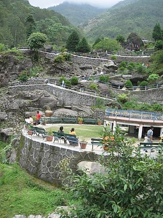
The Rock Garden at Chunnu Summer Falls and Ganga Maya Park are recently added tourist attractions in the hilly town of Darjeeling in the state of West Bengal, India. It is a showpiece meant to lure people to Darjeeling after political agitations disrupted tourism in the 1980s. There is another rock garden in Darjeeling known as Sir John Anderson Rock Garden, which is part of Lloyd's Botanical Garden.
Bijanbari is a small town in Darjeeling district with Darjeeling Pulbazar CD block being the headquarters of the Darjeeling Sadar subdivision in West Bengal, India. It is a place of importance in Darjeeling district mainly because of the Block Divisional Office and a Hydel Power Plant. It is a valley land with number of homestays and it takes 1.5 hours to reach from the main town Darjeeling.
Rimbick is a village in the Darjeeling Pulbazar CD block in the Darjeeling Sadar subdivision of the Darjeeling district in West Bengal, India.

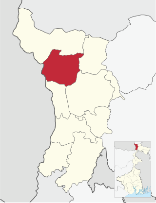
Darjeeling Pulbazar is a community development block that forms an administrative division in the Darjeeling Sadar subdivision of the Darjeeling district in the Indian state of West Bengal.
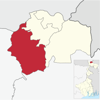
Jorebunglow Sukhiapokhri is a community development block that forms an administrative division in the Darjeeling Sadar subdivision of the Darjeeling district in the Indian state of West Bengal.

Rangli Rangliot is a community development block that forms an administrative division in the Darjeeling Sadar subdivision of the Darjeeling district in the Indian state of West Bengal.
Kalimpong I is a community development block that forms an administrative division in the Kalimpong subdivision of the Kalimpong district in the Indian state of West Bengal.

Chowrasta "Intersection" lit. where four roads meet) is a historical public square in the Victorian era hill resort town of Darjeeling in the state of West Bengal, India. Located in the heart of the town it was the fashionable place of assembly for residents and visitors in the 18th century. Chowrasta is situated on the ridge of the Darjeeling hill range and is now a center of tourist attraction and a popular spot for the residents to assemble.
Ging Tea Garden is a census town in the Darjeeling Pulbazar CD block in the Darjeeling Sadar subdivision of the Darjeeling district in the state of West Bengal, India.
Chongtong Tea Garden is a census town in the Darjeeling Pulbazar CD block in the Darjeeling Sadar subdivision of the Darjeeling district in the state of West Bengal, India.
Singtam Tea Garden is a census town in the Darjeeling Pulbazar CD block in the Darjeeling Sadar subdivision of the Darjeeling district in the state of West Bengal, India.
Badamtam Tea Garden is a census town and a gram panchayat in the Darjeeling Pulbazar CD block in the Darjeeling Sadar subdivision of the Darjeeling district in the state of West Bengal, India.
Singla Tea Garden is a village in the Darjeeling Pulbazar CD block in the Darjeeling Sadar subdivision of the Darjeeling district in the state of West Bengal, India.