
Ben Nevis is the highest mountain in Scotland, the United Kingdom, and the British Isles. Ben Nevis stands at the western end of the Grampian Mountains in the Highland region of Lochaber, close to the town of Fort William. The mountain's name can translate to either "cloudy mountain" or "venomous mountain".

Darjeeling is a city in the northernmost region of the Indian state of West Bengal. Located in the Eastern Himalayas, it has an average elevation of 2,045 metres (6,709 ft). To the west of Darjeeling lies the easternmost province of Nepal, to the east the Kingdom of Bhutan, to the north the Indian state of Sikkim, and farther north the Tibet Autonomous Region region of China. Bangladesh lies to the south and southeast, and most of the state of West Bengal lies to the south and southwest, connected to the Darjeeling region by a narrow tract. Kangchenjunga, the world's third-highest mountain, rises to the north and is prominently visible on clear days.

Richmond Hill is a city in south-central York Region, Ontario, Canada. Part of the Greater Toronto Area, it is the York Region's third most populous municipality and the 27th most populous municipality in Canada. Richmond Hill is situated between the cities of Markham and Vaughan, north of Thornhill, and south of Aurora.

Kalimpong is a town and the headquarters of an eponymous district in the Indian state of West Bengal. It is located at an average elevation of 1,250 metres (4,101 ft). The town is the headquarters of the Kalimpong district. The region comes under Gorkhaland Territorial Administration which is an autonomous governing body within the state of West Bengal. The Indian Army's 27 Mountain Division is located on the outskirts of the city.
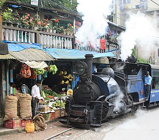
The Darjeeling Himalayan Railway, also known as the DHR or the Toy Train, is a 610 mm gauge railway that runs between New Jalpaiguri and Darjeeling in the Indian state of West Bengal. Built between 1879 and 1881, it is about 88 km (55 mi) long. It climbs from about 100 m (330 ft) above sea level at New Jalpaiguri to about 2,200 m (7,200 ft) at Darjeeling, using six zig zags and three loops to gain altitude. Ghum station is situated at an altitude of 2,258 metres (7,407 ft). Six diesel locomotives handle most of the scheduled service, with daily tourist trains from Darjeeling to Ghum – India's highest railway station – and the steam-hauled Red Panda service from Darjeeling to Kurseong. Steam-enthusiast specials are hauled by vintage British-built B-Class steam locomotives. The railway's headquarters are at Kurseong.

Darjeeling District is the northernmost district of the state of West Bengal in eastern India in the foothills of the Himalayas. The district is famous for its hill station and Darjeeling tea. Darjeeling is the district headquarters. Kurseong, Siliguri and Mirik, three major towns in the district, are the subdivisional headquarters of the district. Kalimpong was one of the subdivisions but on 14 February 2017, it officially became a separate Kalimpong district.

Ghum is a small hilly neighbourhood in the Darjeeling Himalayan hill region of West Bengal, India. It comes under ward number one of the Darjeeling Municipality. Ghum railway station of the Darjeeling Himalayan Railway is the highest railway station in India. It is situated at an altitude of 2,258 metres (7,407 ft). The place is the home of the Ghum Monastery and the Batasia Loop, a bend of the Darjeeling Himalayan Railway.

Observatory Hill is a hill near Chowrasta square, or The Mall as it is popularly known, in Darjeeling, West Bengal, India. Views of snow-clad peaks, including Mount Kanchenjunga, are visible from the Observatory Hill. The Bhutia Busty monastery was originally located here. Now the hill has the temple of Mahakal. Two important arteries of the town, Nehru Road and Bhanubhakta Sarani, meet at Chowrasta. Another school of thought suggests that the presence of the megalithic core to have been a place of worship of the Rongs, representing a sacred location of the classic Long Chok type.
Jalapahar is a ridge as well as a locality in the hilly town of Darjeeling in the Indian state of West Bengal. There was a British military camp in this locality in the Raj days. This ridge meets Katapahar ridge at Observatory Hill. St. Paul's School, one of the oldest public schools, is located here. Jalapahar gives a breath-taking view of Darjeeling town nestling under the majestic peak of Kanchenjanga.

Peace Pagoda, Darjeeling or Darjeeling Peace Pagoda is one of the Peace Pagodas designed to provide a focus for people of all races and creeds to help unite them in their search for world peace. It is located in the town of Darjeeling in the Indian state of West Bengal. Like most of the other Peace Pagodas, it was built under the guidance of Nichidatsu Fujii (1885–1985), a Buddhist monk from Japan and founder of the Nipponzan-Myōhōji Buddhist Order.

The Darjeeling Ropeway is a ropeway in the town of Darjeeling in the Indian state of West Bengal. The 5 km long ropeway( i.e. 2.5 km each way) is a tourist destination in the town. It consists of sixteen cars and plies between the "North Point" in the town of Darjeeling and Singla on the banks of the Ramman river. The journey on the ropeway offers views of the hills and the valleys around Darjeeling.
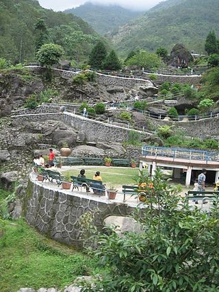
The Rock Garden at Chunnu Summer Falls and Ganga Maya Park are recently added tourist attractions in the hilly town of Darjeeling in the state of West Bengal, India. It is a showpiece meant to lure people to Darjeeling after political agitations disrupted tourism in the 1980s. There is another rock garden in Darjeeling known as Sir John Anderson Rock Garden, which is part of Lloyd's Botanical Garden.

Darjeeling Pulbazar is a community development block that forms an administrative division in the Darjeeling Sadar subdivision of the Darjeeling district in the Indian state of West Bengal.
Jorebunglow Sukhiapokhri is a community development block that forms an administrative division in the Darjeeling Sadar subdivision of the Darjeeling district in the Indian state of West Bengal.

Rangli Rangliot is a community development block that forms an administrative division in the Darjeeling Sadar subdivision of the Darjeeling district in the Indian state of West Bengal.
Kalimpong I is a community development block that forms an administrative division in the Kalimpong subdivision of the Kalimpong district in the Indian state of West Bengal.

Kalimpong II was a community development block that forms an administrative division in the Kalimpong subdivision of the Kalimpong district in the Indian state of West Bengal.

Gorubathan is a community development block that forms an administrative division in the Kalimpong subdivision of the Kalimpong district in the Indian state of West Bengal.

The Mahakal Temple or Mahakal Mandir. Translation: The master of Kaal[time]) is a sacred Hindu temple located in Darjeeling, West Bengal, India, dedicated to the Hindu god Shiva, the third god in the Hindu triumvirate. The temple was built in 1782 by Lama Dorjey Rinzing and is perched atop the Observatory Hill and is an amalgamation of Hindu and Buddhist religions. It is a religious site where both religions coexist harmoniously.

Chowrasta "Intersection" lit. where four roads meet) is a historical public square in the Victorian era hill resort town of Darjeeling in the state of West Bengal, India. Located in the heart of the town it was the fashionable place of assembly for residents and visitors in the 18th century. Chowrasta is situated on the ridge of the Darjeeling hill range and is now a center of tourist attraction and a popular spot for the residents to assemble.