Demographics of Darjeeling

Last updated

Darjeeling district's population today is constituted largely of the descendants of the indigenous and immigrant labourers that were employed in the original development of the town. Although their common language, the Nepali language, has been given official recognition at the state and federal levels in India, the recognition has brought little economic progress to the region, nor significant political autonomy. A culture of both pride and dependence has evolved in the tea plantations where jobs have levelled off but housing can be inherited by a worker within the family. The population of Darjeeling meanwhile has grown substantially over the years. Many young locals, educated in government schools, have taken to migrating out for the lack of employment matching their skills. Like out-migrants from other regions of northeastern India, they have been subjected to discrimination and racism in some Indian cities.

Contents

History

Although Darjeeling had its origins in the colonial period as a summer resort, it began to acquire characteristics of an "administrative" town in independent India after being made the headquarters of Darjeeling district in 1947. [1] During the period 1961–2011, the population of Darjeeling increased at an accelerated rate (Figure 9), as did an "aspirational middle class" comprising families of professionals in the administration, and in retail and service industries. [1] Indian Gorkha is a term that denotes the Nepali-speaking people of northeastern India as distinct from the Nepali-speaking inhabitants of Nepal. [2] According to a 2014 study, although the demand for labour in the tea estates surrounding Darjeeling had stayed roughly constant since 1910, the population of Nepali-speaking workers and their families in the tea estates had grown throughout. [3] As the excess population migrated up to Darjeeling in search of jobs and housing, they were propelled by the Gorkhaland agitation in the 1980s, which also had the effect of making many non-Gorkha families leave their homes in Darjeeling. [3]

The town of Darjeeling has seen fluctuation in the growth of its population in the last century. However, growth in population has been more rapid from the 1970s onwards, exceeding the growth rates at the district level. The growth rate has touched the sky height of about 45% in the 1990s and thus is far above the national, state, and district average. The colonial town of Darjeeling was designed for a mere population of 10,000. So the population spurt has made the town more prone to the environmental problems in recent decades as the region is geologically relatively new with hosts of environmental problems and hence unstable in nature. [4] Environmental degradation has adversely affected Darjeeling's appeal for tourists. The town as a district headquarters acts as the center of all types of economic activity, which attracts the rural folks of the district to migrate to the town for better opportunity. Besides, the pleasant climate of the town compels the people from the surrounding states to migrate and settle permanently in the region.

2011 census

Historical populations [4]
Census
year
PopulationGrowth (%)

190117,000
191119,00012.3
192122,00017.1
193121,000-4.8
194127,00028.5
195134,00023.4
196141,00021.0
197143,0005.5
198158,00034.4
199171,00024.1
2001103,00044.6

According to provisional results of 2011 census, Darjeeling Urban Agglomeration had a population of 132,016, out of which 65,839 were males and 66,177 were females. The sex ratio was 1005 females per 1,000 males. The 0–6 years population was 7,382. Effective literacy rate for the population older than 6 years was 93.2 per cent. [5]

The population of the Darjeeling municipal area in the Indian decennial census of 2011 (the last for which there is processed data [6] ) was 118,805 individuals; of those, 59,618 were females and 59,187 were males, yielding a gender ratio of 1007 females for every 1000 males. [7] The population density of the Darjeeling municipality was 15,990 individuals per 1 square kilometre (0.39 sq mi). [7] The literacy rate of Darjeeling town was 93.9%; the female literacy rate was 91.3% and the male was 96.4%. [7] Among groups whose historical disadvantages have been recognized by the Constitution of India and designated for amelioration in subsequent commissions and programmes of the Government of India and state governments, the scheduled tribes of Darjeeling town constituted approximately 22.4% of the population, and the scheduled castes 7.7%. [7] The work participation rate was 34.4%. [7] The population that lived in slums was 25,026 individuals (21.1% of the population). [7]

2001 census

As per the 2001 census, the Darjeeling urban agglomeration (which includes Pattabong Tea Garden), with an area of 12.77 km², has a population of 109,163. Also, the town has an additional average diurnal floating population of 20,500–30,000, mainly consisting of tourists and visitors. [4] The population density is 8548 per km². The sex ratio is 1017 females per 1000 males [8]  which is higher than the national average. The town houses about 31% of its population in the slums. This is the result of the unprecedented urban growth due to the unsustainable migration in the area (mainly of daily wage earners) for better opportunity. [4]

Ethnic groups and languages

Religion in Darjeeling municipality (2011) [9]
Hinduism
66.51%
Buddhism
23.91%
Christianity
5.13%
Islam
3.94%
Other or not stated
0.51%

In the 2011 census, [6] between them they practiced Hinduism (66.51%), Buddhism (23.9%), Christianity (5.1%) and Islam (3.9%). [7] The Lepchas were considered the main indigenous community of the region, their original religion being a form of animism. [10] The Gorkhali community was a complex mix of numerous castes and ethnic groups, with the roots of many in tribal and animist traditions. [10] The accelerated growth of the town's population and the tightly packed living conditions in which different ethnicities mixed had created syncretic cultures in Darjeeling which had evolved away from their historical roots. [10]

Languages of Darjeeling municipality (2011) [11]

   Nepali (82.32%)
   Hindi (7.69%)
   Tibetan (2.78%)
   Bhojpuri (1.60%)
   Urdu (1.54%)
   Bengali (0.94%)
  Others (3.13%)

The majority of the populace are ethnic Gorkhali. Indigenous ethnic groups include the Lepchas and Bhutias. The Kiratis are Rais, Limbus, Yakkhas Sunuwars, Dhimals and The Indian Gorkha ethnic groups include Chhetri, Thakuri, Bahun, Jogi/Sanyasi, Magar, Gurung, Kami, Damai, Tamang, Newar, Thami, Sherpa, Yalmo. Other communities are the Bengalis, Marwaris, Anglo-Indians, Han Chinese, Biharis and Tibetans. Nepali is the lingua franca of Darjeeling, and is spoken as a first language by all Gorkhas. [12] others are Tibetan, Hindi, English and Bengali. Previously languages such as Rai, Limbu, Lepcha and Magar were widely spoken among many of the Gorkhas, but since the 1960s speakers of these languages have shifted rapidly to Nepali and lost their original tongues.

As of 2016, the population of the town of Darjeeling was predominantly Gorkha or Nepali speaking. There were also smaller numbers of Lepchas, Bhutias, Tibetans, Bengalis, Marwaris and Biharis. [10]

Migration

Although seasonal migration has long been a local feature, especially among the lower-income groups, substantial migration among middle-class youth is a 21st-century occurrence. [13] Many educated young people in Darjeeling have begun to migrate out because the growth of jobs in the area has not kept pace with the numbers of people with tertiary degrees. [13] Favoured destinations fall into three groups: neighbouring Gangtok in Sikkim, and Siliguri in North Bengal at the base of the Darjeeling hills; the large bustling cities of Delhi, Kolkata, Bangalore, and Mumbai; and Kathmandu, the capital of Nepal, where there is a linguistic culture in which they feel comfortable. [14] The migrants are generally distinguishable by levels of education and access to economic privilege: those migrating to pursue higher education and professional careers, among which are engineering and journalism; and those looking for immediate employment, the common choices of which include call centres, beauty parlors, and dumpling stands. [14] Both groups of migrants have experienced racism and economic and social discrimination in India's big cities, caused by their distinctive, more East Asian, physical appearance. [15]

Related Research Articles

<span class="mw-page-title-main">Darjeeling</span> Town in West Bengal, India

Darjeeling is a town and municipality in the northernmost region of the Indian state of West Bengal. Located in the Eastern Himalayas, it has an average elevation of 2,045 metres (6,709 ft). To the west of Darjeeling lies the easternmost province of Nepal, to the east the Kingdom of Bhutan, to the north the Indian state of Sikkim, and farther north the Tibet Autonomous Region region of China. Bangladesh lies to the south and southeast, and most of the state of West Bengal lies to the south and southwest, connected to the Darjeeling region by a narrow tract. Kangchenjunga, the world's third-highest mountain, rises to the north and is prominently visible on clear days.

<span class="mw-page-title-main">Kalimpong</span> Town in West Bengal, India

Kalimpong is a town and the headquarters of an eponymous district in the Indian state of West Bengal. It is located at an average elevation of 1,250 metres (4,101 ft). The town is the headquarters of the Kalimpong district. The region comes under Gorkhaland Territorial Administration which is an autonomous governing body within the state of West Bengal. The Indian Army's 27 Mountain Division is located on the outskirts of the city.

<span class="mw-page-title-main">Gorkha National Liberation Front</span> Political party in India

Gorkha National Liberation Front (GNLF) is a political party in the Darjeeling District of West Bengal, India. It was formed in 1980 by Subhash Ghisingh with the objective of demanding a Gorkhaland state within India.

<span class="mw-page-title-main">Namchi district</span> District in Sikkim, India

Namchi District is a district of the Indian state of Sikkim. Its headquarters is at Namchi.

<span class="mw-page-title-main">Darjeeling district</span> District of West Bengal, India

Darjeeling District is the northernmost district of the state of West Bengal in eastern India in the foothills of the Himalayas. The district is famous for its hill station and Darjeeling tea. Darjeeling is the district headquarters.

<span class="mw-page-title-main">Darjeeling tea</span> Type of black tea from India

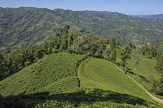
Darjeeling tea is a tea made from Camellia sinensis var. sinensis that is grown and processed in Darjeeling district or Kalimpong district in West Bengal, India. Since 2004, the term Darjeeling tea has been a registered geographical indication referring to products produced on certain estates within Darjeeling and Kalimpong. The tea leaves are processed as black tea, though some estates have expanded their product offerings to include leaves suitable for making green, white, and oolong teas.

<span class="mw-page-title-main">Ilam District</span> District in Koshi Province, Nepal

Ilam district is one of 14 districts of Koshi Province of eastern Nepal. It is a Hill district and covers 1,703 km2 (658 sq mi). The 2011 census counted 290,254 population. The municipality of Ilam is the district headquarters and is about 600 km (370 mi) from Kathmandu.

<span class="mw-page-title-main">Kurseong</span> Town in West Bengal, India

Kurseong is a town and a municipality in Darjeeling district in the Indian state of West Bengal. It is the headquarters of the Kurseong subdivision.

<span class="mw-page-title-main">Mirik</span> Town in West Bengal, India

Mirik is a small town and a Notified Area of Darjeeling district in the state of West Bengal, India. It is the headquarters of the Mirik subdivision. The name Mirik comes from the Lepcha words Mir-Yok meaning "place burnt by fire".

<span class="mw-page-title-main">History of Darjeeling</span>

The History of Darjeeling covers the history of Darjeeling town and its adjoining hill areas belonging to Sikkim, but eventually part of British India so now in the Indian state of West Bengal, which is intertwined with the history of Nepal, Sikkim, Bhutan, Bengal and Great Britain. Part of the state of Sikkim, Darjeeling became part of an important buffer state between Nepal and Bhutan. The British, using the area as a sanitorium, found that the climate provided excellent tea-cultivating conditions and soon began to grow tea on the hills of Darjeeling. Darjeeling tea remains a world-renowned export from Darjeeling.

Pokhriabong is a village in the Jorebunglow Sukhiapokri CD block in the Darjeeling Sadar subdivision of the Darjeeling district in West Bengal, India.

<span class="mw-page-title-main">Sukhia Pokhri</span> Census Town in West Bengal, India

Sukhia Pokhri is a census town in the Jorebunglow Sukhiapokhri CD block in the Darjeeling Sadar subdivision of the Darjeeling district in the indian state of West Bengal. It is located 11 km from Ghum on the way to Mirik.

<span class="mw-page-title-main">Culture of Darjeeling</span> Overview of the culture of Darjeeling, (India)

The culture of Darjeeling, India, is diverse and has a regional distinctness.

Gorubathan is a village in the Gorubathan CD block in the Kalimpong Sadar subdivision of the Kalimpong district in the Indian state of West Bengal.

<span class="mw-page-title-main">Soureni</span> Village in West Bengal, India

Soureni is a village in the Mirik CD block in the Mirik subdivision of the Darjeeling district, in West Bengal, India.

<span class="mw-page-title-main">Indian Gorkha</span> Ethnolinguistic group in India

Indian Gorkhas, also known as Nepali Indians, are Nepali language-speaking citizens in the Indian Republic. The modern term "Indian Gorkha" is used to differentiate the ethnic Gorkhas from Nepalis.

<span class="mw-page-title-main">Kalimpong district</span> District in West Bengal, India

Kalimpong district is a district in the state of West Bengal, India. Originally known as Dalingkot tehsil, the region was alternatively under the control of Sikkim and Bhutan. In 1865, it was annexed from Bhutan by British India under the Treaty of Sinchula, and administered as a subdivision of the Darjeeling district from 1916 to 2017. In 2017, it was carved out as a separate district to become the 21st district of West Bengal.

Chongtong Tea Garden is a census town in the Darjeeling Pulbazar CD block in the Darjeeling Sadar subdivision of the Darjeeling district in the state of West Bengal, India.

Soom Tea Garden is a village in the Darjeeling Pulbazar CD block in the Darjeeling Sadar subdivision of the Darjeeling district in the state of West Bengal, India.

Dhajea Tea Garden is a village in the Jorebunglow Sukhiapokhri CD block in the Darjeeling Sadar subdivision of the Darjeeling district in the state of West Bengal, India.

References

  1. 1 2 Mondal & Roychowdhury 2018, p. 367.
  2. Middleton & Shneiderman 2018, pp. 158–159: "Early Nepali literary stalwarts like Parasmani Pradhan used both the terms Nepali and Gorkha interchangeably... Thus early associations of the Nepalis in India... used the word "Gorkha" to denote Nepalis of Indian origin".
  3. 1 2 Besky 2014, p. 84.
  4. 1 2 3 4 Khawas, Vimal (2003). "Urban Management in Darjeeling Himalaya: A Case Study of Darjeeling Municipality". The Mountain Forum. Archived from the original on 20 October 2004. Retrieved 1 May 2006.
  5. "Urban agglomerations/cities having population 1 lakh and above" (PDF). Provisional population totals, census of India 2011. The registrar general & census commissioner, India. Retrieved 12 February 2012.
  6. 1 2 Mandal, Dilip (13 May 2022). "Decade without data – Why India is delaying Census when US, UK, China went ahead during Covid". The Print. Retrieved 30 July 2022. In all likelihood, India will not have its decadal census any time soon. The logjam is such that it may lead to a situation where a whole decade goes by without any official data on India and Indians. 2021 was a Census year and the Narendra Modi government decided not to conduct it due to the Covid pandemic. Now, Home Minister Amit Shah has said that the next Census will be an e-survey and carried out by 2024—it will be India's first 'digital Census'.
  7. 1 2 3 4 5 6 7 Mondal & Roychowdhury 2018, p. 368.
  8. Directorate of Census Operations, West Bengal (2003). "Table-4 Population, Decadal Growth Rate, Density and General Sex Ratio by Residence and Sex, West Bengal/ District/ Sub District, 1991 and 2001". Archived from the original on 27 August 2005. Retrieved 30 April 2006.
  9. "Table C-01 Population by Religion: West Bengal". censusindia.gov.in. Registrar General and Census Commissioner of India. 2011.
  10. 1 2 3 4 Lama & Rai 2016, p. 90.
  11. "Table C-16 Population by Mother Tongue: West Bengal". www.censusindia.gov.in. Registrar General and Census Commissioner of India.
  12. Middleton & Shneiderman 2018, Note on Language.
  13. 1 2 Brown, Scrase & Ganguly-Scrase 2017, p. 535.
  14. 1 2 Brown, Scrase & Ganguly-Scrase 2017, pp. 535–536.
  15. Brown, Scrase & Ganguly-Scrase 2017, pp. 535–538.

Works cited

Further reading