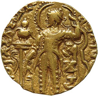
Samudragupta (Gupta script: Sa-mu-dra-gu-pta, r. c. was the second emperor of the Gupta Empire of Ancient India, and one of the greatest rulers in Indian history. As a son of the Gupta emperor Chandragupta I and the Lichchhavi princess Kumaradevi, he greatly expanded his dynasty's political power.

Kamarupi Prakrit is the postulated Middle Indo-Aryan (MIA) Prakrit language used in ancient Kamarupa. This language is the historical ancestor of the Kamatapuri lects and the modern Assamese language; and can be dated prior to 1250 CE, when the proto-Kamta language, the parent of the Kamatapuri lects, began to develop. Though not substantially proven, the existence of the language that predated the Kamatapuri lects and modern Assamese is widely believed.
Kamarupa, an early state during the Classical period on the Indian subcontinent, was the first historical kingdom of Assam. Pragjoytisha region also refers to present day Sylhet region including west of Assam.

The history of Assam is the history of a confluence of people from the east, west, south and the north; the confluence of the Tibeto-Burman (Sino-Tibetan), Indo-Aryan and Austroasiatic cultures. Although invaded over the centuries, it was never a vassal or a colony to an external power until the third Burmese invasion in 1821, and, subsequently, the British ingress into Assam in 1824 during the First Anglo-Burmese War.
The Varman dynasty (350-650) was the first historical dynasty of the Kamarupa kingdom. It was established by Pushyavarman, a contemporary of Samudragupta. The earlier Varmans were subordinates of the Gupta Empire, but as the power of the Guptas waned, Mahendravarman (470-494) performed two horse sacrifices and the status of Kamarupa as independent state remained umimpaired. According to the Allahabad Prasasti, the ruler of Kamarupa was a frontier ruler (Pratyanta-nrpatis) of the great Gupta emperor.
The Mlechchha dynasty ruled Kamarupa from their capital at Harruppesvar in present-day Tezpur, Assam, after the fall of the Varman dynasty. According to historical records, there were twenty one rulers in this dynasty, but the line is obscure and names of some intervening rulers are not known.
Pragjyotisha was an ancient kingdom that later came to be associated with the historical Kamarupa.
Though the precise Etymology of Assam, a state in India is unclear—there is general agreement that it is related to the Ahom people. Whatever the source of the English name, Assam is itself an anglicization.

Lower Assam is a region situated in Western Brahmaputra Valley encompassing undivided Kamrup and Goalpara regions.

Kamrupi Brahmins, also known as Kamarupi Brahmana and Kamrupi Bamon; are those brahmins who claimed their descent from the Kanauji immigrant brahmins and Maithili brahmins whom settled in Kamarupa(present day Assam). They brought with them different Hindu epics and became the torch-bearers of Aryan culture in the region.
People speaking Indo-Aryan languages first migrated to Assam in approximately the fifth century BCE. They came from the Gangetic Plains into a region already inhabited by people who spoke Austroasiatic and Tibeto-Burman languages.

Kalyanavarman ruled Kamarupa from the Varman dynasty for the period of 422-446 A.D. He was the son of Kamrupi king Balavarman and queen Ratnavati. He married Gandharvavati and had a successor to throne named Ganapativarman.

Pragjyotishpura, now deemed to be a region within modern Guwahati, was an ancient city and capital of the medieval Kamarupa Kingdom under Varman dynasty. The earliest mention from local sources come from the 7th century.

Kamarupa was most a powerful and formidable kingdom in Northeast India ruled by three dynasties from their capitals in Pragjyotishpura, Haruppeshwara and Durjaya. From these three capitals, its culture and influence spread over the entire region.
Kamrupi dialects are a group of regional dialects of Assamese, spoken in the Kamrup region. It formerly enjoyed prestige status. It is one of two western dialect groups of the Assamese language, the other being Goalpariya. Kamrupi is heterogeneous with three subdialects— Barpetia dialect, Nalbariya dialect and Palasbaria dialect.
Avantivarman is believed to be the last king of the Varman dynasty of Kamarupa in present-day North-East India.

Kamrup is the modern region situated between two rivers, the Manas and the Barnady in Western Assam, with the same territorial extent as the Colonial and post-Colonial "Undivided Kamrup district". It was the capital region of two of the three dynasties of Kamarupa and Guwahati, the current political center of Assam, is situated here. It is characterized by its cultural artifacts.

Kamarupi script was the script used in ancient Kamarupa from as early as 5th century to 13th century, from which the modern Assamese script eventually evolved. In the development of the Assamese script, this phase was followed by the medieval and then by the modern Assamese scripts.

Kamapitha is one of the four Kamarupa Pithas, the geographical divisions of ancient Kamarupa. Dineshchandra Sircar points out that these divisions are not found in the Kamarupa inscriptions and that they might be fabrications from late medieval sources, such as 16th-century work Yogini Tantra gives the boundaries of Kamapitha and other three pithas, the same work which gives boundaries of ancient Kamrup kingdom as well. The eastern border of Kamarupa was the temple of the goddess Tamreshvari near present-day Sadiya

Hojai District is a district in Assam, India. It was formed on 15 August 2015. The headquarters of the District is situated at Sankardev Nagar, which is about 8 km away from Hojai town. Hojai District was formed from three tehsils of Nagaon District, namely Hojai, Doboka and Lanka. Hojai was a part of undivided Nowgong district of then Assam Province.

