Deerhorn Township is a township in Wilkin County, Minnesota, United States. The population was 111 at the 2000 census.

This is a list of sites in Minnesota which are included in the National Register of Historic Places. There are more than 1,700 properties and historic districts listed on the NRHP; each of Minnesota's 87 counties has at least 2 listings. Twenty-two sites are also National Historic Landmarks.

The Thorstein Veblen Farmstead is a National Historic Landmark near Nerstrand in rural Rice County, Minnesota, United States. The property is nationally significant as the childhood home of Thorstein B. Veblen (1857-1929), an economist, social scientist, and critic of American culture probably best known for The Theory of the Leisure Class, published in 1899.

The Wilkin County Courthouse is the primary government building of Wilkin County, Minnesota, United States, located in the city of Breckenridge. Built from 1928 to 1929, the courthouse was listed on the National Register of Historic Places in 1980 for having local significance in the themes of architecture and politics/government. It was nominated for being Wilkin County's seat of government and for its well-preserved architecture.

The Femco Farms consisted of five farm properties established in Wilkin County, Minnesota, United States, in the 1920s and 1930s to experiment with livestock breeding and agricultural diversification. They were created by Frederick E. Murphy, publisher of the Minneapolis Tribune newspaper, to demonstrate improved techniques like crop rotation that could benefit farmers. The Femco Farms became famous for their influential practices, and especially for their incredibly productive dairy cows. The best preserved of the five properties, Femco Farm No. 2, was listed on the National Register of Historic Places in 1980 for its local significance in the area of agriculture.

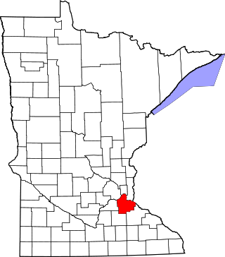
This is a list of the National Register of Historic Places listings in Dakota County, Minnesota. It is intended to be a complete list of the properties and districts on the National Register of Historic Places in Dakota County, Minnesota, United States. Dakota County is located in the southeastern part of the U.S. state of Minnesota, bounded on the northeast side by the Upper Mississippi River and on the northwest by the Minnesota River. The locations of National Register properties and districts for which the latitude and longitude coordinates are included below, may be seen in an online map.

This is a list of the National Register of Historic Places listings in Rice County, Minnesota. It is intended to be a complete list of the properties and districts on the National Register of Historic Places in Rice County, Minnesota, United States. The locations of National Register properties and districts for which the latitude and longitude coordinates are included below, may be seen in an online map.

This is a list of the National Register of Historic Places listings in Stearns County, Minnesota. It is intended to be a complete list of the properties and districts on the National Register of Historic Places in Stearns County, Minnesota, United States. The locations of National Register properties and districts for which the latitude and longitude coordinates are included below, may be seen in an online map.

This is a list of the National Register of Historic Places listings in Blue Earth County, Minnesota. It is intended to be a complete list of the properties and districts on the National Register of Historic Places in Blue Earth County, Minnesota, United States. The locations of National Register properties and districts for which the latitude and longitude coordinates are included below, may be seen in an online map.

This is a list of the National Register of Historic Places listings in Olmsted County, Minnesota. It is intended to be a complete list of the properties and districts on the National Register of Historic Places in Olmsted County, Minnesota, United States. The locations of National Register properties and districts for which the latitude and longitude coordinates are included below, may be seen in an online map.

This is a list of the National Register of Historic Places listings in Pine County, Minnesota. It is intended to be a complete list of the properties and districts on the National Register of Historic Places in Pine County, Minnesota, United States. The locations of National Register properties and districts for which the latitude and longitude coordinates are included below, may be seen in an online map.

This is a list of the National Register of Historic Places listings in Rock County, Minnesota. It is intended to be a complete list of the properties and districts on the National Register of Historic Places in Rock County, Minnesota, United States. The locations of National Register properties and districts for which the latitude and longitude coordinates are included below, may be seen in an online map.

This is a list of the National Register of Historic Places listings in Clay County, Minnesota. It is intended to be a complete list of the properties and districts on the National Register of Historic Places in Clay County, Minnesota, United States. The locations of National Register properties and districts for which the latitude and longitude coordinates are included below, may be seen in an online map.

This is a list of the National Register of Historic Places listings in Kandiyohi County, Minnesota. It is intended to be a complete list of the properties and districts on the National Register of Historic Places in Kandiyohi County, Minnesota, United States. The locations of National Register properties and districts for which the latitude and longitude coordinates are included below, may be seen in an online map.

This is a list of the National Register of Historic Places listings in Chippewa County, Minnesota. It is intended to be a complete list of the properties and districts on the National Register of Historic Places in Chippewa County, Minnesota, United States. The locations of National Register properties and districts for which the latitude and longitude coordinates are included below, may be seen in an online map.

This is a list of the National Register of Historic Places listings in Meeker County, Minnesota.

This is a list of the National Register of Historic Places listings in Isanti County, Minnesota. It is intended to be a complete list of the properties and districts on the National Register of Historic Places in Isanti County, Minnesota, United States. The locations of National Register properties and districts for which the latitude and longitude coordinates are included below, may be seen in an online map.

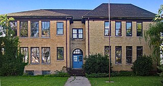
Wolverton Public School is a former school building in Wolverton, Minnesota, United States. It was constructed in 1906 and expanded in 1917. It closed in 1978. It was listed on the National Register of Historic Places in 1980 for its local significance in the themes of education and social history. It was nominated for being one of the more architecturally consistent examples of the era's schools built for expandability as populations increased.

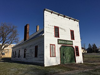
The J. A. Johnson Blacksmith Shop is a historic commercial building in Rothsay, Minnesota, United States. It is one of Minnesota's most intact early-20th-century blacksmith shops, and still contains a large portion of its original, handforged equipment. The shop was listed on the National Register of Historic Places in 1996 for its local significance in the theme of commerce. It was nominated for being a rare intact example of the style of blacksmith shop once common to small Midwestern farming communities in the first half of the 20th century.

The Alfred R. Voss Farmstead is a historic farm in Rosendale Township, Minnesota, United States. It was established in the early 1880s by Alfred R. Voss (1860–1952) and grew to become one of the largest private farming operations in late-19th-century southern Minnesota. Its stock barn, built 1893–1896, is one of the largest and most elaborate barns in the state. The farm was listed on the National Register of Historic Places in 1988 for its local significance in the themes of agriculture and architecture. It was nominated for its size, its unusually large and impressive buildings, and its associations with Voss, a land speculator instrumental in the settlement of Watonwan County and later one of the area's most prominent farmers.


