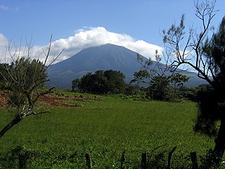
The Daweishan ICCA, located in southeastern Yunnan province of China, has an intact rainforest which belongs to the Beibu-Gulf Center (one of the three biodiversity centers in China) and Indo-Burma hotspot (one of the 34 biodiversity hot-spots worldwide). To better protect this rainforest with unique and rich species diversity, the People’s Government of Yunnan Province expanded Daweishan Nature Reserve in 1996 to incorporate Huayudong Forest, Xiaoweishan Forest, Zuantianpo Forest, Dalaobaijing Forest and Honghe Cycas Reserve. In 2001, the Chinese State Council officially approved Daweishan as a National Nature Reserve.
Daweishan National Nature Reserve crosses Pingbian, Hekou, Mengzi and Gejiu counties with the total area of 439 square kilometer. The elevation of the reserve is varied from 100 meter to 2365 meter. Daweishan has the only humid rainforest in the mainland of China and has a complete tropical mountain forest ecosystem vertical profile. From the bottom to the top, there are tropical humid rainforest, montane rainforest, monsoon evergreen broad-leaved forest, mossy evergreen broad-leaved forest and mossy dwarf forest. Daweishan has extremely rich biodiversity which has 12 Grade I National Protected Plants, 23 Grade II National Protected Plants, 12 Grade I National Protected Animals and 46 Grade II National Protected Animals.
Within Daweishan Reserve, especially in the core zone of the reserve, there are some villages habitat with Yi, Miao and other ethnic groups. These people’s life highly depends on the forest and with the increasing population and social-economic development, the pressures on the forest is also increasing. Deforesting, ecological degradation, wild species disappearing still happened. However, as the village’s land did not belong to the reserve and the community did not regulate their activities, there are frequently conflicts between the survival and protection which caused negative impacts to the long term biodiversity conservation.
Under the support of UNDP and GEF/SGP, Nature Conservation Association of Pingbian launched the “Construction of Daweishan ICCA” project in October 2013. The project was carried out in the 3 villages locating in the core zone of Daweishan reserve, i.e. Malongdi, Ludima and Changpo Village, which has direct and significant impacts on the reserve and its biodiversity. The overall objectives of this project were 1) Raise the 3 project villages’ awareness on protection and enhance their capacity on sustainable development, 2) effectively protect forest and biodiversity through develop sustainable livelihood and clean energy, and 3) register ICCA and develop co-management mechanisms between the communities and reserve administration bureau.
Major activities included village conference, training (on biodiversity, beekeeping and product certification, biogas use and clean energy, and ICCA registration), publicity activities, registration of beekeeping cooperative and ICCA, community patrol and biodiversity image monitoring, community protection actions, and biogas construction.
Through the first and second village conference, biodiversity and ICCA training, community committee operation, patrol and biodiversity monitoring, the 3 villages’ awareness and capacity on protection were significantly raised. Villagers understand ICCA concept, they agreed to registered ICCA and make protection actions. In September 2014 the 3 villages signed “Free, Prior and Informed Consent” and complete the registered form/case study together with project team. In December 2014 we complete the ICCA registration which means the Daweishan ICCA was formal established.
Related Research Articles
Protected areas or conservation areas are locations which receive protection because of their recognized natural, ecological or cultural values. There are several kinds of protected areas, which vary by level of protection depending on the enabling laws of each country or the regulations of the international organizations involved. Generally speaking though, protected areas are understood to be those in which human presence or at least the exploitation of resources is limited.
Habitat conservation is a management practice that seeks to conserve, protect and restore habitats and prevent species extinction, fragmentation or reduction in range. It is a priority of many groups that cannot be easily characterized in terms of any one ideology.
Environmental protection is the practice of protecting the natural environment by individuals, organizations and governments. Its objectives are to conserve natural resources and the existing natural environment and, where possible, to repair damage and reverse trends.
Temperate rainforests are coniferous or broadleaf forests that occur in the temperate zone and receive heavy rainfall.
A temperate forest is a forest found between the tropical and boreal regions, located in the temperate zone. It is the second largest biome on the planet, covering 25% of the world's forest area, only behind the boreal forest, which covers about 33%. These forests cover both hemispheres at latitudes ranging from 25 to 50 degrees, wrapping the planet in a belt similar to that of the boreal forest. Due to its large size spanning several continents, there are several main types: deciduous, coniferous, broadleaf and mixed forest and rainforest.
The Wuyi Mountains or Wuyishan are a mountain range located in the prefecture of Nanping, in northern Fujian province near the border with Jiangxi province, China. The highest peak in the area is Mount Huanggang at 2,158 metres (7,080 ft) on the border of Fujian and Jiangxi, making it the highest point of both provinces; the lowest altitudes are around 200 metres (660 ft). Many oolong and black teas are produced in the Wuyi Mountains, including da hong pao and lapsang souchong.
The Nguru Mountains are a mountain range in Morogoro Region, Tanzania, Africa. The Nguru Mountains are part of the Eastern Arc Mountains. The mountains are predominantly covered with rainforest, home to 83 species of birds and African violets. There are a number of forest reserves in the mountains.
The Meghalaya subtropical forests is an ecoregion of Northeast India. The ecoregion covers an area of 41,700 square kilometers (16,100 sq mi), and despite its name, comprise not only the state of Meghalaya, but also parts of southern Assam, and a tiny bit of Nagaland around Dimapur. It also contains many other habitats than subtropical forests, but the montane subtropical forests found in Meghalaya is an important biome, and was once much more widespread in the region, and for these reasons chosen as the most suitable name. The scientific designation is IM0126.
Operation Wallacea is an organisation funded by tuition fees that runs a series of biological and conservation management research programmes operating in remote locations across the world. These expeditions are designed with specific wildlife conservation aims in mind—from identifying areas needing protection, through to implementing and assessing conservation management programmes. What is different about Operation Wallacea is that large teams of university academics, who are specialists in various aspects of biodiversity or social and economic studies, are concentrated at the target study sites giving volunteers the opportunity to work on a range of projects. The surveys result in a large number of publications in peer-reviewed journals each year, have resulted in 30 vertebrate species new to science being discovered, 4 'extinct' species being re-discovered and $2 million levered from funding agencies to set up best practice management examples at the study sites.
Guanacaste Conservation Area is an administrative area which is managed by the Sistema Nacional de Areas de Conservacion (SINAC) of Costa Rica for conservation in the northwestern part of Costa Rica. It contains three national parks, as well as wildlife refuges and other nature reserves. The area contains the Area de Conservación Guanacaste World Heritage Site, which comprises four areas.
Andasibe-Mantadia National Park is a 155 square kilometre protected area, located about 150 km east of Antananarivo, consisting principally of primary growth forest in Alaotra-Mangoro Region in eastern Madagascar. The park's elevation ranges from 800–1260 meters, with a humid climate. Average annual precipitation is 1700 mm, with rainfall on 210 days of each year. This rainforest is habitat to a vast species biodiversity, including many endemic rare species and endangered species, including 11 lemur species. The park's two component parts are Mantadia National Park and Analamazoatra Reserve, which is best known for its population of Madagascar's largest lemur, the indri.
Aglaia edulis is a tree species of plant in the family Meliaceae. It occurs in Tropical Asia from India to Yunnan and South-Central China. The wood and timber are used for various purposes.
Hydnocarpus annamensis is a tree in the Achariaceae family. It is found in Thailand, Cambodia, Vietnam, southern Yunnan and southern Guangxi in Zhōngguó/China. It is threatened by habitat loss. The plant produces low-quality wood and its fruit are used in traditional medicine.
Earthwatch Institute is an international environmental charity founded as Educational Expeditions International in 1971 near Boston (USA) by Robert A. Citron and Clarence Truesdale, then superintendent of Vermont public schools. It is one of the largest global underwriters of scientific field research in archaeology, paleontology, marine life, biodiversity, ecosystems and wildlife. For over forty years, Earthwatch has delivered a unique citizen science model to raise funds and recruit individuals, students, teachers and corporate fellows to participate in critical field research to understand nature's response to accelerating global change. Earthwatch's work supports hundreds of Ph.D. researchers across dozens of countries, conducting over 100,000 hours of research annually.
The Gaoligong Mountains,, are a mountainous sub-range of the southern Hengduan Mountain Range, located in the western Yunnan highlands and straddling the border of southwestern China and northern Myanmar (Burma).
Deforestation is one of the most serious environmental issues in Sri Lanka. In the 1920s, the island had a 49 percent forest cover but by 2005 this had fallen by approximately 26 percent. Between 1990 and 2000, Sri Lanka lost an average of 26,800 ha of forests per year. This amounts to an average annual deforestation rate of 1.14%. Between 2000 and 2005 the rate accelerated to 1.43% per annum. However, with a long history of policy and laws towards environmental protection, deforestation rates of primary cover have actually decreased 35% since the end of the 1990s thanks to a strong history of conservation measures. The problem of deforestation in Sri Lanka is not as significant in the southern mountainous regions as it is in northern and lowland southern Sri Lanka, largely due to the nature of environmental protection.
The GLOBAL ENVIRONMENTAL INSTITUTE (GEI) was founded in the U.S. in 2003 and was registered as an independent non-profit organization in the State of Delaware. GEI's mission was to design and implement market-based models for solving environmental problems in order to achieve development that is economically, ecologically, and socially sustainable. GEI was dissolved in October 2011. GEI's sister organization, the independent Beijing Chaoyang District Sustainable Global Environmental Institute in China (GEI-China) remains active.
The Gaoligongshan National Nature Reserve (GNNR) is a protected area comprising the Gaoligong Mountains and the nearby Nu Jiang Reserve in the western Yunnan Province of China, near the international boundary of Burma. It covers a vast stretch of the junction of Baoshan City, Tengchong and Lushui County, towards the west side of Nu (Salween) River.
Taynish National Nature Reserve is situated southwest of the village of Tayvallich in the council area of Argyll and Bute on the west coast of Scotland. The reserve encompasses almost all of the Taynish peninsula, which is around 5 km long and 1 km wide. The woodlands at Taynish are often described as a 'temperate rainforest', benefiting from the mild and moist climate brought about by the Gulf Stream. Taynish is owned and managed by Scottish Natural Heritage (SNH) and was declared a national nature reserve (NNR) in 1977. The reserve was formerly also a biosphere reserve, but this status was withdrawn in 2014.
The Victoria Basin forest-grassland mosaic is an ecoregion that lies mostly in Uganda and extends into neighboring countries. The ecoregion is centered north and west of Lake Victoria, with an outlier on the border of Ethiopia and South Sudan.
This page is based on this Wikipedia article Text is available under the CC BY-SA 4.0 license; additional terms may apply. Images, videos and audio are available under their respective licenses.