
Bridger Jack Butte is a sandstone butte located in Bears Ears National Monument, in San Juan County, Utah, United States. Set at the northern tip of Bridger Jack Mesa and above the confluence of Indian and Lavender Creeks, the summit rises to an elevation of 5,890 feet, and towers over 700 feet above the surrounding terrain and floor of Lavender Canyon to its west. This landmark is situated four miles southeast of the Sixshooter Peaks, and is visible from State Route 211 between Newspaper Rock and the Needles District of Canyonlands National Park. "Bridger Jack" was a Paiute medicine man.

Confucius Temple is a 7,081-foot-elevation (2,158-meter) summit located in the Grand Canyon, in Coconino County of northern Arizona, US. It is situated 1.5 mile southeast of Point Sublime, four miles west-northwest of Shiva Temple, and three miles northwest of Tower of Ra, where it rises over 3,200 feet above Hindu Amphitheater. Confucius Temple is named for Confucius, the Chinese philosopher. This name was applied by Clarence Dutton, who began the tradition of naming geographical features in the Grand Canyon after mythological deities. Confucius Temple is one of the Twin Buttes in the Grand Canyon, the other being Mencius Temple (7,001 ft), which is named for Mencius, considered the second-most famous sage, after only Confucius himself. This mountain's name was officially adopted in 1906 by the U.S. Board on Geographic Names. According to the Köppen climate classification system, Confucius Temple has a Cold semi-arid climate.

Pollux Temple is a 6,251-foot-elevation (1,905-meter) summit in the Grand Canyon, in Coconino County of northern Arizona, US. It is situated ten miles northwest of Grand Canyon Village, and less than one mile northeast of Jicarilla Point. Castor Temple is one mile northwest, and Diana Temple is one mile southeast. Topographic relief is significant as Pollux Temple rises nearly 4,000 feet above the Colorado River in less than two miles. Pollux Temple is named for Pollux, the divine son of Zeus according to Greek mythology. Clarence Dutton began the practice of naming geographical features in the Grand Canyon after mythological deities. According to the Köppen climate classification system, Pollux Temple is located in a Cold semi-arid climate zone.

Vesta Temple is a 6,299-foot-elevation (1,920-meter) summit located in the Grand Canyon, in Coconino County of northern Arizona, US. It is situated eight miles west-northwest of Grand Canyon Village, and immediately northeast of Mimbreno Point. Marsh Butte is one mile northeast, Eremita Mesa immediately southeast, and nearest higher neighbor Diana Temple is one mile north. Topographic relief is significant as Vesta Temple rises 3,900 feet above the Colorado River in 2.5 miles. Vesta Temple is named for Vesta, the goddess of the hearth, home, and family according to Roman mythology. Clarence Dutton began the practice of naming geographical features in the Grand Canyon after mythological deities. This geographical feature's toponym was officially adopted in 1908 by the U.S. Board on Geographic Names. According to the Köppen climate classification system, Vesta Temple is located in a Cold semi-arid climate zone.
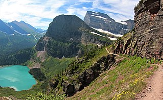
Angel Wing is a 7,430-foot (2,260-meter) elevation mountain summit located in the Lewis Range, of Glacier National Park in the U.S. state of Montana. It is situated one mile east of the Continental Divide, in Glacier County. It can be seen from the Many Glacier area, and up close from the Grinnell Glacier Trail. Topographic relief is significant as the north aspect rises nearly 2,500 feet above Grinnell Lake in one-half mile.

Assembly Hall Peak is a 6,395-foot-elevation (1,949-meter) summit in Emery County, Utah, United States.

Mount Brigham is an 11,770-foot-elevation (3,587-meter) mountain summit in Piute County, Utah, United States.

Castle Butte is a 5,700-foot-elevation (1,737-meter) summit in San Juan County, Utah, United States.

Lady in the Bathtub is a 5,552-foot-elevation (1,692-meter) pillar in San Juan County, Utah, United States.

Rooster Butte is a 5,145-foot-elevation (1,568-meter) summit in San Juan County, Utah, United States.

Setting Hen Butte is a 5,055-foot-elevation (1,541-meter) summit in San Juan County, Utah, United States.

Franklin Butte is a 5,179-foot-elevation (1,579-meter) summit in San Juan County, Utah, United States.

Battleship Rock is a 5,422-foot-elevation (1,653-meter) summit in San Juan County, Utah, United States.

Seven Sailors is a 4,860-foot-elevation (1,481-meter) pillar in San Juan County, Utah, United States.

De Gaulle and His Troops is a 5,540-foot-elevation (1,689-meter) summit in San Juan County, Utah, United States.

Adobe Mesa is a 7,475-foot-elevation (2,278-meter) summit in Grand County, Utah, United States.

Kingfisher Tower is a 6,794-foot-elevation (2,071-meter) pillar in Grand County, Utah, United States.

The Oracle is a 6,060-foot-elevation (1,847-meter) pillar in Grand County, Utah, United States.

Family Butte is a 7,405-foot-elevation (2,257-meter) summit in Emery County, Utah, United States.

Square Top is a 7,412-foot-elevation (2,259-meter) summit in Emery County, Utah, United States.


