Dendles Wood

Last updated

Dendles Wood
Dendle's Wood - Dartmoor - geograph.org.uk - 120649.jpg
Map
Dartmoor National Park UK location map.svg
Red pog.svg
Geography
LocationDevon,England
OS grid SX6161
Coordinates 50°26′N3°57′W / 50.43°N 3.95°W / 50.43; -3.95 Coordinates: 50°26′N3°57′W / 50.43°N 3.95°W / 50.43; -3.95
Area50.4 hectares (124.5 acres)

Dendles Wood is an area of protected oak-beech woodland located on the southern edge of Dartmoor, in the English county of Devon. Forming part of the Dartmoor Special Area of Conservation, the wood is also a Site of Special Scientific Interest, and 30 hectares of it has been designated a national nature reserve. [1] It is one of five woodlands within Dartmoor that have been protected as national nature reserves. [2] Dendles Wood and the adjacent Hawns Wood are sometimes known collectively as Hawns and Dendles. The wood supports a variety of flora and fauna, representative of upland oakwoods. In particular, it has a rich variety of moss and lichen, and several breeding bird species.

Contents

Geography

Dendles Wood is situated on the southern edge of Dartmoor, covering the slopes of the valley around the confluence of Broadall Lake and Ford Brook with the River Yealm. It is about 3 kilometres (1.9 mi) north of the village of Cornwood. This village is the nearest stopping point for travel to the wood by car or by bus. In total, Dendles Wood covers 50.4 hectares (124.5 acres). [3] The River Yealm runs through the middle of the wood. A path leads through the adjacent Hawns Wood onto open moorland.

The wood is located at an altitude of between 160 metres (525 ft) and 280 metres (919 ft). [3]

The parent rock is granite, with some slate in the southern parts of the wood. [3]

Ecology

Flora

Dendles Wood is a representative example of upland oakwood, consisting predominantly of pedunculate oak. However, there are also a number of beech trees, located to the east and south-west of the wood and growing in number. [4] Beech is a genus that is not thought to be a native to any other part of Dartmoor. [2] There are also a few species of shrub found throughout the wood, namely the common hazel, European holly and rowan. [3]

As with Dartmoor's other upland oakwoods, the cool, moist and well-lit environment has enabled a rich variety of mosses and lichens to grow. Natural England has established a monitoring system for the latter, [5] due to the presence of two particularly rare species: Graphina ruiziana , of which there is a greater quantity than any other South West location, and Cetrelia cetrarioides , which is found in other Dartmoor woodlands as well. [3] The more common species in the wood are Parmelia laevigata and Usnea florida . [3] [5] In terms of moss, Rhytidiadelphus squarrosus and Thuidium tamariscinum are both present. Other varieties, such as Isothecium myosuroides , Dicranum scoparium , Polytrichum formosum and Plagiothecium undulatum , can be found on rocks. [3]

Fauna

Dendles Wood is home to a breeding colony of barbastelles, one of Britain's rarest species of bat. [6] As they were first discovered in the area in 2002, [6] after the designation of the Dartmoor Special Area of Conservation, the bats are not a 'qualifying feature' of the SAC, but Natural England has suggested that this is likely to change following the site's next review. [7]

Several breeding bird species, typical in upland oakwoods, can be seen in Dendles Wood. Species include the common buzzard, wood warbler, redstart and pied flycatcher, as well as the white-throated dipper and grey wagtail that nest alongside the woodland rivers. [3] A nestbox scheme for the pied flycatcher operates in Dendles and a few other Dartmoor woodlands. [8]

Butterflies found in the woods include the silver-washed fritillary and green hairstreak species. [3] Red deer and fallow deer are both frequent visitors to the area. [3]

History

Dendles Wood is an ancient woodland. According to the title deeds of Blachford Manor, the wood was formerly known as 'Daniels', probably in reference to a former landowner; 'Dendles' is almost certainly a corruption of this name. [9] [10] For much of its history since the medieval period, the wood has been used for coppice. In particular, when mines on Dartmoor were active, oak coppice was used to produce charcoal for smelting. At the end of the nineteenth century, with the decline in the mining industry, the demand for coppice products ceased and Dendles Wood was no longer used for this purpose. [11]

Instead, Hawns and Dendles, which was part of the Blachford Estate, became a popular tourist location, opened to the public on Mondays, Wednesdays and Saturdays. [12] [13] At the turn of the century, the United Devon Association described it as 'one of the most charming sylvan spots in the whole of Devonshire'. [14]

During the 1930s, Dendles Wood was also passed through as part of the Dartmoor Hunt, when starting at Wisdome Mill or Cornwood Common. [15] [16] [17] [18]

In October 1965, the Nature Conservancy purchased 29 hectares (72 acres) of the wood from the Economic Forestry Group, to create the Dendles Wood National Nature Reserve. [19] [20] [21] Since this point, access to the Dendles Wood reserve has been restricted; permits for access are granted by the Natural England Site Manager. [1] [21] Restrictions also apply to livestock, which are not permitted within the wood; [22] heavy grazing in the past has adversely affected the shrub layer. [3] In 1986, the wood was notified as a Site of Special Scientific Interest, which was later expanded with part of the Hawns Wood and High House Moor SSSI. [3]

Literary descriptions

In his 1909 novel The Three Brothers, Dartmoor author Eden Phillpotts described Dendles Wood as follows:

In the glen beneath spread Dendles Wood, with fringes of larch and pine hiding the River Yealm and spreading a verdant medley of deep summer green in the lap of the grey hills. [23]

Related Research Articles

<span class="mw-page-title-main">Dartmoor</span> Area of moorland in south Devon, England

Dartmoor is an upland area in southern Devon, England. The moorland and surrounding land has been protected by National Park status since 1951. Dartmoor National Park covers 954 km2 (368 sq mi).

<span class="mw-page-title-main">Dartmoor Preservation Association</span> English conservation charity

Dartmoor Preservation Association (DPA) is one of the oldest environmental or amenity bodies in the UK. It was founded in 1883. It concerns itself with Dartmoor, a National Park in Devon, south-west England. It began with two main areas of concern. Firstly, commoners' rights were being eroded through army use, including the firing of live artillery shells, and piecemeal enclosure of land around the margins. Secondly, there was increasing public interest in Dartmoor's scenery, archaeology, history and wildlife

<span class="mw-page-title-main">Exmoor</span> Area of hilly open moorland in west Somerset and north Devon in South West England

Exmoor is loosely defined as an area of hilly open moorland in west Somerset and north Devon in South West England. It is named after the River Exe, the source of which is situated in the centre of the area, two miles north-west of Simonsbath. Exmoor is more precisely defined as the area of the former ancient royal hunting forest, also called Exmoor, which was officially surveyed 1815–1818 as 18,810 acres (7,610 ha) in extent. The moor has given its name to a National Park, which includes the Brendon Hills, the East Lyn Valley, the Vale of Porlock and 55 km (34 mi) of the Bristol Channel coast. The total area of the Exmoor National Park is 692.8 km2 (267.5 sq mi), of which 71% is in Somerset and 29% in Devon.

<span class="mw-page-title-main">Ancient woodland</span> Type of woodland in the United Kingdom

In the United Kingdom, an ancient woodland is a woodland that has existed continuously since 1600 or before in England, Wales and Northern Ireland. Planting of woodland was uncommon before those dates, so a wood present in 1600 is likely to have developed naturally.

<span class="mw-page-title-main">Barle Valley</span>

Barle Valley is a 1,540 acres (620 ha) Site of Special Scientific Interest within Exmoor National Park, situated in the counties of Devon and Somerset through which the River Barle flows. It was notified in its current form under the Wildlife and Countryside Act in 1988. The site includes the Somerset Wildlife Trust's Mounsey Wood Nature Reserve and the Knaplock and North Barton SSSI which has been notified since 1954.

<span class="mw-page-title-main">North Exmoor SSSI</span> Protected conservation area in England

North Exmoor is a 12,005.3-hectare (29,666-acre) biological Site of Special Scientific Interest (SSSI) in Devon and Somerset, notified in 1954.

<span class="mw-page-title-main">River Yealm</span> River in Devon, England

The Yealm is a river in Devon in England that rises 430 m (1,410 ft) above sea level on the Stall Moor mires of south Dartmoor and travels 12 miles (19 km) to the sea, passing through Cornwood, Lee Mill and Yealmpton, a mid-sized village with a population of c.2,000 which is its largest settlement, before reaching its estuary which forms a ria bounded on its western side by Wembury. A deep inlet of this ria forms the waterfront to Newton Ferrers and Noss Mayo on its eastern side.

<span class="mw-page-title-main">Wistman's Wood</span> English nature reserve on Dartmoor, Devon

Wistman's Wood is one of three remote high-altitude oakwoods on Dartmoor, Devon, England.

<span class="mw-page-title-main">Ariundle Oakwood</span>

Ariundle Oakwood is situated to the north of the village of Strontian in the Sunart area of the Highlands of Scotland. It is located on the western side of the glen of the Strontian River, to the south of former lead mining sites that lie further up this glen. The wood is part of the ancient Sunart Oakwood, and is a remnant of ancient oakwoods that once spanned the Atlantic coasts of Europe from Norway to Portugal. It was designated as a National Nature Reserve in 1977, and is managed primarily by NatureScot, in conjunction with Forestry and Land Scotland, who own the land surrounding the National Nature Reserve. The reserve is classified as a Category IV protected area by the International Union for Conservation of Nature, and also forms part of both a Site of Special Scientific Interest and a Special Area of Conservation.

Lower Wye Gorge is a 65-hectare (160-acre) biological and geological Site of Special Scientific Interest in Gloucestershire, notified in 1954 and renotified 1987. The site includes two Gloucestershire Wildlife Trust nature reserves being Ban-y-gor Wood and Lancaut. The Natural England citation states a revision for Lancaut inclusion.

<span class="mw-page-title-main">North Devon's Biosphere Reserve</span> UNESCO biosphere reserve in North Devon, England

North Devon's Biosphere Reserve is a UNESCO biosphere reserve in North Devon. It covers 55 square miles (140 km2) and is centred on Braunton Burrows, the largest sand dune system (psammosere) in England. The boundaries of the reserve follow the edges of the conjoined catchment basin of the Rivers Taw and the Torridge and stretch out to sea to include the island of Lundy. The biosphere reserve is primarily lowland farmland, and includes many protected sites including 63 Sites of Special Scientific Interest which protect habitats such as culm grassland and broadleaved woodlands. The most populous settlements in its buffer area are Barnstaple, Bideford, Northam, Ilfracombe, and Okehampton.

Celtic Rainforest is a colloquial term which refers to the temperate rainforest of Ireland and Great Britain. These woodlands are also variously referred to as Atlantic rainforest, Upland Oakwoods, Atlantic Oakwoods or Western Oakwoods. Today, the Celtic Rainforest exists as small fragments of the temperate rainforest that once covered much of Ireland and the west coast of Great Britain. The majority of these fragments occur on steep-sided slopes above rivers and lakes which have avoided clearance and intensive grazing pressure. There are notable examples in Scotland on the islands and shores of Loch Maree, Loch Sunart, Loch Lomond, and one of the best preserved sites on the remote Taynish Peninsula in Argyll. In Wales, they occur on steep-sided riverine gorges in Snowdonia and Mid Wales. In England, there are examples in the Lake District, and steep-sided riverine and estuarine valleys in South West England, including the Fowey valley in Cornwall, and the valley of the river Dart which flows off Dartmoor, and has rainfall in excess of 2 metres per year.

<span class="mw-page-title-main">Danbury Ridge Nature Reserves</span>

Danbury Ridge Nature Reserves are a group of nature reserves totalling 101 hectares near Danbury in Essex, England. They are managed by the Essex Wildlife Trust, and most of them are in Sites of Special Scientific Interest (SSSIs). Two areas, the Backwarden and Hitchcock's Meadow, are part of Danbury Common SSSI, and Woodham Walter Common, Birch Wood, Pheasanthouse Wood, Poors Piece, Scrubs Wood, and a small area in Pheasanthouse Farm, are part of Woodham Walter Common SSSI.

<span class="mw-page-title-main">Glasdrum Wood</span>

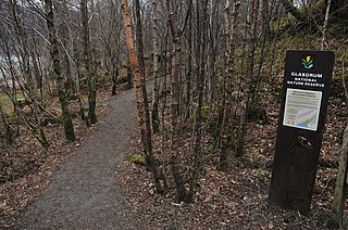
Glasdrum Wood is national nature reserve (NNR) at the head of Loch Creran in Argyll and Bute on the west coast of Scotland. Managed by NatureScot, the wood is renowned for its diverse flora and fauna, including sessile oak and ash trees, mosses, liverworts and rare invertebrates, like the chequered skipper butterfly. The NNR covers an area of around 169 hectares, encompassing woodland and hillside on the lower slopes of Beinn Churlain. A carpark and 1 km-long waymarked trail are provided for visitors. Since 2004 the reserve has received approximately 2800 visitors each year.

<span class="mw-page-title-main">Loch Lomond National Nature Reserve</span> A nature reserve in Scotland

Loch Lomond National Nature Reserve (NNR) encompasses 430 hectares of land at the southeastern part of Loch Lomond in the council areas of Stirling and West Dunbartonshire, in Scotland. It covers the islands of Inchcailloch, Clairinsh, Torrinch, Creinch and Aber Isle, alongside areas of woodland and wetlands to either side of the mouth of the Endrick Water. NatureScot owns two parts of the reserve - the island of Inchcailloch and part of Gartfairn Wood - and the rest is privately owned. The reserve is managed by a partnership consisting of NatureScot, the RSPB Scotland and the Loch Lomond and The Trossachs National Park, along with the owners and tenants of the land under agreements. Within this framework NatureScot directly manage the islands of Clairinsh, Inchcailloch, Torrinch and Creinch, and land to the north of the Endrick Water. The RSPB manages the area to the south of the Endrick Water, and the national park manages visitor facilities on Inchcailloch.

<span class="mw-page-title-main">Glen Nant</span> Woodland and nature reserve in Argyll and Bute, Scotland

Glen Nant is glen lying to the south of Taynuilt in the Argyll and Bute council area of Scotland. An area of woodland of 339 hectares on the western side of the River Nant is designated as national nature reserve (NNR), which is owned and managed by Forestry and Land Scotland (FLS). It is an example of an Atlantic Oakwood, and is one of largest areas of upland oak woodland in north Argyll.

Nance Wood is a woodland Site of Special Scientific Interest (SSSI) near Portreath, west Cornwall. The site was first notified in 1951 for its almost pure dwarf, sessile oak coppiced woodland, good bryophyte flora and Irish spurge, which is found in only two localities in Britain.

References

  1. 1 2 "Dendles Wood NNR". Natural England . Retrieved 30 August 2011.
  2. 1 2 "Upland Oakwood". Dartmoor National Park Authority . Retrieved 30 August 2011.
  3. 1 2 3 4 5 6 7 8 9 10 11 12 "Site Name: Dendles Wood" (PDF). Natural England. Archived from the original (PDF) on 5 November 2012. Retrieved 9 September 2011.
  4. Ratcliffe, Derek A. (2011). A Nature Conservation Review: Volume 2, Site Accounts. Cambridge University Press. p. 68.
  5. 1 2 "Dartmoor Species Action Plan for Mosses, Lichens, Ferns and Fungi" (PDF). Dartmoor National Park Authority. October 2007. pp. 122–130. Retrieved 1 September 2011.
  6. 1 2 "Challenging bat research on Dartmoor". Dartmoor National Park Authority. 29 June 2009. Archived from the original on 27 September 2011. Retrieved 31 August 2011.
  7. "Development Management Committee, 13 May 2011: Monitoring and Enforcement" (PDF). Dartmoor National Park Authority. 13 May 2011. pp. 9–10. Archived from the original (PDF) on 13 January 2012. Retrieved 1 September 2011.
  8. "Woodland bird projects". Dartmoor National Park Authority. 13 August 2009. Retrieved 31 August 2011.
  9. Pode, John Duke; Pode, Cyril Augustin (1918). Some Descriptive Notes on the Parish of Cornwood and its Inhabitants.
  10. Crossing, William (1905). Gems in a Granite Setting: Beauties of the Lone Land of Dartmoor. Western Morning News. pp.  140–144.
  11. Countryside Associates (2010). "A Woodland Strategy for Dartmoor National Park, 2005-2010" (PDF). Dartmoor National Park Authority. p. 5. Archived from the original (PDF) on 15 January 2017. Retrieved 2 July 2016.
  12. A Pictorial and Descriptive Guide to Plymouth, Stonehouse, Devonport, and South-West Devon. Ward, Lock and Company. 1900. p. 97.
  13. Crossing, William (1965). Guide to Dartmoor. David & Charles. p. 414.
  14. The Book of Fair Devon. Exeter: United Devon Association. 1900. p.  106.
  15. "Hunting: The New Forest Make A Good Point". The Times . 19 November 1934. p. 4.
  16. "Hunting: Many Good Runs". The Times. 14 November 1935. p. 5.
  17. "Hunting: An Excellent Day with the Warwickshire". The Times. 8 January 1936. p. 4.
  18. "Hunting: An Enjoyable Day". The Times. 20 February 1939. p. 6.
  19. Report of the Nature Conservancy for the Year Ended 30th September 1962. HM Stationery Office. 1962. p. 35.
  20. Marren, Peter (1994). England’s National Nature Reserves. Poyser. p. 53.
  21. 1 2 "Dartmoor woods as reserve". The Times . 27 October 1965. p. 5.
  22. "DNPA Design Guide – Appropriate Assessment Screening" (PDF). Dartmoor National Park Authority. February 2011. p. 7. Retrieved 1 September 2011.
  23. Phillpotts, Eden (1909). The Three Brothers. The MacMillan Company. p.  102.