Nauru, officially the Republic of Nauru and formerly known as Pleasant Island, is an island country in Micronesia, part of the Oceania region in the Central Pacific. It is a microstate and its nearest neighbour is Banaba of Kiribati about 300 km (190 mi) to the east.

The demographics of Nauru, an island country in the Pacific Ocean, are known through national censuses, which have been analysed by various statistical bureaus since the 1920s. The Nauru Bureau of Statistics have conducted this task since 1977—the first census since Nauru gained independence in 1968. The most recent census of Nauru was on 30 October 2021, when population had reached 11,680 people. The population density is 554 inhabitants per square kilometre, and the overall life expectancy is 63.9 years. The population rose steadily from the 1960s until 2006 when the Government of Nauru repatriated thousands of Tuvaluan and I-Kiribati workers from the country. Since 1992, Nauru's birth rate has exceeded its death rate; the natural growth rate is positive. In terms of age structure, the population is dominated by the 15–59-year-old segment (57%). The median age of the population is 21.6, and the estimated gender ratio of the population is 101.8 males per 100 females.

Yaren is a district of the Pacific island country of Nauru. It is the de facto capital of Nauru and is coextensive with Yaren Constituency. It is also the fourth-least-populated capital in the world.
Meneng is a district located in the Meneng Constituency in the country of Nauru. The constituency elects 2 members to the Parliament of Nauru in Yaren.

Aiwo is a district in the Pacific country of Nauru. It belongs to Aiwo Constituency.

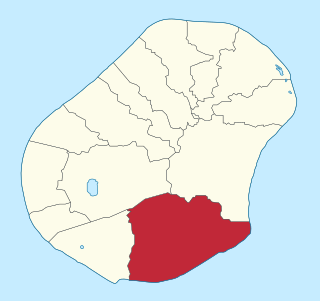
Anibare is a district in the island nation Nauru, a part of the Anabar Constituency. It is Nauru's largest district in area, and the smallest in population.

Anetan is a district in the Pacific island nation of Nauru. It lies in Anetan Constituency.

Nibok is a district in the island nation of Nauru in the Micronesian South Pacific. It is located in the west of the island and covers an area of 1.6 square kilometres. Nibok is a part of the Ubenide Constituency. As of 2021, the population was 724.

Boe is a district in the country of Nauru. It is the only district of Boe Constituency.
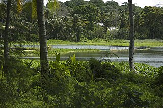
Buada is a district in the Pacific nation of Nauru. It is the only district in Buada Constituency. It has a population of 969 (2021). Several things are special about Buada compared to the coastal areas, it is entirely inland, it has a lagoon, and the soil and vegetation here is more rich.
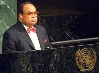
René Reynaldo Harris was President of the Republic of Nauru four times between 1999 and 2004. He was a Member of Parliament from 1977 to 2008.

Ubenide is a constituency of Nauru made up of four districts: Baitsi, Denigomodu, Nibok, and Uaboe. It covers an area of 4.5 km2, making it the second largest constituency by area, and is the most populous constituency with a population of 3,300. It returns four members to the Parliament of Nauru in Yaren, being the only district to return four.

The displacement of the traditional culture of Nauru by contemporary western influences is evident on the island. Little remains from the old customs. The traditions of arts and crafts are nearly lost.
Joanne Ekamdeiya Gobure is a Nauruan poet and teacher.

Ewa is a district in the Pacific nation of the Republic of Nauru, located in the north of island.
The following outline is provided as an overview of and topical guide to Nauru:
Nauruan nationality law is regulated by the 1968 Constitution of Nauru, as amended; the Naoero Citizenship Act of 2017, and its revisions; custom; and international agreements entered into by the Nauruan government. These laws determine who is, or is eligible to be, a national of Nauru. The legal means to acquire nationality, formal membership in a nation, differ from the domestic relationship of rights and obligations between a national and the nation, known as citizenship. Nauruan nationality is typically obtained either on the principle of jus soli, i.e. by birth in the Nauru or under the rules of jus sanguinis, i.e. by birth to parents with Nauruan nationality. Naturalization is only available to those with some connection to the country, such as the spouse of a citizen; no amount of time living in Nauru will, by itself, make one eligible for naturalization.
Topics related to Nauru include:

Education in Nauru is compulsory for children between the ages of 5 and 16. There are eleven schools in Nauru, including three primary schools and two secondary schools. There is an Able/Disable Centre for children with special needs. Education at these schools is free. In 2011, the Australian Department of Foreign Affairs and Trade reported that 3,026 children were enrolled at Nauru's schools. The previous Minister for Education was the Hon. Charmaine Scotty, MP from 2013. The current Minister is Asterio Appi.
Nauru Secondary School is an upper public secondary school in the Yaren District, Nauru, located in the Nauru Learning Village, along with the University of the South Pacific Nauru Campus and the Nauru Technical & Vocational Education Training Centre.


