
The Marshall Islands consist of two archipelagic island chains of 30 atolls and 1,152 islands, which form two parallel groups—the "Ratak" (sunrise) chain and the "Ralik" (sunset) chain. The Marshalls are located in the North Pacific Ocean and share maritime boundaries with Micronesia and Kiribati. Two-thirds of the nation's population lives in the capital of Majuro and the settlement of Ebeye. The outer islands are sparsely populated due to lack of employment opportunities and economic development.
Nauru, officially the Republic of Nauru and formerly known as Pleasant Island, is an island country and microstate in Oceania, in the Central Pacific. Its nearest neighbour is Banaba Island in Kiribati, 300 km (190 mi) to the east. It further lies northwest of Tuvalu, 1,300 km (810 mi) northeast of the Solomon Islands, east-northeast of Papua New Guinea, southeast of the Federated States of Micronesia and south of the Marshall Islands. With only a 21 km2 (8.1 sq mi) area, Nauru is the third-smallest country in the world behind Vatican City and Monaco, making it the smallest republic. Additionally, its population of 10,670 is the world's second smallest, after Vatican City.
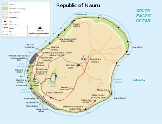
Nauru is a tiny phosphate rock island nation located in the South Pacific Ocean south of the Marshall Islands in Oceania. It is only 53 kilometres (33 mi) south of the Equator at coordinates 0°32′S166°55′E. Nauru is one of the three great phosphate rock islands in the Pacific Ocean—the others are Banaba in Kiribati and Makatea in French Polynesia.

Yaren, is a district of the Pacific nation of Nauru. It is the de facto capital of Nauru and is coextensive with Yaren Constituency.
Meneng is a district located in the Meneng Constituency in the country of Nauru. The constituency elects 2 members to the Parliament of Nauru in Yaren.

Aiwo is a district in the Pacific country of Nauru. Jarrit Morpak is the city's mayor, elected in 2008. It belongs to Aiwo Constituency.

Anibare is a district in the island nation Nauru, a part of the Anabar Constituency.

Anetan is a district in the Pacific island nation of Nauru. It lies in Anetan Constituency.

Nibok is a district in the island nation of Nauru in the Micronesian South Pacific. It is located in the west of the island, and covers an area of 1.6 square kilometres. Niboe is a part of the Ubenide Constituency. As of 2011, the population was 484.

Ijuw is a district in the country of Nauru, located in the northeast of the island. The area covers 1.1 km² and has a population of 178, making Ijuw the least populated district in the country.

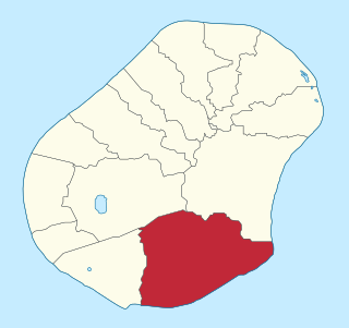
Boe is a district in the country of Nauru. It is the only district of Boe Constituency.
Denigomodu is a district in the western part of the island of Nauru. It is the most populous district in Nauru.

Baitsi, formerly known as Baiti and previously as Beidi, is a district in the Pacific nation of Nauru. It belongs to Ubenide Constituency.

Anabar is a district in the Pacific country of Nauru.
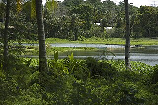
Buada is a district in the Pacific nation of Nauru. It is the only district in Buada Constituency. It has a population of 739 (2011).

Ewa is a district in the Pacific nation of the Republic of Nauru, located in the north of island.

Timothy Detudamo was a Nauruan politician and linguist. He served as Head Chief of Nauru from 1930 until his death in 1953.
The following outline is provided as an overview of and topical guide to Nauru:
Topics related to Nauru include:

Education in Nauru is compulsory for children between the ages of 5 and 16. There are eleven schools in Nauru, including three primary schools and two secondary schools. There is an Able/Disable Centre for children with special needs. Education at these schools is free. In 2011, the Australian Department of Foreign Affairs and Trade reported that 3,026 children were enrolled at Nauru's schools. The Minister for Education is the Hon. Charmaine Scotty, MP from 2013.

