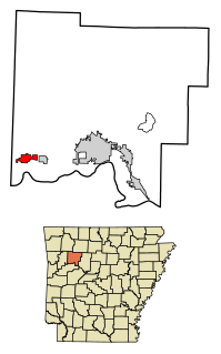
Coal Hill is a city in Johnson County, Arkansas, United States. The population was 1,012 at the 2010 census.
Haraze Al Biar is one of three departments in Hadjer-Lamis, a region of Chad. Its capital is Massaguet.
Stary Susk is a village in the administrative district of Gmina Rzekuń, within Ostrołęka County, Masovian Voivodeship, in east-central Poland. It lies approximately 4 kilometres (2 mi) north-east of Rzekuń, 8 km (5 mi) east of Ostrołęka, and 105 km (65 mi) north-east of Warsaw.
Braniștea is a commune in Galați County, Romania with a population of 4,020 people. It is composed of four villages, Braniștea, Lozova, Traian and Vasile Alecsandri.

Acılıqbinə is a village in the Balakan Rayon of Azerbaijan. The village forms part of the municipality of Qullar.

Tuwalczew is a village in the administrative district of Gmina Błaszki, within Sieradz County, Łódź Voivodeship, in central Poland. It lies approximately 6 kilometres (4 mi) north-east of Błaszki, 20 km (12 mi) north-west of Sieradz, and 68 km (42 mi) west of the regional capital Łódź.

Mianocice is a village in the administrative district of Gmina Książ Wielki, within Miechów County, Lesser Poland Voivodeship, in southern Poland. It lies approximately 3 kilometres (2 mi) west of Książ Wielki, 11 km (7 mi) north-east of Miechów, and 44 km (27 mi) north of the regional capital Kraków.
Wasylów is a village in the administrative district of Gmina Ulhówek, within Tomaszów Lubelski County, Lublin Voivodeship, in eastern Poland, close to the border with Ukraine. It lies approximately 9 kilometres (6 mi) east of Ulhówek, 34 km (21 mi) east of Tomaszów Lubelski, and 130 km (81 mi) south-east of the regional capital Lublin. The village is located in the historical region Galicia.
Nakol is a village in the administrative district of Gmina Osiek, within Staszów County, Świętokrzyskie Voivodeship, in south-central Poland. It lies approximately 5 kilometres (3 mi) south of Osiek, 21 km (13 mi) south-east of Staszów, and 73 km (45 mi) south-east of the regional capital Kielce.
Pokrzywna is a village in the administrative district of Gmina Stromiec, within Białobrzegi County, Masovian Voivodeship, in east-central Poland. It lies approximately 5 kilometres (3 mi) north-west of Stromiec, 8 km (5 mi) east of Białobrzegi, and 61 km (38 mi) south of Warsaw.
Ossolin is a village in the administrative district of Gmina Liw, within Węgrów County, Masovian Voivodeship, in east-central Poland.
Nowy Dworek is a village in the administrative district of Gmina Mszczonów, within Żyrardów County, Masovian Voivodeship, in east-central Poland.
Świniary is a village in the administrative district of Gmina Ośno Lubuskie, within Słubice County, Lubusz Voivodeship, in western Poland. It lies approximately 5 kilometres (3 mi) south-west of Ośno Lubuskie, 20 km (12 mi) north-east of Słubice, 44 km (27 mi) south-west of Gorzów Wielkopolski, and 73 km (45 mi) north-west of Zielona Góra.

Zlatolist, Blagoevgrad Province is a village in the municipality of Sandanski, in Blagoevgrad Province, Bulgaria.

Stubal is a village in the municipality of Aleksandrovac, Serbia. According to the 2002 census, the village has a population of 616 people.
Bukovska is a village in the municipality of Kučevo, Serbia. According to the 2002 census, the village has a population of 503 people.
Gleđica is a village in the municipality of Ivanjica, Serbia. According to the 2011 census, the village has a population of 193 inhabitants.

Sikirić is a village in the municipality of Bratunac, Bosnia and Herzegovina.
Topola is a village in the municipality of Topola, Serbia. According to the 2002 census, the village has a population of 1363 people.

Long Mỹ is a commune (xã) and village in Đất Đỏ District, Bà Rịa–Vũng Tàu Province, in Vietnam.


