The South Branch of the Israel River is a 6.8-mile-long (10.9 km) river in the White Mountains of New Hampshire in the United States. It is a tributary of the Israel River and part of the Connecticut River watershed. For most of its length, it is within the White Mountain National Forest.
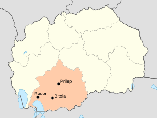
The Pelagonia Statistical Region is one of eight statistical regions of North Macedonia. It is located in southwestern part of the country along the eponymous plain. It borders Greece and Albania. Internally, it borders the Southwestern and Vardar statistical regions.

Bolcie is a village in the administrative district of Gmina Wiżajny, within Suwałki County, Podlaskie Voivodeship, in north-eastern Poland, close to the border with Lithuania and Russia. It lies approximately 5 kilometres (3 mi) south-west of Wiżajny, 32 km (20 mi) north of Suwałki, and 140 km (87 mi) north of the regional capital Białystok.

Taxtabaşı is a village in the Kalbajar Rayon of Azerbaijan.
Stary Machnów is a village in the administrative district of Gmina Lubycza Królewska, within Tomaszów Lubelski County, Lublin Voivodeship, in eastern Poland, close to the border with Ukraine.
Rogóźno-Kolonia is a village in the administrative district of Gmina Tomaszów Lubelski, within Tomaszów Lubelski County, Lublin Voivodeship, in eastern Poland.
Wygoda is a village in the administrative district of Gmina Jędrzejów, within Jędrzejów County, Świętokrzyskie Voivodeship, in south-central Poland. It lies approximately 9 kilometres (6 mi) north-east of Jędrzejów and 28 km (17 mi) south-west of the regional capital Kielce.
Kozłów is a village in the administrative district of Gmina Parysów, within Garwolin County, Masovian Voivodeship, in east-central Poland. It lies approximately 3 kilometres (2 mi) north of Parysów, 11 km (7 mi) north of Garwolin, and 54 km (34 mi) south-east of Warsaw.
Ruda-Pniewnik is a village in the administrative district of Gmina Dobre, within Mińsk County, Masovian Voivodeship, in east-central Poland.
Nowodzielnik is a village in the administrative district of Gmina Siennica, within Mińsk County, Masovian Voivodeship, in east-central Poland.
Kontrewers is a village in the administrative district of Gmina Strzegowo, within Mława County, Masovian Voivodeship, in east-central Poland.
Sulkowo is a village in the administrative district of Gmina Świercze, within Pułtusk County, Masovian Voivodeship, in east-central Poland.
Burakowskie is a village in the administrative district of Gmina Łochów, within Węgrów County, Masovian Voivodeship, in east-central Poland.
Helenowo is a village in the administrative district of Gmina Kleczew, within Konin County, Greater Poland Voivodeship, in west-central Poland.
Piaskowo is a village in the administrative district of Gmina Człuchów, within Człuchów County, Pomeranian Voivodeship, in northern Poland. It lies approximately 5 kilometres (3 mi) north of Człuchów and 113 km (70 mi) south-west of the regional capital Gdańsk.
Krutyń is a village in the administrative district of Gmina Piecki, within Mrągowo County, Warmian-Masurian Voivodeship, in northern Poland. It lies approximately 9 kilometres (6 mi) south-east of Piecki, 22 km (14 mi) south-east of Mrągowo, and 63 km (39 mi) east of the regional capital Olsztyn.
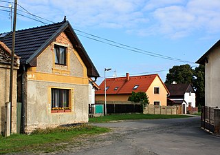
Písková Lhota is a village and municipality in Mladá Boleslav District in the Central Bohemian Region of the Czech Republic. It is located 6 kilometres (3.7 mi) south of Mladá Boleslav and 46 kilometres (29 mi) northeast of Prague.

Kozja is a village in the municipality of Bela Palanka, Serbia. According to the 2002 census, the village has a population of 76 people.

Ćatići is a village in the municipality of Banovići, Bosnia and Herzegovina.
Järise is a village in Lääneranna Parish, Pärnu County, in western Estonia.


