Topolovnik

Last updated
Topolovnik
Тополовник
Village
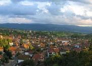
Topolovnik2.jpg
Serbia adm location map.svg
Red pog.svg
Topolovnik
Coordinates: 44°42′N21°26′E / 44.700°N 21.433°E / 44.700; 21.433
CountryFlag of Serbia.svg  Serbia
District Braničevo District
Municipality Veliko Gradište
Population (2002)
  Total 1,098
Time zone CET (UTC+1)
  Summer (DST) CEST (UTC+2)

Topolovnik (Serbian Cyrillic : Тополовник) is a village in the municipality of Veliko Gradište, Serbia. According to the 2002 census, the village has a population of 1098 people. [1]

The Serbian Cyrillic alphabet is an adaptation of the Cyrillic script for the Serbian language, developed in 1818 by Serbian linguist Vuk Karadžić. It is one of the two alphabets used to write standard modern Serbian, Bosnian and Montenegrin, the other being Latin.

Village Small clustered human settlement smaller than a town

A village is a clustered human settlement or community, larger than a hamlet but smaller than a town, with a population ranging from a few hundred to a few thousand. Though villages are often located in rural areas, the term urban village is also applied to certain urban neighborhoods. Villages are normally permanent, with fixed dwellings; however, transient villages can occur. Further, the dwellings of a village are fairly close to one another, not scattered broadly over the landscape, as a dispersed settlement.

Veliko Gradište Town and municipality in Southern and Eastern Serbia, Serbia

Veliko Gradište is a town and municipality located in the Braničevo District of the eastern Serbia. It is situated the right bank of the Danube river and left bank of the Pek river. In 2011, the town has a total population of 6,204, while the municipality has 17,610.

Related Research Articles

Sirig Village in Vojvodina, Serbia

Sirig is a village located in the Temerin municipality, in the South Bačka District of Serbia. It is situated in the Autonomous Province of Vojvodina. The village has a Serb ethnic majority and its population numbering 3,010 people.
Laznica Place in Serbia

Laznica or Lazniţa is a large highland village in Serbia. It is located in the municipality of Žagubica, Braničevo District. The village has a Vlach ethnic majority and its population numbering 2,063 people. Laznica is settled in the north of mountain range of Homolje mountains.

Sokolac, Ljubovija Village in Serbia

Sokolac is a village in Serbia. It is situated in the Ljubovija municipality, in the Mačva District of Central Serbia. The village had a Serb ethnic majority and a population of 104 in 2002.

Podnemić Village in Serbia

Podnemić is a village in Serbia. It is situated in the Ljubovija municipality, in the Mačva District of Central Serbia. The village had an entirely Serbian population of 420 in 2002.

Tornik, Ljubovija Village in Serbia

Tornik is a village in Serbia. It is situated in the Ljubovija municipality, in the Mačva District of Central Serbia. The village had a Serb ethnic majority and a population of 168 in 2002.

Tomanj Village in Serbia

Tomanj is a village in Serbia. It is situated in the Krupanj municipality, in the Mačva District of Central Serbia. The village had a population of 433 in 2002, all of whom were ethnic Serbs.

Arbanaška (Prokuplje) Village in Toplica District, Serbia

Arbanaška is a village in the municipality of Prokuplje, Serbia. According to the 2002 census, the village has a population of 51 people.

Mojković Village in Mačva District, Serbia

Mojković is a village in the municipality of Krupanj, Serbia. According to the 2002 census, the village has a population of 790 people.

Šljivova Village in Mačva District, Serbia

Šljivova is a village in the municipality of Krupanj, Serbia. According to the 2002 census, the village has a population of 849 people.

Gornja Borina Village in Mačva District, Serbia

Gornja Borina is a village in the municipality of Loznica, Serbia. According to the 2002 census, the village has a population of 188 people.

Kamenica (Loznica) Village in Mačva District, Serbia

Kamenica is a village in the municipality of Loznica, Serbia. According to the 2002 census, the village has a population of 189 people.

Veliki Jasenovac Village in Zaječar District, Serbia

Veliki Jasenovac is a village in the municipality of Zaječar, Serbia. According to the 2002 census, the village has a population of 370 people.

Blagojev Kamen Village in Braničevo District, Serbia

Blagojev Kamen is a village in the municipality of Kučevo, Serbia. According to the 2002 census, the village has a population of 38 people.

Brusnica, Gornji Milanovac Village in Moravica District, Serbia

Brusnica is a village in the municipality of Gornji Milanovac, Serbia. According to the 2002 census, the village has a population of 650 people.

Buljesovce is a village in the municipality of Vranje, Serbia. According to the 2002 census, the village has a population of 78 people.

Kobilje, Malo Crniće Village in Braničevo District, Serbia

Kobilje is a village in the municipality of Malo Crniće, Serbia. According to the 2002 census, the village has a population of 930 people.

Granice is a village situated in Mladenovac municipality in Serbia.

Karaula (Prijepolje) Village in Zlatibor District, Serbia

Karaula is a village in the municipality of Prijepolje, Serbia. According to the 2002 census, the village has a population of 63 people.

Izvarica Village in Braničevo District, Serbia

Izvarica is a village in the municipality of Žagubica, Serbia. According to the 2002 census, the village has a population of 376 people.

Slatina (Sopot) Village in Belgrade District, Serbia

Slatina is a village in the municipality of Sopot, Serbia. According to the 2002 census, the village has a population of 254 people.

References

  1. Popis stanovništva, domaćinstava i Stanova 2002. Knjiga 1: Nacionalna ili etnička pripadnost po naseljima. Republika Srbija, Republički zavod za statistiku Beograd 2003. ISBN   86-84433-00-9

Coordinates: 44°42′N21°26′E / 44.700°N 21.433°E / 44.700; 21.433

Geographic coordinate system Coordinate system

A geographic coordinate system is a coordinate system that enables every location on Earth to be specified by a set of numbers, letters or symbols. The coordinates are often chosen such that one of the numbers represents a vertical position and two or three of the numbers represent a horizontal position; alternatively, a geographic position may be expressed in a combined three-dimensional Cartesian vector. A common choice of coordinates is latitude, longitude and elevation. To specify a location on a plane requires a map projection.