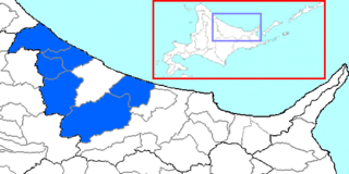
Monbetsu is a district located in Okhotsk Subprefecture, Hokkaido, Japan.

Čepí is a village in the Pardubice Region of the Czech Republic. It has cca 420 inhabitants.
Siodłkowice is a village in the administrative district of Gmina Wołów, within Wołów County, Lower Silesian Voivodeship, in south-western Poland. Prior to 1945 it was in Germany.

Coșbuc is a commune in Bistrița-Năsăud County, Romania. Since the village of Bichigiu was transferred to Telciu commune in 2004, Coșbuc remains the commune's only village.

Cichobórz is a village in the administrative district of Gmina Hrubieszów, within Hrubieszów County, Lublin Voivodeship, in eastern Poland, close to the border with Ukraine. It lies approximately 13 kilometres (8 mi) south-east of Hrubieszów and 115 km (71 mi) south-east of the regional capital Lublin.
Brzeźnica Książęca-Kolonia is a village in the administrative district of Gmina Niedźwiada, within Lubartów County, Lublin Voivodeship, in eastern Poland.
Janopol is a village in the administrative district of Gmina Ożarów, within Opatów County, Świętokrzyskie Voivodeship, in south-central Poland. It lies approximately 4 kilometres (2 mi) north-east of Ożarów, 24 km (15 mi) north-east of Opatów, and 78 km (48 mi) east of the regional capital Kielce.
Rżyska is a village in the administrative district of Gmina Radzymin, within Wołomin County, Masovian Voivodeship, in east-central Poland. It lies approximately 5 kilometres (3 mi) south-east of Radzymin, 5 km (3 mi) north of Wołomin, and 26 km (16 mi) north-east of Warsaw.
Popowo is a village in the administrative district of Gmina Wronki, within Szamotuły County, Greater Poland Voivodeship, in west-central Poland. It lies approximately 5 kilometres (3 mi) west of Wronki, 23 km (14 mi) north-west of Szamotuły, and 54 km (34 mi) north-west of the regional capital Poznań.
Dobrzewino is a village in the administrative district of Gmina Szemud, within Wejherowo County, Pomeranian Voivodeship, in northern Poland. It lies approximately 12 kilometres (7 mi) east of Szemud, 19 km (12 mi) south-east of Wejherowo, and 19 km (12 mi) north-west of the regional capital Gdańsk.
Bądy is a village in the administrative district of Gmina Pasłęk, within Elbląg County, Warmian-Masurian Voivodeship, in northern Poland. It lies approximately 10 kilometres (6 mi) north of Pasłęk, 21 km (13 mi) east of Elbląg, and 64 km (40 mi) north-west of the regional capital Olsztyn.
Żydowo is a village in the administrative district of Gmina Polanów, within Koszalin County, West Pomeranian Voivodeship, in north-western Poland. It lies approximately 7 kilometres (4 mi) south of Polanów, 39 km (24 mi) south-east of Koszalin, and 157 km (98 mi) north-east of the regional capital Szczecin.
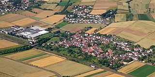
Wenkbach is a village in Hesse, Germany and part of the municipality of Weimar (Lahn). It is situated 10 km south of Marburg and 20 km north of Gießen. Wenkbach has about 680 inhabitants.

Gornji Striževac is a village in the municipality of Babušnica, Serbia. According to the 2002 census, the village has a population of 154 people.
Vrbica is a village in the municipality of Zaječar, Serbia. According to the 2002 census, the village has a population of 313 people.
Velika Vrbica is a village in the municipality of Kladovo, Serbia. According to the 2002 census, the village has a population of 996 people.

Konjevići is a village in the municipality of Kladanj, Bosnia and Herzegovina.
Božurevac is a village in the municipality of Trstenik, Serbia. According to the 2002 census, the village has a population of 311 people.

Chinle Creek is a tributary stream of the San Juan River in Apache County, Arizona and San Juan County, Utah. Its source is at 36°53′40″N109°44′37″W, the confluence of Laguña Creek with Chinle Wash where it forms Chinle Creek, 7 miles northeast of Dennehotso, Arizona at an elevation of 4,774 feet (1,455 m). Its mouth is at its confluence with the San Juan River at 37°11′53″N109°42′57″W at an elevation of 4,229 feet (1,289 m), 9 miles northeast of Mexican Hat, Utah.
Deliçay is a creek in Mersin Province, Turkey. The name refers to its highly irregular flowrate.


