Devale, Mawal

Last updated

Devale
Village
India Maharashtra location map.svg
Red pog.svg
Devale
Location in Maharashtra, India
India location map.svg
Red pog.svg
Devale
Devale (India)
Coordinates: 19°18′24″N73°10′46″E / 19.3067526°N 73.1795815°E / 19.3067526; 73.1795815 Coordinates: 19°18′24″N73°10′46″E / 19.3067526°N 73.1795815°E / 19.3067526; 73.1795815
CountryFlag of India.svg  India
State Maharashtra
District Pune
Tehsil Mawal
Government
  Type Panchayati raj (India)
  Body Gram panchayat
Population
  Total1,358
  Sex ratio 701/657 /
Languages
  Official Marathi
  Other spoken Hindi
Time zone UTC+5:30 (IST)
Pin code
410405
Telephone code 02114
ISO 3166 code IN-MH
Vehicle registration MH-14
Website pune.nic.in

Devale is a village in India, situated in Mawal taluka of Pune district in the state of Maharashtra. [1]

Mawal taluka Tehsil in Maharashtra, India

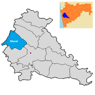
Mawal taluka is a taluka in Mawal subdivision of Pune district of state of Maharashtra in India. The area's name is also spelled as Maval.

Pune is a district in the state of Maharashtra, India. Pune City Central is the District Headquarters. The district's population was 9,426,959 in the 2011 census, the fourth-most-populous of India's 640 districts. Its urban population is 58.08 percent of its total population; the population of the Pune urban area is over five million.

Maharashtra State in western India

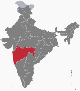
Maharashtra is a state in the western peninsular region of India occupying a substantial portion of the Deccan plateau. It is the second-most populous state and third-largest state by area in India. Spread over 307,713 km2 (118,809 sq mi), it is bordered by the Arabian Sea to the west, the Indian states of Karnataka and Goa to the south, Telangana and Chhattisgarh to the east, Gujarat and Madhya Pradesh to the north, and the Indian union territory of Dadra and Nagar Haveli to the north west. It is also the world's second-most populous subnational entity. It was formed by merging the western and south-western parts of the Bombay State, Berar and Vidarbha, and the north-western parts of the Hyderabad State and splitting Saurashtra by the States Reorganisation Act. It has over 112 million inhabitants and its capital, Mumbai, has a population around 18 million making it the most populous urban area in India. Nagpur hosts the winter session of the state legislature. Pune is known as the 'Oxford of the East' due to the presence of several well-known educational institutions. Nashik is known as the 'Wine Capital of India' as it has the largest number of wineries and vineyards in the country.

Contents

Administration

The village is administrated by a Sarpanch, who is an elected representative.

The term administration, as used in the context of government, differs according to jurisdiction.

A sarpanch is elected by the village-level constitutional body of local self-government called the Gram Sabha in India. The sarpanch, together with other elected pancha (members), constitute the gram panchayat. The sarpanch is the focal point of contact between government officers and the village community.

Demographics

At the 2011 Census of India, the village comprised 257 households. The population of 1358 was split between 701 males and 657 females. [1]

The 15th Indian Census was conducted in two phases, house listing and population enumeration. House listing phase began on 1 April 2010 and involved collection of information about all buildings. Information for National Population Register(NPR)was also collected in the first phase, which will be used to issue a 12-digit unique identification number to all registered Indian residents by Unique Identification Authority of India (UIDAI). The second population enumeration phase was conducted between 9 and 28 February 2011. Census has been conducted in India since 1872 and 2011 marks the first time biometric information was collected. According to the provisional reports released on 31 March 2011, the Indian population increased to 1.21 billion with a decadal growth of 17.70%. Adult literacy rate increased to 74.04% with a decadal growth of 9.21%. The motto of the census was 'Our Census, Our future'.

See also

Related Research Articles

Devghar Village in Maharashtra, India

Devghar is a village in India, situated in Mawal taluka of Pune district in the state of Maharashtra.

Dhamane Village in Maharashtra, India

Dhamane is a village in India, situated in Mawal taluka of Pune district in the state of Maharashtra.

Dhangavhan Village in Maharashtra, India

Dhangavhan is a village in India, situated in Mawal taluka of Pune district in the state of Maharashtra.

Divad Village in Maharashtra, India

Divad is a village in India, situated in Mawal taluka of Pune district in the state of Maharashtra.

Brahmanoli Village in Maharashtra, India

Brahmanoli is a village in India, situated in Mawal taluka of Pune district in the state of Maharashtra.

Gahunje Village in Maharashtra, India

Gahunje is a village in India, situated in Mawal taluka of Pune district in the state of Maharashtra.

Ghonshet Village in Maharashtra, India

Ghonshet is a village in India, situated in Mawal taluka of Pune district in the state of Maharashtra.

Jambhavali Village in Maharashtra, India

Jambhavali is a village in India, situated in Mawal taluka of Pune district in the state of Maharashtra.

Jambhul Village in Maharashtra, India

Jambhul is a village in India, situated in Mawal taluka of Pune district in the state of Maharashtra.

Jovan, Mawal Village in Maharashtra, India

Jovan is a village in India, situated in Mawal taluka of Pune district in the state of Maharashtra.

Kacharewadi Village in Maharashtra, India

Kacharewadi is a village in India, situated in Mawal taluka of Pune district in the state of Maharashtra.

Kadav Village in Maharashtra, India

Kadav is a village in India, situated in Mawal taluka of Pune district in the state of Maharashtra.

Kambare Andar Mawal Village in Maharashtra, India

Kambare Andar Mawal is a village in India, situated in Mawal taluka of Pune district in the state of Maharashtra.

Khandashi Village in Maharashtra, India

Khandashi is a village in India, situated in Mawal taluka of Pune district in the state of Maharashtra.

Kusavali Village in Maharashtra, India

Kusavali is a village in India, situated in Mawal taluka of Pune district in the state of Maharashtra.

Malewadi Village in Maharashtra, India

Malewadi is a village in India, situated in Mawal taluka of Pune district in the state of Maharashtra.

Nane, Mawal Village in Maharashtra, India

Nane is a village in India, situated in Mawal taluka of Pune district in the state of Maharashtra.

Sadapur Village in Maharashtra, India

Sadapur is a village in India, situated in the Mawal taluka of Pune district in the state of Maharashtra.

Sangavi is a village in India, situated in the Mawal taluka of Pune district in the state of Maharashtra.

References

  1. 1 2 "Census of India 2011: Maharashtra: District Census Handbook: Pune" (PDF). Directorate of Census Operations. p. 408. Archived from the original (PDF) on 11 March 2016. Retrieved 19 May 2019.