Related Research Articles

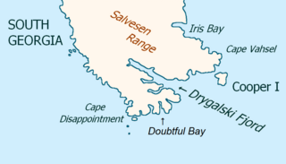
Drygalski Fjord is a bay 1 mile (1.6 km) wide which recedes northwestwards 7 miles (11 km), entered immediately north of Nattriss Head along the southeast coast of South Georgia. It was charted by the Second German Antarctic Expedition, 1911–12, under Wilhelm Filchner, and named for Professor Erich von Drygalski, the leader of the First German Antarctica Expedition, 1901–03.
Goldcrest Point is the northwest point of Bird Island, South Georgia, with Payne Creek just south of it. It was charted by Discovery Investigations personnel on the Discovery in the period 1926–30 and by the South Georgia Survey, 1951–57. The point is the site of a large colony of Macaroni penguins. The name, given by the UK Antarctic Place-Names Committee in 1963, refers to the golden crests of this species.
Gony Point is a high tussock-covered point 0.5 miles (0.8 km) southwest of Cardno Point, on the southeast side of Bird Island, South Georgia. It was surveyed by the South Georgia Survey in the period 1951–57, and named by the UK Antarctic Place-Names Committee in 1963. Gony is an old sailors' name for the wandering albatross, which breeds on Bird Island.
Jomfruene is a group of three small tussock-covered islands and a number of barren rocks, lying 1 nautical mile (2 km) west-northwest of Cape Paryadin, South Georgia. The position and number of these islands have been approximated on charts for years. In 1951–52, the South Georgia Survey (SGS) reported that the single large island, shown on charts as "Three Point Island," was known locally as Jomfruene. Following more detailed survey by the SGS, 1955–56, it is now known that there are three small islands, not one large one, and the local name has been extended to the group.
Cape Alexandra is a cape which forms the northwest extremity of South Georgia. It was named "Cape North" in 1775 by a British expedition under James Cook, but this name has since become established for a cape 10 nautical miles (20 km) east-northeast which forms the northernmost point of South Georgia. The name Cape Alexandra dates back to about 1912 and commemorates Queen Alexandra, Consort of King Edward VII of the United Kingdom.
The Andrews Rocks are a small group of rocks 0.5 nautical miles (1 km) east of Cape Paryadin, South Georgia. The rocks are bare of vegetation and awash in heavy seas. The name "Andrews Islands" was probably given by Lieutenant Commander J.M. Chaplin, Royal Navy, of the RRS Discovery during his survey of the area in 1926. The South Georgia Survey, 1955–56, reported that "rocks" is a more suitable descriptive term for this group.
Cardno Point is a high flat-topped, tussock-covered headland forming the eastern extremity of Bird Island, off the west end of South Georgia. It was named by the UK Antarctic Place-Names Committee for Lieutenant Commander Peter G.N. Cardno, Royal Navy, navigating officer of HMS Owen, which made a hydrographic survey of the area in 1960–61.
Cook Bay is an irregular bay, 1.3 nautical miles (2.4 km) wide at its entrance between Cape Crewe and Black Head, narrowing into two western arms, Lighthouse Bay and Prince Olav Harbour, along the north coast of South Georgia. It was charted by Discovery Investigations (DI) personnel during the period 1926–30, and named by them for Captain James Cook, who explored South Georgia and landed in this general vicinity in 1775.
Wanderer Valley is a valley in central Bird Island, South Georgia. The valley extends northeast for 0.5 nautical miles (0.9 km) from the head of Freshwater Inlet. It was named by the United Kingdom Antarctic Place-Names Committee (UK-APC) after the wandering albatross whose principal breeding grounds are nearby.
Weddell Point is a low, tussock-covered point forming the east side of the entrance to Schlieper Bay, on the south coast and near the west end of South Georgia. The name Cape Weddell was given by David Ferguson, Scottish geologist, during his visit to South Georgia in 1911–12. Named after James Weddell, Master, Royal Navy, who visited South Georgia in 1823. Point is considered a more suitable descriptive term for this feature than cape.
The Cordall Stacks are two conspicuous rock stacks, the eastern one joined to Bird Island, South Georgia, by a low isthmus, lying on the northwest side of the island 0.3 nautical miles (0.6 km) northwest of Jordan Cove. They were named by the UK Antarctic Place-Names Committee for Peter A. Cordall, a member of the South Georgia Biological Expedition, 1958–59, who made a plane table survey of Bird Island.
Jordan Cove is a small cove which is the principal indentation in the south side of Bird Island, off the west end of South Georgia, near Antarctica.
Dixon Peak is a steep-sided peak rising to 420 metres (1,380 ft) at the southern end of Paryadin Ridge, 1 nautical mile (2 km) north of Cape Paryadin, South Georgia. It was roughly charted by Discovery Investigations personnel on the Discovery in the period 1926–30, and was named by the UK Antarctic Place-Names Committee in 1963 for Lieutenant John B. Dixon, Royal Navy, surveying officer on HMS Owen, which surveyed the area in 1960–61.
Greene Inlet is an inlet immediately northwest of Cape Paryadin at the west end of South Georgia. The name "Deep Inlet" was probably given by Lieutenant Commander J.M. Chaplin, Royal Navy, of the Discovery, during his survey of the Undine Harbour area in 1926 but it is not used locally. The South Georgia Survey, 1951–52, reported that the feature requires a name, but that Deep Inlet is not sufficiently distinctive, being descriptive of so many features at South Georgia. Greene Inlet is named for Daniel Greene of New Haven, CT, who in 1790 commanded one of the first two American sealing vessels to visit South Georgia.
Fantome Rock is a dangerous rock in the middle of Bird Sound, South Georgia, lying 0.1 nautical miles (0.2 km) south of Gony Point, Bird Island. It was charted by Discovery Investigations personnel on the Discovery in the period 1926–30 and named by the UK Antarctic Place-Names Committee in 1963 for HMS Owen's motor cutter, used in a survey of this area in February–March 1961, and lost in heavy seas near this rock.
Farewell Point is a point which forms the northeast extremity of Bird Island, off the west end of South Georgia. The name appears to have been applied by Discovery Investigations personnel who charted South Georgia in the period 1926–30.
Paryadin Ridge is a ridge extending from Cape Alexandra to Cape Paryadin at the west end of South Georgia. The name "Paryadin-Kamm," derived from nearby Cape Paryadin, was given by Ludwig Kohl-Larsen during his visit to South Georgia in 1928–29. An English form of the name has been approved.
Freshwater Inlet is the small eastern arm of Jordan Cove on the south side of Bird Island, South Georgia, with Wanderer Valley to the southwest. It was charted by the South Georgia Survey in the period 1951–57 and was named in 1956 by W.N. Bonner, a British government biologist and sealing inspector, because the feature is fed by freshwater streams.
Gazella Peak is a peak rising over 120 metres (390 ft) between Roche Peak and the Cordall Stacks on the north side of Bird Island, South Georgia. It was charted by the South Georgia Survey in the period 1951–57, and was named by the UK Antarctic Place-Names Committee in 1963 after the species name of the Antarctic fur seal, which breeds in considerable numbers on Bird Island.
References
- ↑ "Diver Point". Geographic Names Information System . United States Geological Survey, United States Department of the Interior . Retrieved 21 January 2012.
![]() This article incorporates public domain material from "Diver Point". Geographic Names Information System . United States Geological Survey.
This article incorporates public domain material from "Diver Point". Geographic Names Information System . United States Geological Survey.
Capital: King Edward Point | |||||||
| General | |||||||
| Settlements / Whaling stations | |||||||
| South Georgia islands | |||||||
| South Sandwich Islands |
| ||||||
| Seamounts | |||||||
| Landmarks |
| ||||||
| | This South Georgia and the South Sandwich Islands location article is a stub. You can help Wikipedia by expanding it. |