
The Burke and Wills expedition was organised by the Royal Society of Victoria in Australia in 1860–61. It consisted of 19 men led by Robert O'Hara Burke and William John Wills, with the objective of crossing Australia from Melbourne in the south, to the Gulf of Carpentaria in the north, a distance of around 3,250 kilometres. At that time most of the inland of Australia had not been explored by non-Indigenous people and was largely unknown to the European settlers.
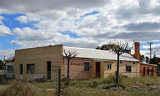
Menindee, frequently but erroneously spelled "Menindie", is a small town in the far west of New South Wales, Australia, in Central Darling Shire, on the banks of the Darling River, with a sign-posted population of 980 and a 2016 census population of 551.

General Sir Richard Bourke, KCB, was an Irish-born British Army officer who served as Governor of New South Wales from 1831 to 1837. As a lifelong Whig (Liberal), he encouraged the emancipation of convicts and helped bring forward the ending of penal transportation to Australia. In this, he faced strong opposition from the military/conservative establishment and its press. He approved a new settlement on the Yarra River, and named it Melbourne, in honour of the incumbent British prime minister, Lord Melbourne.

The Division of Gellibrand is an Australian Electoral Division in Victoria. The division was created in 1949 and is named after Joseph Gellibrand, a pioneer settler of the Melbourne area. It is located in the industrial inner western suburbs of Melbourne and includes Altona, Kingsville, Laverton, Newport, Seabrook, Seaholme, Seddon, South Kingsville, Spotswood, Williamstown, Williamstown North and Yarraville; and parts of Brooklyn, Footscray, Laverton North, Point Cook, West Footscray and Williams Landing.
The Division of Bourke was an Australian electoral division in Victoria. The division was proclaimed in 1900, and was one of the original 65 divisions to be contested at the first federal election. It was abolished in 1949. It was named for Sir Richard Bourke, who was Governor of New South Wales at the time of the founding of Melbourne. It was based in the northern suburbs of Melbourne, including the suburbs of Brunswick and Coburg. After 1910, it was a safe seat for the Australian Labor Party, but was lost to an independent Labor member in 1946.
The Division of Burke was an Australian Electoral Division in Victoria. The division was created in 1969 and abolished in 2004.
The Division of Gwydir was an Australian electoral division in the state of New South Wales. The division was proclaimed in 1900, and was one of the original 65 divisions to be contested at the first federal election. As a result of the electoral redistribution of 13 September 2006, Gwydir was abolished and ceased to exist at the 2007 federal election.

The Division of Gorton is an Australian Electoral Division in the state of Victoria.

The Division of Parkes is an Australian electoral division in the state of New South Wales. The largest electorate in the state, it is located in the far north west of the state, adjoining the border with Queensland in the north and with South Australia in the west. The division is named after Sir Henry Parkes, seventh Premier of New South Wales and sometimes known as the 'Father of Federation'. The division was proclaimed at the redistribution of 11 October 1984, and was first contested at the 1984 federal election.
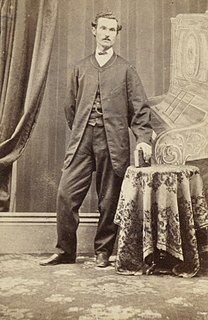
John King was an Irish soldier who achieved fame as an Australian explorer. He was the sole survivor of the four men from the ill-fated Burke and Wills expedition who reached the Gulf of Carpentaria. The expedition was the first to cross Australia from south to north, finding a route across the continent from Melbourne in Victoria to the Gulf of Carpentaria in Queensland.

Innamincka, formerly Hopetoun, is a town and locality in north-east South Australia, with a population of 44 people. It is 821 kilometres north-east of Adelaide and 365 kilometres north-east from the closest town, Lyndhurst. It is also 66 kilometres north-east of the Moomba Gas Refinery. The town lies within the Innamincka Regional Reserve and is surrounded by the Strzlecki Desert to the south and the Sturt Stony Desert to the north. The township is situated along the Cooper Creek, a part of the Lake Eyre Basin.

Melbourne City Centre is an area of Melbourne, Victoria, Australia. It is the area in which Melbourne was established in 1835, by John Batman and John Pascoe Fawkner, and its boundaries are defined by the Government of Victoria's Melbourne Planning Scheme. Today it comprises the two oldest areas of Melbourne; the Hoddle Grid and Queen Victoria Market, as well as sections of the redeveloped areas of Docklands and Southbank/South Wharf. It is not to be confused with the larger local government area of the City of Melbourne.
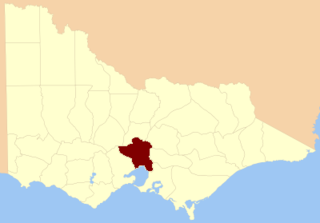
The County of Bourke is one of the 37 counties of Victoria which are part of the Lands administrative divisions of Australia, used for land titles. It is the oldest and most populous county in Victoria and contains the city of Melbourne. Like other counties in Victoria, it is subdivided into parishes. The county was named after General Sir Richard Bourke, the Governor of New South Wales between 1831 and 1837. It is bordered by the Werribee River in the west, the Great Dividing Range in the north, Port Phillip in the south, and by Dandenong Creek, a small part of the Yarra River, and the Plenty River in the east. The county was proclaimed in 1853.
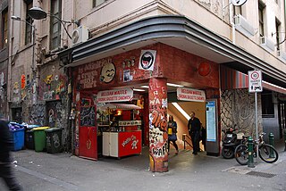
The lanes and arcades of Melbourne, Australia, have collectively become culturally important.

Members of the Victorian Legislative Council, the upper house of the Parliament of the Australian State of Victoria, are elected from eight multi-member electorates called regions. The Legislative Council has 40 members, five from each of the eight regions.

The Electoral district of South Bourke was an electoral district of the Legislative Assembly in then Australian colony of Victoria. It was one of the original 36 electoral districts of the Assembly. It covered an area east of Melbourne, bounded by Dandenong Creek in the south and east, Moorabbin, Prahran and Hawthorn in the west and Templestowe in the north. It was abolished in 1889.


