Donacarney

Last updated

Donacarney
Domhnach Cairnigh Mór
Town
Castle at Donacarney, Co. Meath - geograph.org.uk - 1063617.jpg
Castle ruin at Donacarney
Ireland adm location map.svg
Red pog.svg
Donacarney
Location in Ireland
Coordinates: 53°42′34″N6°16′42″W / 53.70944°N 6.27833°W / 53.70944; -6.27833
CountryIreland
Province Leinster
County County Meath
Area
  Total2.19 km2 (0.85 sq mi)

Donacarney (Irish : Domhnach Cearnaigh or Domhnach Cairnigh) is a village in County Meath, [1] Ireland, close to Drogheda and the border with County Louth. It contains one church, two estates, two schools, and one pub.[ citation needed ] Although it includes the townlands of Donacarney Great and Donacarney Little, most locals would never use those terms in describing Donacarney. The remains of a late-medieval tower house (see picture to right) are sited close to Donacarney Cross. It is described in the Down Survey (1654–56)as "an ould Castle". It appears in this state on a map of 1771. Blackhills Crescent, Donacarney, takes its name from the area known as the Black Hills or Black Hill Lands [2] north of the crossroads and the castle, the old name of which was Croc a' Searra in Irish.

Contents

For census purposes, Donacarney is combined with a number of other local towns to form the census town of Laytown–Bettystown–Mornington–Donacarney, with a total population of 11,872 at the 2016 census. [3]

Schools

Donacarney has two schools: a boys' school and a girls' school. Roughly 600 pupils attend both schools. The schools share the same campus. The names of the schools are Réalt ná Mara BNS and Réalt ná Mara GNS respectively. [4] The old school hall, which was replaced by the current schools in 1965, was originally opened in 1873. The red-bricked building, beside the forge and old village water pump at Donacarney Cross, now serves as a community centre. It is also used as the local polling centre in elections. The school was given planning permission for a new school in 2012.[ needs update ]

Religion

There is one Roman Catholic church close to Donacarney in the adjoining townland of Mornington. It is called Star of the Sea Church. It is also called Mornington Church, and serves the half-parish of Mornington, part of the Laytown-Mornington parish created in 1986, which includes Donacarney.

History

Donacarney, or Duuenacharny, was recorded as part of Mornington in a 'Charter of Walter de Lacy reciting and confirming a grant made by Hugh his father of various churches & lands in Ireland’ in 1230–1234. [5] [6] Thereafter [7] it became part of the manor of Colpe throughout the medieval period. It was in the possession of the Augustinian Abbey at Colp, (a cell of Llanthony Priory in Monmouthshire) but held and run separate from the manor by a tenant. [8] At the Suppression of the Monasteries in 1536 in became part of the estates of Henry Draycott. The ruins of the late-medieval tower house were known as ‘Draycott’s Castle’ and is thought to have been burnt in 1641. [9]

Little Donacarney was connected to the eighteenth-century case of Annesley v Earl of Anglesea [sic.] (1743). This case was taken to trial to test the claim of James Annesley to the title and estates of Earl of Anglesey as the legitimate son and heir of Arthur, lord Altham against the claims of his uncle Richard Annesley, 6th Earl of Anglesey. The trial was commenced in November 1743 by a plea of trespass and ejectment taken against the Richard, Earl of Angelsey for 1,500 acres of the lands of Great and Little Stameen, Little Donacarney, Shallon &c. in the County of Meath, by Campbell Craig for those lands leased to him in May 1742 to him by James Annesley, Esq. and which Craig occupied and was subsequently ejected from in May 1742. This allowed the question of ownership of the estates of the Earl of Anglesey to be raised in the Irish courts. James laid claim to his birthright with the help of the Scottish adventurer and barrister Daniel Mackercher. It has been claimed that the novel Kidnapped by Robert Louis Stevenson was inspired by the true story of James Annesley's sale into servitude in America and return to claim his inheritance.

In 1799 a local respectable farmer named Laurence Murray was robbed by banditti who surrounded the house and broke open the door. They declared "We are not robbers, but patriots; and it is but just that the opulent should contribute to support us, who thus venture ours lives for the good of the country". They left with cash, a sugar tongs and a Great Coat, before their captain returned what teaspoons they had taken. [10]

Related Research Articles

<span class="mw-page-title-main">Drogheda</span> Town in County Louth, Ireland, with suburbs in County Meath

Drogheda is an industrial and port town in County Louth on the east coast of Ireland, 56 km (35 mi) north of Dublin. It is located on the Dublin–Belfast corridor on the east coast of Ireland, mostly in County Louth but with the south fringes of the town in County Meath, 49 km (30 mi) north of Dublin. Drogheda had a population of 44,135 inhabitants in 2022, making it the eleventh largest settlement by population in all of Ireland, and the largest town in the Republic of Ireland by both population and area. It is the last bridging point on the River Boyne before it enters the Irish Sea. The UNESCO World Heritage Site of Newgrange is located 8 km (5.0 mi) west of the town.

<span class="mw-page-title-main">River Boyne</span> River in Leinster, Ireland

The River Boyne is a river in Leinster, Ireland, the course of which is about 112 kilometres (70 mi) long. It rises at Trinity Well, Newberry Hall, near Carbury, County Kildare, and flows towards the Northeast through County Meath to reach the Irish Sea between Mornington, County Meath, and Baltray, County Louth.

<span class="mw-page-title-main">County Meath</span> County in Ireland

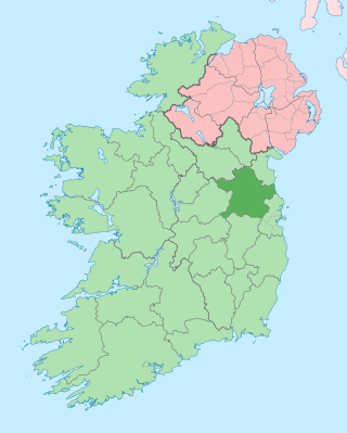
County Meath is a county in the Eastern and Midland Region of Ireland, within the province of Leinster. It is bordered by County Dublin to the southeast, Louth to the northeast, Kildare to the south, Offaly to the southwest, Westmeath to the west, Cavan to the northwest, and Monaghan to the north. To the east, Meath also borders the Irish Sea along a narrow strip between the rivers Boyne and Delvin, giving it the second shortest coastline of any county. Meath County Council is the local authority for the county.

<span class="mw-page-title-main">Julianstown</span> Village in Leinster, Ireland

Julianstown is a village in County Meath, Ireland. It is located near Drogheda on the R132 regional road. In 1641, the Battle of Julianstown was fought here during the Irish Rebellion of 1641.

<span class="mw-page-title-main">Ardcath</span> Village in Leinster, Ireland

Ardcath is a small village in County Meath, Ireland. The surrounding villages include Garristown, Clonalvy, Duleek, Battramstown, Bellewstown and Stamullen.

<span class="mw-page-title-main">Laytown</span> Village in Leinster, Ireland

Laytown is a village in County Meath, Ireland, located on the R150 regional road and overlooking the Irish Sea. Historically it was called Ninch, after the townland it occupies. Together with the neighbouring villages of Mornington and Bettystown it comprises the census town of Laytown-Bettystown-Mornington with a combined population of 10,889 at the 2011 census, which is part of the wider area collectively known as East Meath. The 2016 census recorded a population of 11,872 in the area which is now called Laytown-Bettystown-Mornington-Donacarney.

<span class="mw-page-title-main">Donaghmore, County Tyrone</span> Place

Donaghmore is a village, townland and civil parish in County Tyrone, Northern Ireland, about five kilometres (3 mi) north-west of Dungannon. In the 2011 Census it had a population of 1,122 people. The village is beside the River Torrent, formerly known as the Torrent Flow.

<span class="mw-page-title-main">Cusack</span> Family name

Cusack is an Irish family name of Norman origin Cussacq, originally from Cussac in Guienne (Aquitaine), France. The surname has diminished in common use in England, but is still common in Ireland, where it was introduced during the Norman invasion of Ireland in the 12th century.

Athboy is a small agricultural town located in County Meath. The town is located on the Yellow Ford River, in wooded country near the County Westmeath border. Local Clubs are Clann Na nGael and Athboy Celtic.

<span class="mw-page-title-main">Roman Catholic Diocese of Meath</span> Catholic diocese in Ireland

The Diocese of Meath is a diocese of the Catholic Church that is located in the middle part of Ireland. It is one of eight suffragan dioceses of the ecclesiastical province of Armagh. Thomas Deenihan has been bishop of the diocese since 2 September 2018.

<span class="mw-page-title-main">Bettystown</span> Village in County Meath, Ireland

Bettystown, previously known as Betaghstown and transliterated to Beattystown/Bettystown, is a village in County Meath, Ireland. Together with the neighbouring villages of Laytown and Mornington it comprises the census town of Laytown-Bettystown-Mornington with a combined population of 10,889 at the 2011 census and 11,872 at the 2016 census. During the Celtic Tiger, with increasing property prices in Dublin, Bettystown expanded to cater for large numbers of commuters to Dublin. The area was well known before that as a spot for Dublin summer holiday visitors, with a number of caravan parks and seaside amusements.

<span class="mw-page-title-main">Mornington, County Meath</span> Village in Leinster, Ireland

Mornington is a coastal village on the estuary of the River Boyne in County Meath, Ireland approximately 5 km downriver from the centre of Drogheda. Together with the neighbouring villages of Laytown and Bettystown it comprises the census town of Laytown-Bettystown-Mornington, with a combined population of 10,889 at the 2011 census and 11,872 at the 2016 census. Mornington is part of the wider area collectively known as East Meath.

<span class="mw-page-title-main">Laytown–Bettystown–Mornington–Donacarney</span> Built-up area in County Meath, Ireland

Laytown–Bettystown–Mornington–Donacarney is a built up area in East Meath, County Meath, Ireland, comprising the adjoining villages of Laytown, Bettystown, Mornington and Donacarney. Prior to 2016, it was listed as Laytown–Bettystown–Mornington.

<span class="mw-page-title-main">Donaghpatrick</span>

Donaghpatrick is a village and townland in County Meath, Ireland. It lies approximately 5 km northwest of Navan off the R147 regional road between Navan and Kells on the northern bank of the River Blackwater. The Irish language name of the townland, Domhnach Phádraig, means "the church of Patrick". The local Church of Ireland church, dedicated to Saint Patrick, was built in 1896 close to the site of a much earlier church, and incorporating parts of a medieval tower house.

<span class="mw-page-title-main">Mullanacre Lower</span>

Mullanacre Lower is a townland in the Parish of Tomregan, Barony of Tullyhaw, County Cavan, Ireland.

Henry Draycott was an English-born Crown official and judge in sixteenth-century Ireland, who held a number of senior Government offices, including Chancellor of the Exchequer of Ireland. Despite his apparent lack of legal qualifications, he also had a successful career as a judge, becoming a Baron of the Court of Exchequer (Ireland) and Master of the Rolls in Ireland. He became a substantial landowner in the Pale, with his principal estate at Mornington, County Meath.

<span class="mw-page-title-main">Erraran</span> Townland in the civil parish of Templeport, County Cavan, Ireland

Erraran (from Irish: Airearan, meaning 'Land bordering a Lake' is a townland in the civil parish of Templeport, County Cavan, Ireland. It lies in the Roman Catholic parish of Templeport and barony of Tullyhaw.

<span class="mw-page-title-main">Borim (Kinawley)</span> Townland in County Cavan, Ireland

Borim is a townland in the civil parish of Kinawley, barony of Tullyhaw, County Cavan, Ireland. A sub-division is called The Knocken. The 1938 Dúchas collection states- it is a field in the farm of Mr Patrick McGovern. It is a high bank over a river with a lone bush growing in it.

<span class="mw-page-title-main">Augherskea</span> Townland in County Meath, Ireland

Augherskea is a townland in the civil parish of Knockmark, barony of Lower Deece, County Meath, Ireland.

Coláiste na hInse colloquially referred to by locals as The Coláiste, is a co-educational secondary school in Bettystown, County Meath, Ireland. Whilst English is the Coláiste's primary language of instruction, it places an emphasis on the use of Irish on a day to day basis.

References

  1. "Domhnach Cairnigh Mór". logainm.ie. Archived from the original on 3 June 2012. Retrieved 2 August 2010.
  2. "Advert". Drogheda Conservative. 31 January 1885. p. 4.
  3. "Sapmap Area – Settlements: Laytown-Bettystown-Mornington-Donacarney". Census 2016. Central Statistics Office. April 2016.
  4. "Reált Na Mara Girls National School".
  5. LXVIII Carta eiusdem Walteri de omnibus beneficiis et terries in Midia. Irish Cartularies of Llanthony Prima & Secunda:83
  6. Arlene Hogan, The priory of Llanthony Prima and Secunda in Ireland, 1172–1541: Lands, patronage and politics, (Dublin, 2008), p. 158
  7. Swift, Catherine (2004). "St. Patrick, Skerries and the earliest evidence for local church organization in Ireland". In MacShamhráin, Ailbhe (ed.). The Island of St. Patrick. Dublin. p. 69. ISBN   1-85182-867-2.{{cite book}}: CS1 maint: location missing publisher (link)
  8. Kevin Whelan, 'Towns and villages', p.182, "Fig. 5, Colp manor in the fifteenth century" in F.H.A. Aalen (ed.), Atlas of the Irish rural landscape, (Cork, 1997)
  9. Irish Tourist Association survey, relating to ‘Natural features, antiquities, historic associations etc.', 1942. Extract copied into the Topographical files of the Office of Public Works then incorporated into the Sites and Monuments Record files (National Monuments Service) referenced http://www.archaeology.ie
  10. Page 3, Freeman's Journal, 15 January 1799.