Durrow is a small rural village and townland in County Offaly, Ireland. Durrow is located on the N52 off the N6 road between Kilbeggan and Tullamore.

Ballintra is a village in the parish of Drumholm in the south of County Donegal, Ireland, just off the N15 road between Donegal town and Ballyshannon. Ballintra lies on the northern bank of the Blackwater river. The river rises in the hills that lie inland from the town, and flows through a number of small lakes before spilling over a small waterfall in a gorge behind the village.

Mary Josephine Lavin wrote short stories and novels. An Irishwoman, she is now regarded as a pioneer in the field of women's writing. The well-known Irish writer Lord Dunsany mentored Lavin after her father approached him on her behalf to discuss with him some stories she had written.

Easky or Easkey is a village in County Sligo, Ireland. It is on the Atlantic coast, 26 miles (42 km) from Sligo and 15 miles (24 km) from Ballina, County Mayo. The village name derives from the Irish language term for fish ("iasc") and "Iascaigh" literally means "abounding in fish", due to the Easky River that lies adjacent to the village itself. Easky, as a parish, was originally called "Imleach Iseal". The area is a tourist destination on account of its scenery and water sports. Easky is a designated area on Ireland's Wild Atlantic Way tourist route.

Bonniconlon, officially Bunnyconnellan, is a village in the barony of Gallen in north County Mayo, Ireland. The village is on the R294 regional road to the east of Ballina, County Mayo, and close to the Ox Mountains.

Caragh or Carragh is a village in County Kildare, Ireland. It is located on the R409 regional road between the River Liffey and the Grand Canal and is located 6.1 km north-west of Naas. The village is also 7.9 km from Clane and 10.6 km from Newbridge.

Tullyallen is a village, civil parish and townland 6 km north-west of the town of Drogheda in County Louth, Ireland. It is in the historic Barony of Ferrard. It is located in the historical Boyne Valley, in the Catholic parish of Mellifont ; it is also close to Newgrange, Knowth and Dowth burial mounds, Monasterboice monastery, and to the Battle of the Boyne site.

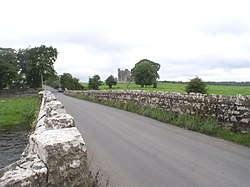
Bective Abbey is a Cistercian abbey on the River Boyne in Bective, County Meath, Ireland.

Knockbridge is a village in County Louth, Ireland. It is located in the townland of Ballinlough in the historical barony of Dundalk Upper. As of the 2016 census, the village had a population of 667 people. Knockbridge won a "best kept village" award in the 2008 Tidy Towns competition.

Haggardstown is a townland and a civil parish located on the outskirts of Dundalk, County Louth, Ireland. The civil parish of Haggardstown lies on the shore of Dundalk Bay, north of the estuary of the River Fane, and includes the village of Blackrock.

Drumone is a small village and townland in western County Meath, Ireland.
Mulhussey is a townland and village in County Meath, Ireland. It has a school, a castle with accompanying cemetery, a nearby church at the edge of the Kilcloon parish in Kilcock, and a religious antiquity, St Bridgid's Well, located in Calgath near Mulhussey.
Ballyhide is a rural townland and village in the extreme south eastern corner of County Laois, Ireland at the border with County Carlow. The nearest urban centre is Carlow town which is 3 kilometres to the north east. It is located in the Luggacurren Local Electoral District.

Stonetown is a small rural community spanning the townlands of Stonetown Upper and Stonetown Lower in County Louth. It lies in the parish of Louth, 10 kilometres from Dundalk, County Louth, and 11 kilometres from Carrickmacross, County Monaghan. The community consists of a small chapel, a primary school, a football field and a community centre.

Kilmainhamwood, historically simply Killmainham, is a village and townland in north County Meath, Ireland. The village is built on the River Dee and is situated north of Whitewood Lake. The village is located on local roads. Neighbouring parishes are Kingscourt to the north, Drumconrath to the east, Nobber to the south-east, Moynalty to the south and Bailieborough to the west.

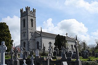
Donaghpatrick is a village and townland in County Meath, Ireland. It lies approximately 5 km northwest of Navan off the R147 regional road between Navan and Kells on the northern bank of the River Blackwater. The Irish language name of the townland, Domhnach Phádraig, means "the church of Patrick". The local Church of Ireland church, dedicated to Saint Patrick, was built in 1896 close to the site of a much earlier church, and incorporating parts of a medieval tower house.

Oldbridge is a townland near Drogheda in County Meath, Ireland. The area is home to the Boyne Navigation, the Battle of the Boyne Interpretive Centre and the southern half of the Mary McAleese Boyne Valley Bridge.
Carlanstown is a village and townland in County Meath, Ireland. As of the 2016 census, there were 664 people living in the village.

Ballinea or Ballina, is a village and townland in County Westmeath, Ireland. It is located to the west of Mullingar, on the R390 road. The Royal Canal flows through the village, with the Ballinea Bridge being used to cross to the western side.
Clonsilla or "Clonsillagh" is a civil parish and a townland located in the south-western corner of the modern county of Fingal, Ireland. The civil parish is part of the ancient barony of Castleknock. It is centred on the suburban village of Clonsilla. In geology, the parish rests on a substratum of limestone and comprises 2943 statute acres, the whole of which is arable land. It is roughly bounded to the north by the old "Navan Road" – the modern N3; to the east by the civil parish of Castleknock; to the south by the River Liffey; to the south-east by the civil parish of Leixlip, chiefly in County Kildare, and to the north-west by the civil parish of Dunboyne in County Meath.