Drumconrath

Last updated

Drumconrath
Droim Conrach
Village
Church of SS. Peter and Paul, Drumcondra - geograph.org.uk - 544266.jpg
Former Anglican church in Drumconrath
Ireland adm location map.svg
Red pog.svg
Drumconrath
Location in Ireland
Coordinates: 53°51′N6°39′W / 53.850°N 6.650°W / 53.850; -6.650
Country Ireland
Province Leinster
County County Meath
Area
  Total2.19 km2 (0.85 sq mi)
Population
 (2016) [1]
345

Drumconrath or Drumcondra [2] (historically Drumconra, from Irish : Droim Conrach, meaning 'ridge of Conrach') [3] is a small village in north County Meath, Ireland. The parish borders County Louth and is also close to the borders of Counties Monaghan and Cavan. As of the 2016 census, the village had a population of 345 people. [1]

Contents

The village lies in a parish, Drumconrath and Meath Hill parish, within the Roman Catholic Diocese of Meath. [4]

History

There is evidence of settlement in the area since before 200 BC in the ancient pathways and ringforts at Corstown and Drumsilagh. Tuath Conraige of the Mugdorna, an Airgíalla tribe mostly in Monaghan, occupied the area in the early Middle Ages and gave their name to the area.

During the Late Middle Ages, Drumconrath was literally "Beyond the Pale" being the first Gaelic Settlement you meet leaving the Pale from Ardee. It was a hostile place for the English who left the safety of the Pale and several battles took place in the village.[ citation needed ] The battle of Ballyhoe (1539 AD) between the O'Neills and the English, took place nearby.[ citation needed ] Of this battle, local folklore says that a treasure was thrown into the lake during the battle and when a true Irish Gael on a white horse comes, he will swoop into the lake and take it.[ citation needed ]

The remains of a monastery on Church Hill, destroyed because of Henry VIII's Dissolution of the Monastery Act, overlooks Lough Braken lake. Here there are views of the Mourne Mountains in one direction and the Dublin Mountains in the other.[ citation needed ]

During the 1798 rebellion, five parishioners were killed by the Louth Militia for refusing to allow them entry to the Church in the village. The area had strong Ribbonmen support and six men from the area were hanged for their part in the infamous burning of the Wildgoose Lodge Murders nearby. [5] A number of local men fought in the Anglo-Irish War and the Irish Civil War with nearby Kingscourt Brigade.[ citation needed ] It is recorded that this Brigade fired the last shot of the Anglo-Irish War at 11:20 on 11 June 1921, twenty minutes after the truce. [6]

A movie, released in October 2016, was filmed in and near Drumconrath. The movie, "The Wilde Goose Lodge", [7] involved a number of local people and actors.[ citation needed ]

Amenities

Set in forested drumlin countryside and surrounded by small lakes, the area around Drumconrath is a long-established angling centre with a number of walking areas.[ citation needed ] The River Dee, Lough Bracken, and the smaller lakes of Corstown and Balrath are situated in this area.

Muldoon's Bar front Muldoons bar and funeral directors Drumconrath.jpg
Muldoon's Bar front

Village amenities including a doctor's GP practice, post office, hair salon, pharmacy, butchers, primary school, grocery store and a B&B.[ citation needed ] There are three pubs in the village, The Old Thatch, Fay's Bar and Muldoon's.[ citation needed ] There is a community centre in the village and a pitch & putt course to the rear. St. Peter & Paul's National School is situated on the Kingscourt road at the end of the village. [8]

There are two churches in the village. Saint Peter's Church of Ireland (now closed) and Saint Peter & Paul's Catholic Church. There are some graves surrounding Saint Peter's Church, and the village has two other cemeteries on the Ardee Road (one Catholic and one Protestant).[ citation needed ]

The local GAA team, Drumconrath GAA, has facilities on the Navan road in Birdhill. The club also recruits players from the local parish of Meath-Hill to form the team "Drumconrath-Meath-Hill".[ citation needed ]

Related Research Articles

<span class="mw-page-title-main">County Louth</span> County in Ireland

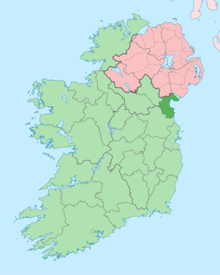
County Louth is a coastal county in the Eastern and Midland Region of Ireland, within the province of Leinster. Louth is bordered by the counties of Meath to the south, Monaghan to the west, Armagh to the north and Down to the north-east, across Carlingford Lough. It is the smallest county in Ireland by land area and the 17th most populous, with just over 139,100 residents as of 2022. The county is named after the village of Louth. Louth County Council is the local authority for the county.

<span class="mw-page-title-main">Ardee</span> Town in County Louth, Ireland

Ardee is a town and townland in County Louth, Ireland. It is located at the intersection of the N2, N52, and N33 roads. The town shows evidence of development from the thirteenth century onward but as a result of the continued development of the town since then much of the fabric of the medieval town has been removed.

<span class="mw-page-title-main">Drumshanbo</span> Town in County Leitrim, Ireland

Drumshanbo is a small town situated in the heart of County Leitrim, Ireland. Drumshanbo is surrounded by a scenic area of soft rolling hills, woodlands, lakes and the Sliabh an Iarainn and Arigna mountains. It is a well preserved town with traditional pubs, shops, and restaurants.

<span class="mw-page-title-main">Shercock</span> Small town in County Cavan, Ireland

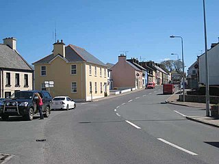
Shercock ; Irish: Searcóg) is a small town and civil parish in the east of County Cavan, Ireland. As of the 2016 census, the population of the town was 588.

<span class="mw-page-title-main">Nobber</span> Village in County Meath, Ireland

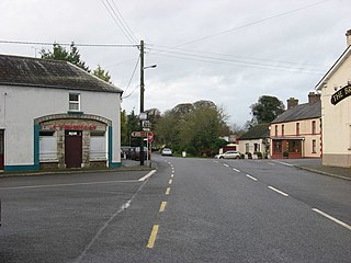
Nobber is a village in north County Meath, Ireland. It is on the Navan–Kingscourt road (R162), about 19 kilometres (12 mi) north of Navan. This places the village about 60 kilometres (37 mi) from the M50 motorway, the orbital motorway of Dublin. The town of Kells is to the west and the town of Ardee to the east and the town of Kingscourt is to the north. Villages that border the parish are Kilmainhamwood, Moynalty and Kilbeg to the west, Castletown-Kilpatrick to the south and Drumconrath and Lobinstown to the east.

<span class="mw-page-title-main">Drumkeeran</span> Village in County Leitrim, Ireland

Drumkeeran, also Drumkeerin, is a village and townland in County Leitrim, Ireland, located at the junction of the R280 and R200 roads. It is situated in drumlin hills at the foot of Corry Mountain, just north of Lough Allen.

<span class="mw-page-title-main">Regional road (Ireland)</span> Class of road in Ireland

A regional road in the Republic of Ireland is a class of road not forming a major route, but nevertheless forming a link in the national route network. There are over 11,600 kilometres of regional roads. Regional roads are numbered with three-digit route numbers, prefixed by "R". The equivalent road category in Northern Ireland are B roads.

<span class="mw-page-title-main">Ballybay</span> Town in County Monaghan, Ireland

Ballybay is a town and civil parish in County Monaghan, Ireland. The town is centred on the crossroads of the R183 and R162 regional roads.

<span class="mw-page-title-main">Tullyallen, County Louth</span> Village in Ireland

Tullyallen is a village, civil parish and townland 6 km north-west of the town of Drogheda in County Louth, Ireland. It is in the historic Barony of Ferrard. It is located in the historical Boyne Valley, in the Catholic parish of Mellifont ; it is also close to Newgrange, Knowth and Dowth burial mounds, Monasterboice monastery, and to the Battle of the Boyne site.

<span class="mw-page-title-main">Louth, County Louth</span> Village in County Louth, Ireland

Louth is a village at the heart of County Louth, Ireland. It is roughly 11 km south-west of the town of Dundalk, 10.9 km to neighbouring town Ardee. The village is approximately 15 km south-east of Carrickmacross town in County Monaghan. The village gave its name to the county.

<span class="mw-page-title-main">Kingscourt</span> Town in County Cavan, Ireland

Kingscourt, historically known as Dunaree, is a town in County Cavan, Ireland. It is located near the Cavan–Meath border. The town was founded near the site of the old village of Cabra, by Mervyn Pratt, towards the end of the 18th century, and was completed by his brother, The Rev. Joseph Pratt.

<span class="mw-page-title-main">Achaidh Leithdeircc</span> Ancient location in Ireland, reputed site of a battle or battles circa 331AD

Achaidh Leithdeircc is an ancient location in Ireland reputed to be the site of a historic battle, or series of battles, around the year 331AD, in which the forces of the Three Collas along with men of Connaught eventually conquered vast tracts of territory from the tribes of the Ulaid. The prehistoric royal site of Navan Fort was burnt and plundered and ultimately this territory would re-emerge as part of the kingdom or federation of Airgíalla.

Magheracloone is a parish in south County Monaghan. Its name comes from the Irish Machaire Cluana which means 'plain of meadow'. A generally hilly parish; its name is derived from its most important place in ancient times; a flat area of land in the townland of Camaghy, on which the sports ground and ancient church of St. Molua were located. The parish covers 12,952 statute acres in area, making it the largest parish in South Monaghan. The parish borders three neighbouring counties; Cavan, Louth and Meath..

<span class="mw-page-title-main">Mountnugent</span> Village in County Cavan, Ireland

Mountnugent, or Mount Nugent, historically known as Dalysbridge, is a village and townland in southern County Cavan, Ireland. The village is on the R154 regional road, at a river crossing near Lough Sheelin.

<span class="mw-page-title-main">River Dee (Ireland)</span> River in eastern Ireland

The River Dee is a river in eastern Ireland, flowing from County Cavan to flow into the River Glyde near the coast, in County Louth.

<span class="mw-page-title-main">Burning of Wildgoose Lodge</span>

The Burning of Wildgoose Lodge was an arson and murder attack on Wildgoose Lodge, County Louth, Ireland, on the night of 29–30 October 1816, in which eight occupants were killed, including an infant aged five months. The house was near the County Monaghan border, in the townland of Reaghstown, civil parish of Philipstown, barony of Ardee. Eighteen men were executed for the crime, many of them innocent. The event inspired an 1830 short story by William Carleton (1794–1869) and the circumstances have been the subject of historical and political debate.

<span class="mw-page-title-main">Stonetown, County Louth</span> Village in Leinster, Ireland

Stonetown is a small rural community spanning the townlands of Stonetown Upper and Stonetown Lower in County Louth. It lies in the parish of Louth, 10 kilometres from Dundalk, County Louth, and 11 kilometres from Carrickmacross, County Monaghan. The community consists of a small chapel, a primary school, a football field and a community centre.

<span class="mw-page-title-main">Kilmainhamwood</span> Village in County Meath, Ireland

Kilmainhamwood, historically simply Killmainham, is a village and townland in north County Meath, Ireland. The village is built on the River Dee and is situated north of Whitewood Lake. The village is located on local roads. Neighbouring parishes are Kingscourt to the north, Drumconrath to the east, Nobber to the south-east, Moynalty to the south and Bailieborough to the west.

<span class="mw-page-title-main">Drumcar</span> Village in County Louth, Ireland

Drumcar is a village and a historical parish, in the barony of Ardee, County Louth, Leinster, northeastern Ireland.

<span class="mw-page-title-main">Drum, County Monaghan</span> Village in County Monaghan, Ulster, Ireland

Drum is a village and townland in the west of County Monaghan in the Republic of Ireland. It is notable for being one of the only Protestant-majority settlements in the Republic of Ireland.

References

  1. 1 2 "Sapmap Area - Settlements - Drumconrath". Census 2016. Central Statistics Office. April 2016. Retrieved 14 February 2020.[ permanent dead link ]
  2. "Drumcondra switches counties!". independent. Retrieved 7 June 2022.
  3. "Droim Conrach / Drumcondra (see archival records)". logainm.ie. Placenames Database of Ireland. Retrieved 15 October 2021.
  4. "Drumconrath & Meath Hill Parish". drumconrathparish.ie. Archived from the original on 22 February 2010. The parish of Drumconrath and Meath Hill is situated in the north of the diocese of Meath
  5. "The Murders at Wildgoose Lodge". fourcourtspress.ie. Archived from the original on 19 February 2013. Retrieved 2012-01-05.
  6. The Royal Irish Constabulary and the Black and Tans in County Louth 1919-1922 / Stephen O'Donnell
  7. "Wild Goose Lodge (2016) - IMDb". 28 October 2016.
  8. "St. Peter and Paul's N.S, Drumconrath, Co. Meath". drumconrathns.com. Retrieved 15 October 2021.