
Doniphan County is the northeasternmost county in the U.S. state of Kansas. Its county seat is Troy, and its most populous city is Wathena. As of the 2020 census, the county population was 7,510. The county was named after Alexander Doniphan, a Mexican–American War hero. It is bounded on the east by the Missouri River, to the south by Atchison County and to the west by Brown County.

Brown County is a county located in the northeastern portion of the U.S. state of Kansas. Its county seat and most populous city is Hiawatha. As of the 2020 census, the county population was 9,508. The county was named after Albert G. Brown, a U.S. Senator from Mississippi and Kansas statehood advocate. The Kickapoo Indian Reservation of Kansas, the majority of the Sac and Fox Reservation, and the majority of the Iowa Reservation of Kansas and Nebraska are located within the county.

Atchison County is a county located in the northeastern portion of the U.S. state of Kansas. Its county seat and most populous city is Atchison. As of the 2020 census, the county population was 16,348. The county was named in honor of David Atchison, a U.S. Senator from Missouri and border ruffian during the "Bleeding Kansas" era.

Highland is a city in Doniphan County, Kansas, United States. As of the 2020 census, the population of the city was 903. It is home to Highland Community College.
Severance is a city in Doniphan County, Kansas, United States. As of the 2020 census, the population of the city was 76.
Wathena is a city in Doniphan County, Kansas, United States, located about 5 miles (8.0 km) west of St. Joseph, Missouri. As of the 2020 census, the population of the city was 1,246.

Doniphan is a city in Ripley County, Missouri, United States. The population was 1,781 at the 2020 census. It is the county seat of Ripley County.
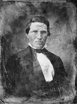
Alexander William Doniphan was a 19th-century American attorney, soldier and politician from Missouri who is best known today as the man who prevented the summary execution of Joseph Smith, founder of the Church of Jesus Christ of Latter Day Saints, at the close of the 1838 Mormon War in that state. He also achieved renown as a leader of American troops during the Mexican–American War, as the author of a legal code that still forms the basis of New Mexico's Bill of Rights, and as a successful defense attorney in the Missouri towns of Liberty, Richmond and Independence.
Bendena is a census-designated place (CDP) in Doniphan County, Kansas, United States. As of the 2020 census, the population was 117. The community is part of the St. Joseph, MO–KS Metropolitan Statistical Area.
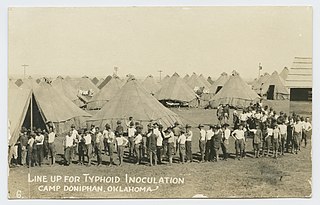
Camp Doniphan was a military base adjacent to Fort Sill, just outside Lawton, in Comanche County, Oklahoma, that was activated for use in World War I for artillery training. The post was closed in 1918 and incorporated into Fort Sill.

Iowa Point is an unincorporated community in northeastern Doniphan County, Kansas, United States.
Fanning is an unincorporated community in Doniphan County, Kansas, United States. Fanning is located along K-7, 5 miles (8.0 km) northwest of Troy.
Sparks is an unincorporated community in Doniphan County, Kansas, United States. Sparks is located along K-7, 4.2 miles (6.8 km) east of Highland.
Purcell is an unincorporated community in Doniphan County, Kansas, United States. It is located 5 miles (8.0 km) east of Everest, south of K-20, on highway K-137.
Moray is an unincorporated community in Doniphan County, Kansas, United States.
Brenner is an unincorporated community in Wayne Township, Doniphan County, Kansas, United States.
Palermo is an unincorporated community in Doniphan County, Kansas, United States.
Blair is an unincorporated community in Doniphan County, Kansas, United States.
Black Jack is an unincorporated community in Douglas County, Kansas, United States.
Geary is a ghost town in Wayne Township, Doniphan County, Kansas, United States.


