Severance, Kansas

Last updated

Severance, Kansas
Doniphan County Kansas Incorporated and Unincorporated areas Severance Highlighted.svg
Location within Doniphan County and Kansas
Map of Doniphan Co, Ks, USA.png
Coordinates: 39°46′00″N95°15′01″W / 39.76667°N 95.25028°W / 39.76667; -95.25028 [1]
Country United States
State Kansas
County Doniphan
Founded1869
Platted 1869
Incorporated 1877
Named for John Severance
Area
[2]
  Total0.14 sq mi (0.36 km2)
  Land0.14 sq mi (0.36 km2)
  Water0.00 sq mi (0.00 km2)
Elevation
[1]
948 ft (289 m)
Population
 (2020) [3]
  Total76
  Density540/sq mi (210/km2)
Time zone UTC-6 (CST)
  Summer (DST) UTC-5 (CDT)
ZIP code
66087
Area code 785
FIPS code 20-64025
GNIS ID 2396577 [1]
Website City website

Severance is a city in Doniphan County, Kansas, United States. [1] As of the 2020 census, the population of the city was 76. [3]

Contents

History

Severance was laid out in 1869. [4] It was named for John Severance, one of its founders. [5] A railroad depot was built in Severance in 1874. [6] Severance was incorporated as a city in 1877. [7]

A post office was opened in Severance in 1869, and remained in operation until it was discontinued in 1992. [8]

Geography

Severance is located along the Wolf River. [9] According to the United States Census Bureau, the city has a total area of 0.14 square miles (0.36 km2), all land. [10]

Demographics

Historical population
CensusPop.Note
1880 375
1890 3770.5%
1900 42412.5%
1910 383−9.7%
1920 350−8.6%
1930 312−10.9%
1940 266−14.7%
1950 197−25.9%
1960 146−25.9%
1970 128−12.3%
1980 1344.7%
1990 98−26.9%
2000 10810.2%
2010 94−13.0%
2020 76−19.1%
U.S. Decennial Census

2010 census

As of the census [11] of 2010, there were 94 people, 39 households, and 21 families residing in the city. The population density was 671.4 inhabitants per square mile (259.2/km2). There were 49 housing units at an average density of 350.0 per square mile (135.1/km2). The racial makeup of the city was 100.0% White.

There were 39 households, of which 25.6% had children under the age of 18 living with them, 41.0% were married couples living together, 10.3% had a female householder with no husband present, 2.6% had a male householder with no wife present, and 46.2% were non-families. 38.5% of all households were made up of individuals, and 20.6% had someone living alone who was 65 years of age or older. The average household size was 2.41 and the average family size was 3.29.

The median age in the city was 43.5 years. 25.5% of residents were under the age of 18; 9.6% were between the ages of 18 and 24; 17.1% were from 25 to 44; 29.7% were from 45 to 64; and 18.1% were 65 years of age or older. The gender makeup of the city was 47.9% male and 52.1% female.

2000 census

As of the census [12] of 2000, there were 108 people, 46 households, and 28 families residing in the city. The population density was 841.8 inhabitants per square mile (325.0/km2). There were 53 housing units at an average density of 413.1 per square mile (159.5/km2). The racial makeup of the city was 100.00% White.

There were 46 households, out of which 34.8% had children under the age of 18 living with them, 43.5% were married couples living together, 15.2% had a female householder with no husband present, and 37.0% were non-families. 32.6% of all households were made up of individuals, and 15.2% had someone living alone who was 65 years of age or older. The average household size was 2.35 and the average family size was 3.00.

In the city, the population was spread out, with 28.7% under the age of 18, 8.3% from 18 to 24, 25.9% from 25 to 44, 24.1% from 45 to 64, and 13.0% who were 65 years of age or older. The median age was 34 years. For every 100 females, there were 96.4 males. For every 100 females age 18 and over, there were 102.6 males.

The median income for a household in the city was $25,313, and the median income for a family was $27,083. Males had a median income of $25,625 versus $15,500 for females. The per capita income for the city was $13,690. There were 21.4% of families and 26.6% of the population living below the poverty line, including 41.9% of under eighteens and 29.4% of those over 64.

Education

The community is served by Doniphan West USD 111 public school district.

Notable people

Harry Chapman, catcher in Major League Baseball

Related Research Articles

<span class="mw-page-title-main">Hamlin, Kansas</span> City in Brown County, Kansas

Hamlin is a city in Brown County, Kansas, United States. As of the 2020 census, the population of the city was 25.

<span class="mw-page-title-main">Morganville, Kansas</span> City in Clay County, Kansas

Morganville is a city in Clay County, Kansas, United States. As of the 2020 census, the population of the city was 180.

<span class="mw-page-title-main">Waverly, Kansas</span> City in Coffey County, Kansas

Waverly is a city in Coffey County, Kansas, United States. As of the 2020 census, the population of the city was 574.

<span class="mw-page-title-main">Hepler, Kansas</span> City in Crawford County, Kansas

Hepler is a city in Crawford County, Kansas, United States. As of the 2020 census, the population of the city was 90.

<span class="mw-page-title-main">Norcatur, Kansas</span> City in Decatur County, Kansas

Norcatur is a city in Decatur County, Kansas, United States. As of the 2020 census, the population of the city was 159.

<span class="mw-page-title-main">Denton, Kansas</span> City in Doniphan County, Kansas

Denton is a city in Doniphan County, Kansas, United States. As of the 2020 census, the population of the city was 130.

<span class="mw-page-title-main">Elwood, Kansas</span> City in Doniphan County, Kansas

Elwood is a city in Doniphan County, Kansas, United States, located west across the Missouri River from Saint Joseph, Missouri. As of the 2020 census, the population of the city was 1,125.

<span class="mw-page-title-main">Highland, Kansas</span> City in Doniphan County, Kansas

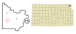
Highland is a city in Doniphan County, Kansas, United States. As of the 2020 census, the population of the city was 903. It is home to Highland Community College.

<span class="mw-page-title-main">Leona, Kansas</span> City in Doniphan County, Kansas

Leona is a city in Doniphan County, Kansas, United States. As of the 2020 census, the population of the city was 41.

<span class="mw-page-title-main">Troy, Kansas</span> City in Doniphan County, Kansas

Troy is a city in and the county seat of Doniphan County, Kansas, United States. As of the 2020 census, the population of the city was 964.

<span class="mw-page-title-main">Wathena, Kansas</span> City in Doniphan County, Kansas

Wathena is a city in Doniphan County, Kansas, United States, located about 5 miles (8.0 km) west of St. Joseph, Missouri. As of the 2020 census, the population of the city was 1,246.

<span class="mw-page-title-main">White Cloud, Kansas</span> City in Doniphan County, Kansas

White Cloud is a city in Doniphan County, Kansas, United States. As of the 2020 census, the population of the city was 115. It was named for Francis White Cloud, a son of Chief White Cloud of the Iowa people. White Cloud is the seat of government for the Iowa Tribe of Kansas and Nebraska.

<span class="mw-page-title-main">Netawaka, Kansas</span> City in Jackson County, Kansas

Netawaka is a city in Jackson County, Kansas, United States. As of the 2020 census, the population of the city was 139.

<span class="mw-page-title-main">Mission, Kansas</span> City in Kansas, United States

Mission is a city in Johnson County, Kansas, United States, and part of the Kansas City Metropolitan Area. As of the 2020 census, the population of the city was 9,954.

<span class="mw-page-title-main">Westwood Hills, Kansas</span> City in Kansas, United States

Westwood Hills is a city in Johnson County, Kansas, United States. As of the 2020 census, the population of the city was 400. It is the most densely populated city in the Kansas City Metropolitan Area at 6,240 people per square mile. It borders Kansas City, Missouri.

<span class="mw-page-title-main">Lenora, Kansas</span> City in Norton County, Kansas

Lenora is a city in Norton County, Kansas, United States. As of the 2020 census, the population of the city was 207.

<span class="mw-page-title-main">Langdon, Kansas</span> City in Reno County, Kansas

Langdon is a city in Reno County, Kansas, United States. As of the 2020 census, the population of the city was 39.

<span class="mw-page-title-main">Liberty, Missouri</span> City in Missouri, United States

Liberty is a city in and the county seat of Clay County, Missouri, United States and is a suburb of Kansas City, located in the Kansas City Metropolitan Area. As of the 2020 United States Census the population was 30,167. Liberty is home to William Jewell College.

<span class="mw-page-title-main">Doniphan, Nebraska</span> Village in Hall County, Nebraska, United States

Doniphan is a village in Hall County, Nebraska, United States. The population was 809 at the 2020 census. It is part of the Grand Island, Nebraska Micropolitan Statistical Area.

<span class="mw-page-title-main">Bendena, Kansas</span> Unincorporated community in Doniphan County, Kansas

Bendena is an unincorporated community in Doniphan County, Kansas, United States. As of the 2020 census, the population of the community and nearby areas was 117.

References

  1. 1 2 3 4 U.S. Geological Survey Geographic Names Information System: Severance, Kansas
  2. "2019 U.S. Gazetteer Files". United States Census Bureau. Retrieved July 24, 2020.
  3. 1 2 "Profile of Severance, Kansas in 2020". United States Census Bureau. Archived from the original on June 26, 2022. Retrieved June 26, 2022.
  4. Gray, Patrick Leopoldo (1905). Gray's Doniphan County History: A Record of the Happenings of Half a Hundred Years. Roycroft Press. pp.  45.
  5. Kansas State Historical Society (1916). Biennial Report of the Board of Directors of the Kansas State Historical Society. Kansas State Printing Plant. pp.  178.
  6. Blackmar, Frank Wilson (1912). Kansas: A Cyclopedia of State History, Volume 2. Standard Publishing Company. pp.  671.
  7. History of the State of Kansas: Containing a Full Account of Its Growth from an Uninhabited Territory to a Wealthy and Important State. A. T. Andreas. 1883. p.  490.
  8. "Kansas Post Offices, 1828-1961 (archived)". Kansas Historical Society. Archived from the original on October 9, 2013. Retrieved June 8, 2014.
  9. DeLorme (2003), Kansas Atlas & Gazetteer, p. 26, Yarmouth, Maine: DeLorme, ISBN   0-89933-342-7.
  10. "US Gazetteer files 2010". United States Census Bureau. Archived from the original on January 25, 2012. Retrieved July 6, 2012.
  11. "U.S. Census website". United States Census Bureau . Retrieved July 6, 2012.
  12. "U.S. Census website". United States Census Bureau . Retrieved January 31, 2008.

Further reading