Donji Humac

Last updated • 7 min readFrom Wikipedia, The Free Encyclopedia
Donji Humac
Donji Humac - Crkva Fabijan i Sebastijan - Brac.jpg
Church of Saint Fabian and Sebastian in Donji Humac
Croatia location map.svg
Red pog.svg
Donji Humac
Location of Donji Humac in Croatia
Coordinates: 43°20′N16°34′E / 43.333°N 16.567°E / 43.333; 16.567
CountryFlag of Croatia.svg  Croatia
County Flag of Split-Dalmatia County.svg Split-Dalmatia
Island Brač
Municipality Nerežišća
Area
[1]
  Total7.6 km2 (2.9 sq mi)
Elevation
313 m (1,027 ft)
Population
 (2021) [2]
  Total173
  Density23/km2 (59/sq mi)
Time zone UTC+1 (CET)
  Summer (DST) UTC+2 (CEST)
Postal code
21 423
Area code 021
Licence plate ST

Donji Humac is one of the oldest settlements on the Croatian island of Brač, located on an inland hill. The top of the hill is marked by a widely visible Baroque bell-tower. The nearby Kopačina cave was inhabited more than 13,200 years ago. As of the 2011 census, Donji Humac has a population of 177 [3] – far below its height at the beginning of the 20th century of more than 500 people, before several waves of emigration depopulated the settlement.

Contents

The village is about 1 kilometre (0.62 mi) north-west of Nerežišća, and linked to Supetar, the largest city of Brač, through a paved 6 kilometres (3.7 mi) road northwards, mostly following state road D113. A county road (Ž6188) leads westwards to Dračevica, about 2.4 kilometres (1.5 mi) away.

To the south and west of the settlement are fertile fields, where traces of pre-Croatian habitation have been found. Some of these traces, such as Roman ornaments, have been incorporated into the houses of the settlement, such as those of the Dragičević and Laurić families. [4]

Donji Humac is surrounded by a number of quarries. The local stone gave the settlement its distinct look very early on, and many old elements of the settlement are still preserved. The closeness to the quarries also led to a tradition of artistic stonemasonry in the village, which continues today. In 1996, an international meeting of stonemasons led to the creation of a number of monuments which are now spread throughout the settlement. Besides stone, the main sources of income have traditionally been wine, olives, cherries, sheep husbandry, hunting and, more recently, tourism.

History

It is assumed that in the 11th century, Donji Humac was called Gomilje or Gomirje and had already been a settlement for a while. In 1080, a Brač person named Tišen bought from a Split aristocrat named Cassarias some houses and land in Gomilje. Gomilje lies on the western side of the Humac hill, just below Kis (from the Latin word ecclesia ). A cloister and the oldest buildings of Donji Humac are expected to have been in Kis, close to the Smokvica pond. [4]

Old stone houses of Donji Humac Donji Humac house old.jpg
Old stone houses of Donji Humac

The name Humac is mentioned in sources for the first time in 1305. The settlers are supposed to have come from the area of Saint Elias and Banje to the west of Humac. The name Donji Humac (literally translated as "lower hillside") was only introduced later to differentiate it from Gornji Humac ("upper hillside"), which is on the eastern side of Brač. Traditionally in Slavic culture, the east was associated with up and the west with down.

In medieval times, most of the population of Brač lived inland, as the coast was too dangerous due to pirate and other attacks. During that time, the northwest of the island belonged to Donji Humac, including the settlements Sutivan and Mirca, both of which are larger than Donji Humac today. In the 20th century, the worsening economic situation in Donji Humac – first through the grape phylloxera louse, which destroyed several grape harvests and thus the wine production; later World War II and its aftermath – led to several waves of emigration. This has left Donji Humac today with only a third or quarter of the population of a century ago.

Kopačina cave

Entrance to the Kopacina cave Kopacina - jeskyne s nalezy pozustatku neandrtalce a jeskynn.jpg
Entrance to the Kopačina cave

Cultural objects dug out from the cave of Kopačina, 1 kilometre (0.62 mi) to the north-west of Donji Humac, indicate human habitation since the Stone Age. The cave is about 12 metres (13 yd) long and has two chambers.

Remains of wild horses, birds, deers, and bears were found, as well as stone knives, drills, arrow tips, and other Mesolithic tools, and numerous Mesolithic flint weapons, have been found in the front chamber. In the middle part of the cave, ceramics and an early Bronze Age axe have been found. [5] In the back of the cave, human remains from the Epipaleolithic and the Mesolithic have been found. The radiolarite rock used for some of the objects found in the cave is not known to exist on the Dalmatian islands or coast, and indicates connections to the Dalmatian hinterland, likely the mouth of the Neretva or the Budva region. [6]

The cave was first explored by Frane Bulić in 1890. It was previously thought that the cave was continuously inhabited from the late Upper Paleolithic through the Mesolithic until the Bronze Age, i.e. from the 8th to the 3rd millennium BC. More recent research indicates an even older original usage – before 13,200 BP (although it is unknown how long before) – but not continuously to the Bronze Age. [6] That would make the findings in the cave possibly the oldest traces of human settlement not only on Brač but in all of Dalmatia.

Churches

Procession to honor St Ana St Ana procession.jpg
Procession to honor St Ana

The parish church of Saint Fabian and Sebastian is on the top of Donji Humac and dominates the view on the hill with its widely visible Baroque bell tower. Originally, there was a church here that old documents called Stomorica (Santa Maria). Linguistically, the name indicates that the church was built in the 10th century. The altar has an inscription dated to 1175. In the 14th century, the church was expanded to double its previous size with Romanesque arches. From 1725 to 1742, the church was again expanded. The Baroque bell tower and the two side ships of the church were added at that time, built by Ignac Macanović from Trogir. The church organ was built in 1775 by Franco Dazzi.

The church hosts a fresco of Christ sitting on his throne between his mother and St John the Baptist, dating from the 13th century. According to legend, every year on January 20, the day of St Fabian and Sebastian, dew would fall on the fresco, which led to many pilgrims coming to Donji Humac. In the church, more than 250 votive offerings gathered over the centuries are on display. Later, the main pilgrimage to Donji Humac moved to July 26, the day of Saint Ana. Today the annual feast of Saint Ana includes a large celebration and the blessing of motor vehicles.

The old cemetery of Donji Humac is around the parish church. A new cemetery was opened in the 17th century on the western slope of the hill, with a small church dedicated to Our Lady of Carmel.

The pre-Romanesque church of Saint Elias is located about 800 metres (870 yd) to the west of Donji Humac, and dates to the 10th century. On its side are the remains of a Roman mausoleum. Some of the ornaments of the mausoleum were used when building Saint Elias. The mausoleum has been called the most beautiful ancient monument on the island. Saint Elias has an apse that is rectangular from the outside and a semi-circle from the inside. To the west of the church is the hill Trišćenik (Croatian trisk = thunder); this may be intended as a juxtaposition of the pagan thunder god with Saint Elias, who is known as the saint of thunder.

To the north of Donji Humac is the ruin of the church of Saint Luke , an early Romanesque church from the 11th or 12th century. The inside of the church hosts the earliest known sketch of a boat in Croatian medieval art. Surrounding Saint Lucas are a number of stone sarcophagi that document the tradition of creating these since Roman times.

Saint Andrew , north east of the town, was built in the 13th or 14th century, on top of Roman ancient ruins. Its roof has since collapsed. Around Saint Andrew, a number of old Croatian earrings and 11th century Byzantine coins have been found. A number of old chronicles of Brač mention a Benedictine cloister in the area, but the cloister has not been found.

Demographic development

As with most settlements on Brač, Donji Humac saw continuous growth since its settlement, gaining speed in the 19th century and reaching a height in the early 20th century – when particularly due to the grape phylloxera louse, the local production of wine broke down. This destroyed many of the available local economic opportunities, and to a large wave of emigration. People from Donji Humac have moved to Antofagasta in Chile, Perth in Australia, Auckland in New Zealand, the United States and later also Germany. [7]

Population census of the town
Year 1579 1645 1681 1705 1724 1738 1764 1857 1869 1880 1890 1900 1910 1931 1948 1961 1971 1981 1991 2001 2011 2021
Pop.90140130140196235238233333384455506540452442372256196210166157177
±%    +55.6%−7.1%+7.7%+40.0%+19.9%+1.3%−2.1%+42.9%+15.3%+18.5%+11.2%+6.7%−16.3%−2.2%−15.8%−31.2%−23.4%+7.1%−21.0%−5.4%+12.7%
Source: 1857-2021 Državni zavod za statistiku

Related Research Articles

<span class="mw-page-title-main">West Wycombe</span> Human settlement in England

West Wycombe is a small village and civil parish in Buckinghamshire, England, famed for its manor houses and its hills. It is 3 miles (4.8 km) west of High Wycombe.

<span class="mw-page-title-main">Brač</span> Island in Croatia

Brač is a Croatian island in the Adriatic Sea, with an area of 396 square kilometres (153 sq mi), making it the largest island in Dalmatia, and the third largest in the Adriatic. It is separated from the mainland by the Brač Channel, which is 5 to 13 km wide. The island's tallest peak, Vidova gora, or Mount St. Vid, stands at 780 m (2,560 ft), making it the highest point of the Adriatic islands. The island has a population of 13,931, living in twenty-two settlements, ranging from the main town Supetar, with more than 3,400 inhabitants, to Murvica, where less than two dozen people live. Brač Airport on Brač is the largest airport of all islands surrounding Split.

<span class="mw-page-title-main">Moulis-en-Médoc</span> Commune in Nouvelle-Aquitaine, France

Moulis-en-Médoc is a commune in the Gironde department in Nouvelle-Aquitaine in southwestern France.

<span class="mw-page-title-main">Diocletian's Palace</span> Historic site in Split, Croatia

Diocletian's Palace was built at the end of the third century AD as a residence for the Roman emperor Diocletian, and today forms about half of the old town of Split, Croatia. While it is referred to as a "palace" because of its intended use as the retirement residence of Diocletian, the term can be misleading as the structure is massive and more resembles a large fortress: about half of it was for Diocletian's personal use, and the rest housed the military garrison.

<span class="mw-page-title-main">Santa María la Real of Nájera</span> Monastery in Spain

Santa María la Real is a monastery in the small town of Nájera in the La Rioja community, Spain. Originally a royal foundation, it was ceded by Alfonso VI to the Cluniac order. It was an important pilgrimage stop on the Camino de Santiago. It is particularly well known for the woodwork in the choir of the church.

<span class="mw-page-title-main">Omiš</span> Town in Split-Dalmatia, Croatia

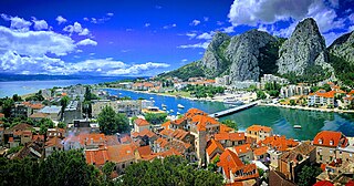
Omiš is a town and port in the Dalmatia region of Croatia, and a municipality in the Split-Dalmatia County. The town is approximately 25 kilometres south-east of Croatia's second largest city, Split, where the Cetina River meets the Adriatic Sea. Omiš municipality has a population of 14,936 and its area is 266 square kilometres (103 sq mi).

<span class="mw-page-title-main">Blato, Korčula</span> Municipality in Dubrovnik–Neretva, Croatia

Blato is a municipality on the island of Korčula in Croatia. It can be reached by the main island road from town of Korčula. The road runs through the forests in the middle of the island of Korčula.

<span class="mw-page-title-main">Vela Luka</span> Municipality in Dubrovnik-Neretva County, Croatia

Vela Luka is a small town and a municipality in Dubrovnik-Neretva County in southern Dalmatia, Croatia. The town is located on the western side of the island of Korčula at the bottom of a wide bay which has many indented coves. Vela Luka developed at the beginning of the 19th century in a deep sheltered bay. Its name means "big harbour" in Croatian chakavian. Inhabitants of the Island of Korčula and Pelješac often refer to it simply as "Luka". It has several hotels and a medical centre called Kalos. The inhabitants are farmers, fishermen and workers in tourism. The town also has small industrial plants.

<span class="mw-page-title-main">Supetar</span> Town in Split-Dalmatia, Croatia

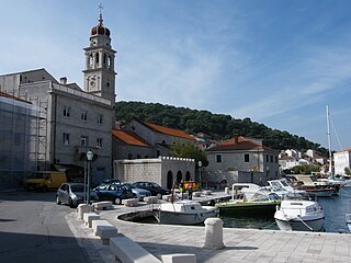
Supetar is a town on the northern part of the Dalmatian island of Brač, in the Split-Dalmatia County, in Croatia. It became the island's official centre in 1827. The town of Supetar includes Supetar itself and the three villages of Splitska, Škrip and Mirca.

<span class="mw-page-title-main">Biševo</span> Adriatic Sea island of Croatia

Biševo is a Croatian island in the Adriatic Sea. It is situated in the middle of the Dalmatian archipelago, five kilometers southwest of the Island of Vis. Its area is 5.8 km2 (2.2 sq mi) and it has a population of 15.

<span class="mw-page-title-main">Nerežišća</span> Municipality in Split-Dalmatia County, Croatia

Nerežišća is a village and a municipality on the island Brač in Croatia.

<span class="mw-page-title-main">Pučišća</span> Municipality on Brač, Croatia

Pučišća is a coastal town and a municipality on the island of Brač in Croatia. It is often listed as one of the prettiest villages in Europe. It is known for its white limestone and beautiful bay. The town has a population of 1,351.

<span class="mw-page-title-main">Selca, Brač</span> Municipality in Split-Dalmatia county, Croatia

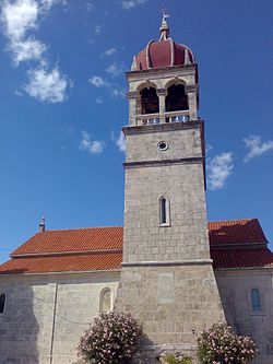
Selca is a municipality on the island of Brač in Croatia in the Split-Dalmatia County. It has a population of 1,804, 97.17% of which are Croats. Towns included in the municipality are: Selca, Sumartin, Povlja, Novo Selo which are home to numerous historical sites of various importance such as the Parish Church in Selca, which later came to be known as the "Cathedral of Brač", the 18th century church in Povlja, where the Charter of Povlja was found as well as the 10th century Church of Nikola located in Sumartin.

<span class="mw-page-title-main">History of Zagreb</span>

The history of Zagreb, the capital and largest city of Croatia, dates back to the Middle Ages. The Romans had built a settlement, Andautonia, in present-day Ščitarjevo. The name "Zagreb" was first used in 1094 at the founding of the Zagreb diocese in Kaptol, after the Slavs had arrived in the area. Zagreb became a free royal city in 1242. It was made the capital of Croatia in 1845 and elected its first mayor, Janko Kamauf, in 1851. According to the 2011 Croatian census, Zagreb had 792,875 inhabitants and was also Croatia's largest city by area.

<span class="mw-page-title-main">Aboud</span> Palestinian village in Ramallah and al-Bireh, State of Palestine

Aboud is a Palestinian village in the Ramallah and al-Bireh Governorate of the State of Palestine, in the central West Bank, northwest of Ramallah and 30 kilometers north of Jerusalem. Nearby towns include al-Lubban to the northeast and Bani Zeid to the northwest.

<span class="mw-page-title-main">Le Puy Cathedral</span> Cathedral in Haute-Loire, in France

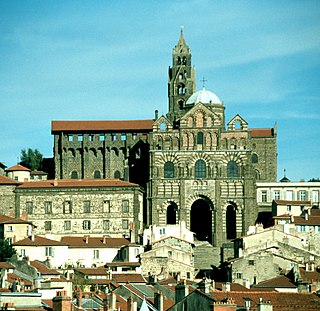
Le Puy Cathedral is a Roman Catholic church located in Le Puy-en-Velay, Auvergne, France. The cathedral is a national monument. It has been a centre of pilgrimage in its own right since before the time of Charlemagne, as well as being a stopover on the pilgrimage route to Santiago de Compostela. Since 1998 it has been part of a multi-location UNESCO World Heritage Site along France's Santiago pilgrimage routes. It is the seat of the Bishop of Le Puy.

<span class="mw-page-title-main">Saint-Avit-Sénieur</span> Commune in Nouvelle-Aquitaine, France

Saint-Avit-Sénieur is a commune in the Dordogne department in Nouvelle-Aquitaine in southwestern France.

<span class="mw-page-title-main">Cathedral of Saint Domnius</span> Church in Split, Croatia

The Cathedral of Saint Domnius, known locally as the Sveti Dujam or colloquially Sveti Duje, is the Catholic cathedral in Split, Croatia. The cathedral is the seat of the Archdiocese of Split-Makarska, currently headed by Archbishop Zdenko Križić. The Cathedral of St. Domnius is a complex of a church, formed from an Imperial Roman mausoleum, with a bell tower; strictly the church is dedicated to the Virgin Mary, and the bell tower to Saint Domnius. Together they form the Cathedral of St. Domnius.

<span class="mw-page-title-main">Humac, Hvar</span> Village in Croatia

Humac is an uninhabited hamlet on the island of Hvar, Croatia. It is connected by the D116 highway. Located 350 m (1,150 ft) above sea level, 10 km (6.2 mi) from Jelsa.

<span class="mw-page-title-main">Romanesque secular and domestic architecture</span> Period of architectural design

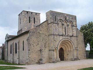
Romanesque architecture is an architectural style of medieval Europe characterised by semi-circular arches. The term "Romanesque" is usually used for the period from the 10th to the 12th century with "Pre-Romanesque" and "First Romanesque" being applied to earlier buildings with Romanesque characteristics. Romanesque architecture can be found across the continent, diversified by regional materials and characteristics, but with an overall consistency that makes it the first pan-European architectural style since Imperial Roman Architecture. The Romanesque style in England is traditionally referred to as Norman architecture.

References

  1. Register of spatial units of the State Geodetic Administration of the Republic of Croatia. Wikidata   Q119585703.
  2. "Population by Age and Sex, by Settlements" (xlsx). Census of Population, Households and Dwellings in 2021. Zagreb: Croatian Bureau of Statistics. 2022.
  3. Census of population, households and dwellings in 2021 (in Croatian and English), Croatian Bureau of Statistics, 2022, Wikidata   Q110945262
  4. 1 2 Andrija, Carli; Šimunović, Petar (1997). Brač : vodič po otoku. Golden marketing. ISBN   9536168324. OCLC   440140445.
  5. Čečuk, Božidar (1996). "Špilja Kopačina kod Donjeg Humca na otoku Braču". Arheološki Radovi I Rasprave. 12: 13–30.
  6. 1 2 Vukosavljević, Nikola; Perhoč, Zlatko; Čečuk, Božidar; Karavanić, Ivor (January 19, 2011). "Late Glacial knapped stone industry of Kopačina Cave". Vijesnik Za Arheologiju I Povijest Dalmatinsku.
  7. Derado, Klement; Čizmić, Ivan (1982). Iseljenici otoka Brača. Zagreb: SIZ za kulturu općine Brač.