
Nottinghamshire is a county in the East Midlands region of England, bordering South Yorkshire to the north-west, Lincolnshire to the east, Leicestershire to the south, and Derbyshire to the west. The traditional county town is Nottingham, though the county council is based at County Hall in West Bridgford in the borough of Rushcliffe, at a site facing Nottingham over the River Trent.

Heathrow or Heath Row was a wayside hamlet along a minor country lane called Heathrow Road in the ancient parish of Harmondsworth, Middlesex, England, on the outskirts of what is now Greater London. Its buildings and all associated holdings were demolished, along with almost all of the often grouped locality of The Magpies in 1944 for the construction of Heathrow Airport.

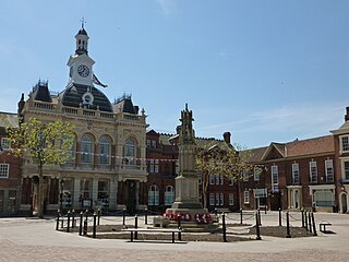
Newark-on-Trent or Newark is a market town and civil parish in the Newark and Sherwood district of the county of Nottinghamshire, England. It stands on the River Trent, the A1 – on the route of the ancient Great North Road, and the East Coast Main Line railway. The origins of the town are possibly Roman, as it lies on an important Roman road, the Fosse Way. The town grew around Newark Castle, now ruined, and a large market place, now lined with historic buildings. It was a centre for the wool and cloth trades. In the English Civil War, it was besieged by Parliamentary forces and relieved by Royalist forces under Prince Rupert. Today Newark has become a commuter town for the cities of Lincoln and Nottingham.
Retford, also known as East Retford, is a market town in Nottinghamshire, England, 31 miles (50 km) from Nottingham, and 23 miles (37 km) west of Lincoln. The population at the 2011 census was 22,013. The town is in the valley of the River Idle and the Chesterfield Canal passes through the centre. The village of Ordsall, west of the River Idle and the former hamlet of Thrumpton are suburbs. Retford is administered by Bassetlaw District Council, which itself is now a non-constituent partner member of the Sheffield City Region Combined Authority. Retford is twinned with Pfungstadt, Germany.

Gedling is a local government district with borough status in Nottinghamshire, England, whose council is based in Arnold, north-east of Nottingham. The population at the time of the 2011 census was 113,543.

Calverton is a village and civil parish, of some 3,300 acres (1,300 ha), in the Gedling district, about seven miles north-east of Nottingham, Nottinghamshire, England, and situated, like nearby Woodborough and Lambley, on one of the small tributaries of the Dover Beck. The 2011 census found 7,076 inhabitants in 2,987 households. About two miles to the north of the village is the site of the supposed deserted settlement of Salterford.

Arnold is a market town and unparished area in the ceremonial county of Nottinghamshire in the East Midlands of England. It is situated to the north-east of Nottingham's city boundary. Arnold's town centre is the largest in the Borough of Gedling and the most important in the northeastern part of the Greater Nottingham conurbation. Gedling Borough Council is headquartered in Arnold. Since 1968 Arnold has had a market, and the town used to have numerous factories associated with the hosiery industry. Nottinghamshire Police have been headquartered in Arnold since 1979. At the time of the 2011 census, Arnold had a population of 37,768.

The Leicester and Swannington Railway (L&S) was one of England's first railways, being opened on 17 July 1832 to bring coal from collieries in west Leicestershire to Leicester.
Crich is a village in the English county of Derbyshire. The population at the 2001 Census was 2,821 increasing to 2,898 at the 2011 Census. It has the National Tramway Museum inside the Crich Tramway Village, and at the summit of Crich Hill above, a memorial tower for those of the Sherwood Foresters regiment who died in battle, particularly in World War I.

Sherwood is a large district and ward of the city of Nottingham, in the English ceremonial county of Nottinghamshire. It is situated approximately 1.5 miles (2.4 km) north of Nottingham city centre. The population of the ward taken at the 2011 census was 15,414. It is bordered by Woodthorpe to the northeast, Mapperley to the east, Carrington to the south, New Basford and Basford to the west, and Daybrook and Bestwood to the north.

Clifton, Greater Manchester, England, lies alongside the Irwell Valley in the north of the City of Salford. Historically in Lancashire, it was a centre for coal mining, and once formed part of the Municipal Borough of Swinton and Pendlebury.

Besthorpe is a small village in north-east Nottinghamshire close to the border with Lincolnshire. It is a Civil Parish in the Newark & Sherwood district of Nottinghamshire. The population of the civil parish as of the 2011 census is 195. The village is on the A1133 between Newark and Gainsborough, and is 1.5 miles north of the larger village of Collingham, north east of Newark on Trent. The village lies 1 mile east of the River Trent and the River Fleet flows south to east parallel with the village & A1133. Besthorpe acquired Conservation Village status in 2006 because it has maintained much of its original layout focused on Low Road and the Green.

Clipstone in north Nottinghamshire is a small ex-coal mining village built on the site of an old army base and likely the site of a medieval royal palace. The population of the civil parish was 3,469 at the 2001 census, increasing to 4,665 at the 2011 census.

Mapperley is a residential and commercial area of north-eastern Nottingham, England. The area is bounded by Sherwood to the north-west, Thorneywood to the south and Gedling to the east.

This article is about the history of Nottingham.

Beddingham is an English village and civil parish in the Lewes district of East Sussex, at the junction between the London–Newhaven (A26) and south coast (A27) roads south-east of Lewes. The parish council joined with that of Glynde shortly after the Second World War, as Glynde and Beddingham, but they remain separate civil parishes.

Mark Steven Spencer is a British Conservative Party politician serving as the Member of Parliament (MP) for Sherwood since 2010. He was appointed Government Chief Whip of the House of Commons and Parliamentary Secretary to the Treasury by Prime Minister Boris Johnson in 2019.

Newton Leys is a district that covers the southern tip of Bletchley and straddles the boundary between the Borough of Milton Keynes and the rest of Buckinghamshire. The larger fraction of Newton Leys lies within Milton Keynes and forms a part of Bletchley and Fenny Stratford civil parish. It is separated from central Bletchley, Water Eaton and the Lakes Estate by the West Coast Main Line. The remaining fraction of Newton Leys lies within the (former) Aylesbury Vale district and forms a part of the Stoke Hammond civil parish, although the village of Stoke Hammond is situated on the other side of the A4146

The Lithgow Valley Colliery and Pottery Site is a heritage-listed former pottery and colliery and now pottery and visitor attraction at Bent Street, Lithgow, City of Lithgow, New South Wales, Australia. It was built from 1876 to 1945. It is also known as Lithgow Pottery and Brickworks. The property is privately owned. It was added to the New South Wales State Heritage Register on 2 April 1999.

